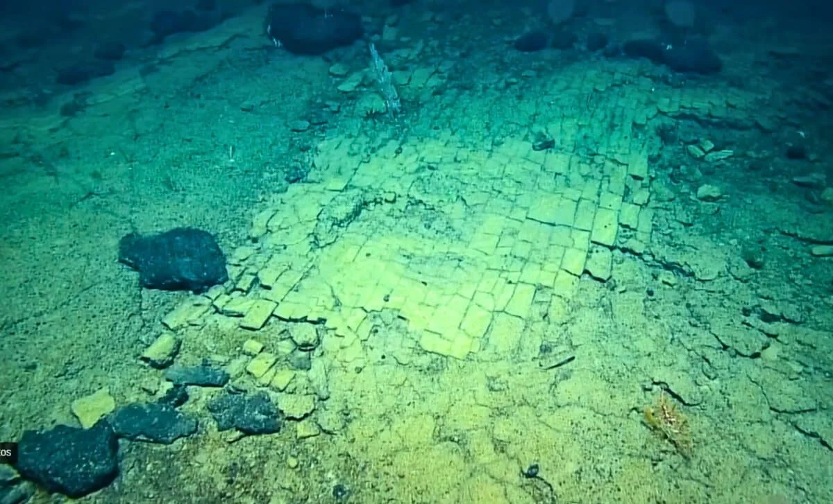
Scientists used autonomous underwater vehicles to map the underside of Antarctica's Dotson Ice Shelf, revealing complex terrain and uneven melting patterns driven by warm ocean currents. During a follow-up mission in 2024, the vehicle disappeared, raising concerns about the stability of ice shelves and their role in sea level rise, as melting accelerates in specific areas.
A massive earthquake in Russia triggered a tsunami that was captured in unprecedented detail by the SWOT satellite, revealing complex wave interactions that challenge traditional models and refining the understanding of the quake's rupture length, highlighting the importance of integrating diverse data sources for accurate tsunami prediction.
A NASA satellite, SWOT, captured high-resolution data of a complex tsunami triggered by a 8.8 magnitude earthquake off Russia's Kamchatka Peninsula, revealing intricate wave interactions that challenge traditional models and could improve future tsunami predictions.
The Axial Seamount off Oregon, a well-instrumented submarine volcano, was initially predicted to erupt in 2025, but recent data suggests it may not erupt until 2026 due to slower inflation rates and low seismic activity, highlighting the challenges in accurately forecasting volcanic eruptions.
Scientists at WHOI used satellite tracking to discover that bigscale pomfret, a mid-sized fish, spend significant time in the ocean's twilight zone, acting as a crucial link between surface and deep ecosystems, and their behavior is influenced by environmental factors like water clarity, highlighting the importance of mid-sized predators in marine food webs.
NASA and French satellite SWOT captured high-resolution images of a Pacific tsunami caused by a 2025 earthquake, revealing complex wave patterns and challenging traditional models that treat large tsunamis as non-dispersive. The data suggest that dispersion plays a significant role in tsunami behavior, which could improve future forecasting and hazard assessment by integrating satellite, buoy, seismic, and geodetic data. This breakthrough highlights the need to update tsunami models to account for wave dispersion and internal structure.
The article showcases the best nature photography of 2025, highlighting stunning images of animal behaviors and unique plant features, including a male gobbleguts fish incubating eggs in its mouth, a caterpillar with a 'mad hatter' headgear, an orb weaver spider illuminated by city lights, and a fluorescing pitcher plant, all recognized in prestigious photography competitions.
NASA's Aqua satellite has successfully detected dense patches of the tiny red plankton Calanus finmarchicus off the New England coast, a crucial food source for the endangered North Atlantic right whale, using innovative remote sensing techniques. This breakthrough allows for better monitoring of marine ecosystems and could help protect whales by predicting their movements and reducing human-related threats.
NASA's SWOT satellite captured the first high-resolution, space-based view of a major Pacific tsunami caused by the 2025 Kamchatka earthquake, revealing complex wave patterns that challenge existing tsunami models and could improve future forecasting.
A NASA and CNES satellite, SWOT, captured unprecedented high-resolution data of a 2025 tsunami caused by a magnitude 8.8 earthquake, revealing that large tsunamis may break up into smaller waves, which could improve future prediction and warning systems.
A NASA and French satellite captured the first high-resolution image of a giant tsunami caused by a 2025 earthquake, revealing complex wave patterns that challenge traditional models and suggest the need for revised tsunami forecasting methods that incorporate dispersion effects and multiple data sources.
Satellites detected a mysterious glow beneath Antarctic waters, which was identified as a bloom of coccolithophores, revealing new insights into the Southern Ocean's ecosystems and their potential impact on global carbon cycles and climate models.
NASA's SWOT satellite has produced one of the most detailed global maps of Earth's seafloor by measuring tiny variations in sea surface height caused by underwater features, significantly improving resolution over previous methods and revealing new insights into seafloor structures, plate movements, and ocean geology.
The 52-hertz whale, known for its unique high-pitched calls, has fascinated scientists for over 30 years. Recent research suggests it may not be as lonely as once thought, possibly recognizing other whales' calls, and a 2021 documentary hints it could be a hybrid species, offering new insights into this mysterious creature.