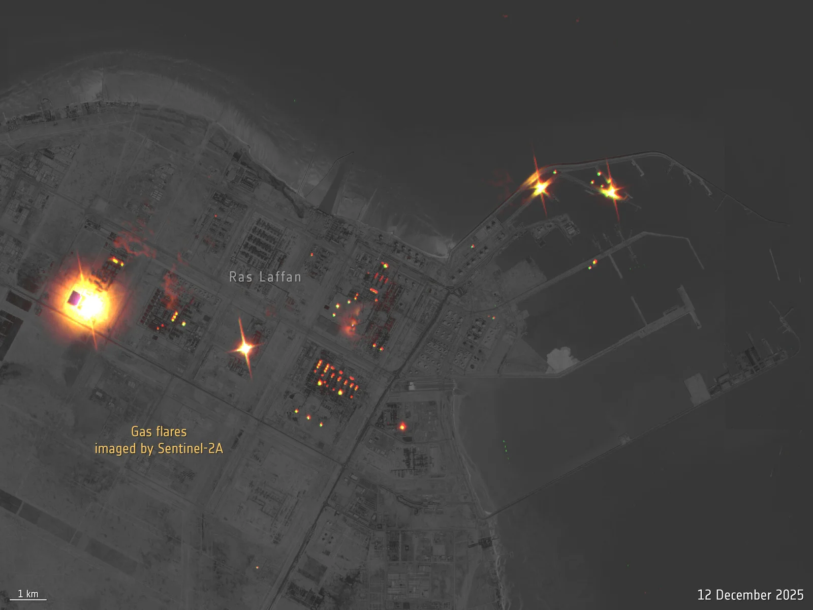
Tag

Earth Observation

All articles tagged with #earth observation

Sentinel-1D Debuts with Stunning Images Just 50 Hours Post-Launch

Originally Published 8 days ago — by The Daily Galaxy

Featured image for Sentinel-1D Debuts with Stunning Images Just 50 Hours Post-Launch
Source: The Daily Galaxy

Sentinel-1D, Europe's latest Earth observation satellite, achieved a record-breaking 50-hour turnaround from launch to first images, capturing high-resolution radar data of Antarctica, Europe, and maritime activity, demonstrating rapid response capabilities and advancing climate and environmental monitoring.

SpaceX Kicks Off 2026 with Multiple Satellite Launches and Sightings

Originally Published 9 days ago — by Spaceflight Now

SpaceX launched the Cosmo-SkyMed Second Generation Flight Model 3 satellite for Italy on January 2, 2026, using a Falcon 9 rocket from Vandenberg, marking the first Falcon launch in 16 days after previous delays. The satellite, designed for dual civilian and military Earth observation, will operate in a Sun-synchronous orbit and utilize synthetic aperture radar to capture images through clouds and darkness, enhancing Italy's defense and research capabilities.

Satellite Images Reveal the Secrets of the Eye of the Sahara

Originally Published 1 month ago — by The Daily Galaxy

Featured image for Satellite Images Reveal the Secrets of the Eye of the Sahara
Source: The Daily Galaxy

The 'Eye of the Sahara,' or Richat Structure, is a 50-kilometer-wide geological formation in Mauritania, visible from space and formed by ancient geological uplift and erosion. Recent satellite imagery from ESA reveals its layered sedimentary rocks, signs of erosion, and some desert life, providing valuable insights into Earth's geological history and ecosystem, showcasing ESA's role in Earth observation.

Ariane 6 Launches Sentinel-1D and Mysterious Sky Swirls Explored

Originally Published 2 months ago — by European Space Agency

Featured image for Ariane 6 Launches Sentinel-1D and Mysterious Sky Swirls Explored
Source: European Space Agency

Sentinel-1D, the last of the first-generation Sentinel-1 satellites, was successfully launched into orbit aboard an Ariane 6 rocket from French Guiana, completing the Copernicus Earth observation mission that provides critical radar data for environmental monitoring and disaster response.

Global Land Change Monitored Rapidly

Originally Published 3 months ago — by Nature

Featured image for Global Land Change Monitored Rapidly
Source: Nature

The article discusses DIST-ALERT, an operational satellite-based system that rapidly detects and monitors global land cover changes at 30m resolution using NASA and ESA satellite data, providing critical information for conservation, land management, and policy enforcement, with high accuracy and low latency since 2023.

Viewing the Planet from Both Above and Below

Originally Published 3 months ago — by National Geographic

Featured image for Viewing the Planet from Both Above and Below
Source: National Geographic

Photographers and astronauts Don Pettit and Babak Tafreshi collaborated to capture Earth from above and below, showcasing the planet's natural beauty and phenomena from the International Space Station and ground-based locations, highlighting the unique perspectives and the importance of human-led space photography.

Starlink Satellite Surprises with Photobomb of Chinese Military Site

Originally Published 3 months ago — by extremetech.com

Featured image for Starlink Satellite Surprises with Photobomb of Chinese Military Site
Source: extremetech.com

A high-resolution image captured by a Maxar satellite unexpectedly shows a SpaceX Starlink satellite passing over a Chinese military airbase, highlighting the increasing congestion in near-space and raising awareness about space domain complexities.

Satellite Captures New Images of Chinese Military Base

Originally Published 4 months ago — by PetaPixel

Featured image for Satellite Captures New Images of Chinese Military Base
Source: PetaPixel

A Maxar Technologies satellite captured an image of a passing SpaceX Starlink satellite over China's Dingxin Airbase, creating colorful reflections due to high relative speed, highlighting the increasing activity in near-Earth space and raising awareness about space debris and satellite visibility issues.

Starlink Satellites Disrupt Images of Chinese Military Installations

Originally Published 4 months ago — by Space

Featured image for Starlink Satellites Disrupt Images of Chinese Military Installations
Source: Space

A rare image captured by Maxar Technologies shows a SpaceX Starlink satellite passing over China's secret Dingxin Airbase, creating colorful reflections in the high-resolution photo, highlighting the increasing congestion in low Earth orbit and raising concerns about space sustainability and mission planning.