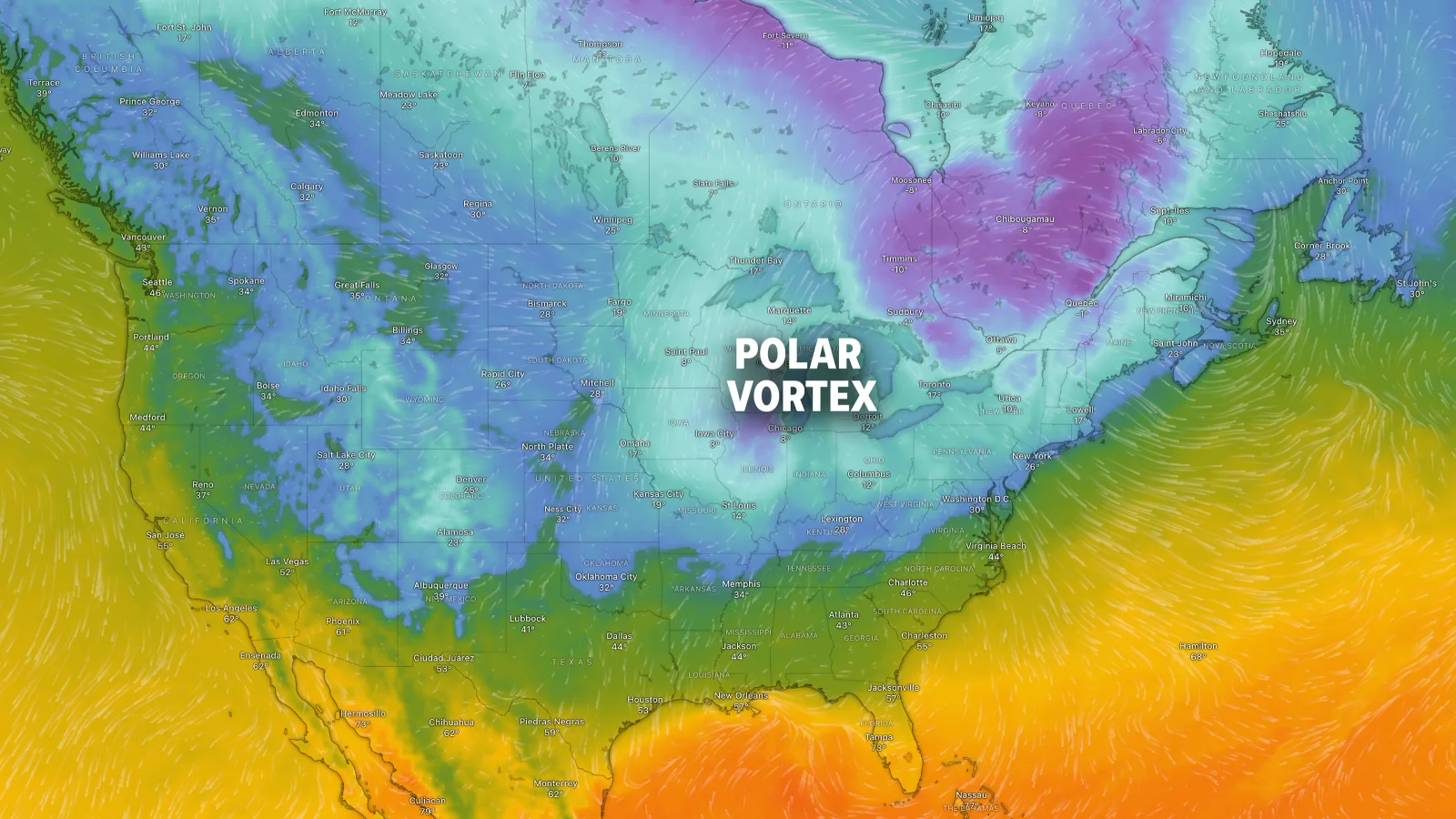
A triple-dip polar vortex is expected to bring frigid Arctic air to much of the central and eastern US over the coming weeks, causing significant cold surges, snow, and increased energy demands, with temperatures potentially dropping below -25°F in some areas.
A significant Arctic cold front is sweeping across much of the US, bringing snow, record low temperatures, and hazardous travel conditions, with Florida experiencing unseasonably cold wind chills and potential impacts on local wildlife like iguanas.
The northern lights may be visible across 18 US states on Monday due to a geomagnetic storm caused by a coronal mass ejection from the sun, with the best viewing times just after sunset or before sunrise, and the possibility of sightings even outside the direct viewline.
A severe heat dome is causing dangerous heat conditions for over 100 million people across the US, with high temperatures, humidity, and risk of heat-related illnesses, especially in the southeast and Tennessee Valley, while thunderstorms and wildfires also pose additional hazards.
The U.S. Northeast and Midwest are facing severe weather threats including heavy rainfall, flooding, and dangerous heat conditions, with multiple alerts issued across the regions. Climate change is contributing to increased frequency and intensity of such extreme weather events.
This article discusses the recent surge in flash floods across the U.S., driven by climate change-induced increased moisture and storm activity, with over 3,000 warnings issued this year, and highlights the quiet tropical Atlantic with no current storm development expected.
Tens of millions across the US face flash flood risks due to heavy, humid rain fueled by a stalled storm front, with areas from Virginia to the Midwest and Southwest experiencing potential record rainfall and flooding, exacerbated by climate change and recent wildfires.
A large cloud of Saharan dust is expected to reach the southeastern US this week, affecting air quality, visibility, and potentially reducing hurricane activity, while also possibly creating striking sunsets and warmer nights.
About 100 million Americans are under heat advisories as a severe heat wave continues, with temperatures reaching dangerous levels in the Mid-Atlantic states and other parts of the country. New York City and other major cities are experiencing record highs, and the heat index could exceed 100 degrees in several states. The heat wave is exacerbating air pollution and straining public infrastructure, with potential power outages and health risks. This extreme weather is part of a trend of increasingly frequent and intense heat waves due to climate change.
A recent study published in the Journal of Applied Meteorology and Climatology reveals that "Tornado Alley" in the U.S. is shifting eastwards, with increased tornado activity now impacting the Midwest and Southeast. The study, which analyzed data from 1951 to 2020, shows a significant decrease in tornadoes in the western U.S. and a rise in the eastern regions. Additionally, tornadoes are forming in colder weather, potentially linked to climate change.
An extreme 'heat dome' weather event is set to scorch parts of the US, including Florida, Texas, and Nevada, with temperatures soaring up to 111 degrees Fahrenheit. This phenomenon, which has already caused fatalities and environmental damage in Mexico, is expected to affect 7.7 million people and exacerbate health risks, wildfires, and droughts. The National Weather Service and experts urge residents to prepare for the dangerous heat, which is linked to climate change and is predicted to last through August.
The U.S. has experienced an unusually high number of tornadoes this spring, with at least 850 confirmed so far, making it one of the busiest years in recent history. Meteorologists attribute the increase to an active jet stream and warm, moist air from the Gulf of Mexico, influenced by a diminishing El Niño. The tornadoes have caused significant damage and fatalities, particularly in mobile homes, but have mostly spared densely populated areas. The role of climate change in this increased activity is still being studied.
More than 50 million Americans are under threat of severe storms, including tornadoes, flooding, and snowstorms, sweeping across central and eastern US on Easter Monday. Areas such as Fort Worth, Texas, face the risk of severe thunderstorms with potential for large hail and tornadoes. Other regions, including Oklahoma, Indiana, and New Hampshire, are also bracing for severe weather, with forecasts of heavy rain, hail, and possible tornadoes. The storms are expected to shift eastward on Tuesday, affecting cities like Memphis, Tennessee, Washington DC, and Baltimore.
Over 180 million Americans are expected to experience below-average temperatures as cold air and snow return to the US, with Freeze Watches and Warnings stretching from Arkansas to North Carolina. Heavy snow and dangerous snow squalls are forecasted for the Great Lakes region and central Appalachians, while the Southeast will see temperatures dip into the 20s and 30s. The Northeast will also face below-average temperatures, affecting more than 180 million people through Wednesday.
La Niña is expected to form this year, with a 62% chance of developing during the upcoming summer months, potentially worsening the Atlantic hurricane season by weakening wind shear and increasing storm activity. While its impact on U.S. summer weather is minimal, La Niña typically brings cold and snow to the Northwest and dry conditions to the southern tier during winter, with warmer temperatures in the Southeast and mid-Atlantic. The recent strong El Niño is weakening and expected to transition to "ENSO-neutral" conditions, with the entire El Niño/La Niña cycle known to affect weather in the U.S. and around the world.