A line of severe storms moved through central Indiana, bringing hail and damaging winds and prompting tornado watches for Marion County and nearby counties, with a confirmed tornado west of Bloomington and multiple tornado warnings in Morgan, Bartholomew, Johnson, and Shelby counties. After the system passes, cooler temperatures and a chance of Sunday snow are expected.
The National Weather Service’s Storm Prediction Center has issued an enhanced risk (Level 3 of 5) of severe weather across parts of the Ohio Valley today, with a potential for EF2+ tornadoes; the greatest risk is expected in southeast Illinois, southern Indiana and near the Ohio River.
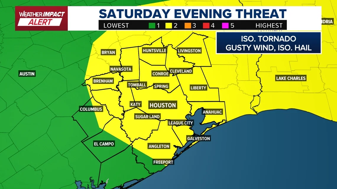
The Storm Prediction Center raised the Houston area to a Level 2 risk for severe weather on Saturday, triggering a Weather Impact Alert for the day. A line of storms could bring damaging winds and isolated tornadoes, with the most risk between 5 p.m. and 10 p.m. timing that could affect Mardi Gras and Valentine’s plans; downtown Houston may see storms around 8 p.m. and Galveston by 10 p.m. Sunday should clear, but the region remains drought-affected.
Governor Josh Green issued an Emergency Proclamation as a significant storm system threatens heavy rain, flash floods, and damaging winds across Hawaii, prompting statewide closures on Monday (state offices, DOE schools, UH campuses, Legislature, and courthouses) with administrative leave for state employees and extended filing deadlines to Tuesday; residents should prepare, sign up for local alerts, monitor HIEMA and NWS, and follow county guidance.
Portugal braces for storm Leonardo, expected to bring heavy rain, winds up to 95 km/h and waves over 11 metres, days after deadly Kristin; authorities urge residents to stockpile 72 hours of supplies and follow safety advice as orange alerts cover several districts and the Azores face red warnings, with the system sweeping across the country midweek.
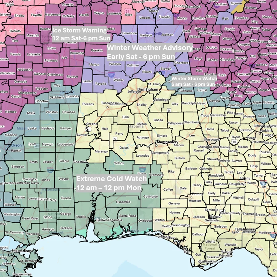
Alabama faces a multi‑part winter storm this weekend, with ice-storm warnings in Lauderdale, Colbert and Franklin counties, winter weather advisories and a watch near I-20. Precipitation arrives Saturday, bringing 2‑4 inches of liquid‑equivalent precipitation (higher in the north) and up to about 1 inch of freezing rain in the far north, while the southern half could see 1‑3 inches of rain. Freezing rain may mix with sleet north of I‑20 early, and snow is possible in the far northwest (up to about 1 inch) Sunday afternoon. A line of showers and thunderstorms with 40–60 mph gusts and a tornado risk could affect the southern half Sunday. Very cold air follows, with teens north to 20s elsewhere Monday, wind chills potentially as low as -3 in the north, and highs in the 20s–40s; Tuesday brings single digits north to teens south. Roadways could develop icy spots from any standing water.
A strong storm system in California is easing but still poses risks of mudslides, flooding, high surf, and avalanches, prompting evacuations and emergency responses across the state.
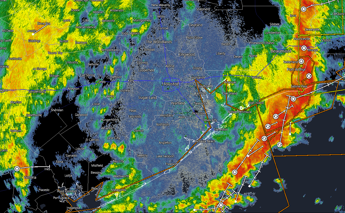
Houston experienced its first round of storms overnight, with scattered showers expected during the day and a second line of storms forecasted for Saturday night into early Sunday, bringing potential heavy rain, damaging winds, hail, and a slight tornado risk, followed by calmer, pleasant weather early next week.
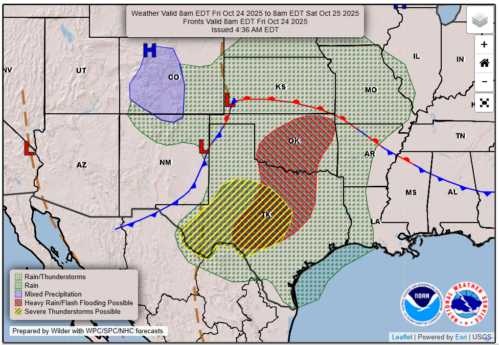
A significant storm system is expected to bring heavy rain, severe thunderstorms, and flood risks to Austin and Central Texas this weekend, after over a month without meaningful rain, with potential for damaging winds, tornadoes, and flash flooding, especially during overnight hours.
A powerful storm from Typhoon Halong caused severe flooding and destruction in western Alaska, notably lifting homes from their foundations and displacing thousands, with one man narrowly escaping death after his house floated away and was stopped just feet from the river by a small hill. Rescue efforts were extensive, and the storm resulted in at least one death and multiple homes damaged.
Travel chaos in the US with nearly 300 cancellations and over 4,400 delays caused by a combination of government shutdown staffing shortages and severe storms affecting major airlines and airports across the country, including Dallas, Nashville, and Minneapolis. Passengers are advised to stay updated, rebook if necessary, and prepare for extended wait times.
Severe flooding in western Alaska caused by Typhoon Halong has led to homes being washed away, with rescue efforts underway and multiple agencies involved in disaster response, as communities face significant damage and isolation.
A rare EF5 tornado with winds over 200 mph was confirmed in North Dakota, marking the first EF5 in the US in 12 years, causing fatalities and extensive damage, including destroyed farmsteads and uprooted trees.
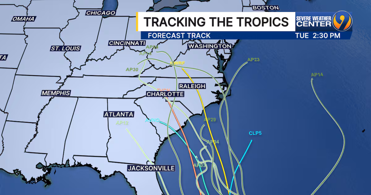
A developing tropical wave, Invest 94L, is strengthening near Hispaniola and may impact the Carolinas early next week with heavy rain, gusty winds, and severe weather, with potential landfall between Georgia and the Outer Banks, according to recent model guidance.
Severe weather, including a reported tornado, swept through Holden, Massachusetts, causing significant damage with fallen trees, debris, and disrupted daily life, prompting cleanup efforts and raising concerns among residents.