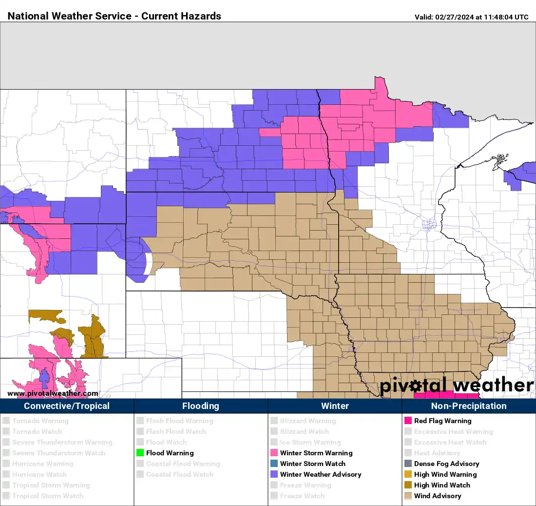
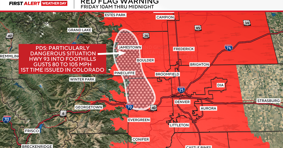
The National Weather Service in Colorado has issued a rare 'Particularly Dangerous Situation' for high fire danger due to strong winds, record warmth, and dry conditions, especially in the Foothills, with wind gusts up to 105 mph and temperatures breaking records, coupled with upcoming snowstorms in the high country.
Record-breaking warmth is expected on Monday with temperatures soaring 25 to 35 degrees above normal in Minnesota, leading to red flag warnings and an elevated fire risk in the southwest due to dry conditions and strong winds. Late-week moisture is possible with rain showers likely on Wednesday night and potential rain and snow showers on Friday into the weekend as temperatures gradually cool off to normal or below-normal readings.
The US experienced its warmest winter on record, leading to significant snow and ice deficits, worsening drought conditions in the Midwest, and a lack of cold air that shattered chances for prolonged, expansive ice coverage across the Great Lakes. The unusual warmth has had a serious impact on small businesses that rely on snow and winter tourism, prompting governors to encourage seeking federal assistance. This record warmth is another clear signal of the impact of human-caused planet-warming emissions on global temperatures.
A multiday blizzard is set to hit the Sierra Nevada, bringing heavy snow and winds of up to 100 mph, with snowfall rates of 1 to 2 inches per hour. Up to 10 feet of snow is expected in some areas, potentially erasing snowfall deficits and creating a surplus. Meanwhile, record warmth is forecast for areas east of the Rocky Mountains, with high temperatures climbing well above average and potential record highs in cities like Minneapolis and Chicago.
An analysis of 76 years of temperature data from about a mile above the ground reveals that the amount of cold air above the Northern Hemisphere this winter is near a record low, indicating the planet’s warming climate. The depleted cold-air supply has led to less vigorous blasts of Arctic air and more frequent and intense mild weather. This winter’s cold pool will finish as the second-smallest on record, continuing a trend of shrinking winter cold pools. The shrinking cold pool coincides with what is likely to be one of the warmest winters on record, with many locations in the United States experiencing record warmth. The dominance of upper-air warm extremes is consistent with heat records outpacing cold records, highlighting the impact of climate change.
Upstate New York is in for a rollercoaster of weather over the next few days, with potentially record-breaking warmth today and Wednesday followed by a strong cold front bringing damaging winds and a flash freeze. This will be succeeded by a blast of heavy lake effect snow in Central New York. High wind alerts have been issued, with gusts nearing 60 mph, and temperatures are expected to drop rapidly, raising the risk of a flash freeze. Thursday could see up to 8 inches of lake effect snow in some areas, making it potentially the snowiest day of the winter.
Minnesota is experiencing extreme weather changes, with heavy snow and plummeting temperatures expected Tuesday night, followed by record warmth over the weekend. Blizzard and winter storm warnings are in place for parts of the state, with snowfall accumulations ranging from a slushy coating in the south to several inches in the north. Temperatures will drop significantly, with frigid lows and subzero wind chills, before warming back up into the 30s, 40s, and potentially even low 50s, setting new record highs by the weekend.
February has seen above-average temperatures and little snow, with record warmth expected for Tuesday and Wednesday before a brief blast of colder air moves in late Wednesday through Thursday evening. This will bring a risk of regular and lake effect snow, with the potential for a flash freeze on Wednesday night. Gusty winds are also expected. Temperatures should rebound above average from Friday afternoon through next weekend.
After record warmth, Upstate New York is bracing for heavy snowfall, with the Catskills and eastern Southern Tier expecting a foot or more, while Albany could see 10 inches. The National Weather Service warns of blinding snow rates and has issued winter storm watches, with a 10% chance of Syracuse getting 10 inches. This comes after a notably low-snow winter, with just 28 inches in Syracuse, 60 inches less than normal, and temperatures dropping back to winter levels after hitting 60 degrees.
The region is expected to experience record warmth on Saturday with temperatures reaching the upper 50s to low 60s before a potential snowstorm early next week. A coastal storm is forecasted to bring heavy snow, with the potential for strong winds and coastal flooding. Colder air is expected to move in for the foreseeable future.
Record warmth is expected in the Hudson Valley on Saturday, with temperatures surging into the middle and upper 50s before a cold front brings a shift to colder weather. A potential winter storm is forecasted for Monday night into Tuesday, with significant snowfall possible for the region. The track of the storm is still uncertain, but there is growing confidence that the Hudson Valley will be impacted, with a 60% chance of significant snowfall and a 30% chance of seeing less than 3 inches. The Canadian model has also shifted to agree with other models, increasing confidence in the forecast.
After record-setting warmth, the Northeast is bracing for a potential nor'easter next week, with heavy rains, gusty winds, and plowable snow expected. Major cities like New York City, Philadelphia, and Boston are in play for accumulating snow, with the storm's exact track and strength being key factors. Gusty winds could lead to travel disruptions and reduced visibility along the I-95 corridor, potentially impacting some of the nation's busiest airports and roads.
Michigan is experiencing an unusual surge of record warmth, with temperatures expected to reach 60 degrees in several cities today and tomorrow, including Kalamazoo, Lansing, Flint, Saginaw, Bay City, Jackson, Ann Arbor, Monroe, and Detroit. Northern Michigan will also see record high temperatures, falling just short of 60 degrees. This unseasonably warm weather is expected to continue into Friday before returning to near-normal temperatures next week.
Michigan is set to experience a shift from dry, sunny weather to rain and potential snow from Thursday to Saturday, with the main form of precipitation being rain, especially in southern areas. While some snow may mix in, significant accumulations are not expected. Record warmth is expected to accompany the precipitation, with temperatures cooling down over the weekend. Rain is likely for most of the state, with no major flooding concerns, and a return to more normal temperatures is anticipated after the rainy system passes.
Michigan is set to experience record warmth over the next few days, with both high and low temperature records expected to be broken. Some cities may see temperatures up to 18 degrees warmer than normal, and the warm spell is expected to be widespread across the state. This unusual warm-up is a rare occurrence and is predicted to break records set over the past 125 years.