Minnesota faces continued wintry mix chances with a new system bringing rain or freezing rain, followed by a significant January thaw with temperatures rising into the 40s later in the week, reducing snowpack.
The weather forecast for Minnesota indicates cold temperatures below normal on Friday and Saturday with light snow, especially in northern regions. Milder air is expected to arrive early next week, bringing increased precipitation chances, including possible rain and snow mixes, with temperatures rising above freezing in southern Minnesota. The active pattern suggests continued winter weather through the weekend and into early next week.
The National Weather Service has issued an Ice Storm Warning for communities along the St. Lawrence River in New York, predicting up to 0.7 inches of ice accumulation and gusts up to 40 mph, with the most significant icing expected from late Sunday night to Monday morning, followed by lake effect snow.
A freezing rain storm is expected to impact the Tri-State Area on Sunday evening, with a First Alert Weather Day issued due to the risk of ice accumulation, especially in northwestern suburbs, potentially causing hazardous road conditions and power issues, but the event will be short-lived with rain replacing ice by Monday morning.
Maine is experiencing a cold Friday with wind chills in the negatives, followed by a quiet weekend with temperatures in the teens and low 30s, and a potential mixed precipitation event early next week, including snow and rain.
Philadelphia is unlikely to have a white Christmas, but a winter storm is expected Friday into Saturday, bringing 1-7 inches of snow and potentially impacting travel, with above-average temperatures and light showers on Christmas Day.
Atmospheric rivers are large plumes of moisture that form in tropical regions and are carried by winds to other areas, especially impacting the U.S. West Coast by causing heavy rain, snow, and potential flooding, with their size and frequency increasing due to climate change.
The Akron area is experiencing ongoing lake-effect snow with an additional 1 to 4 inches expected through Monday, along with cold temperatures and wind chills as low as -3°F, prompting travel advisories and caution due to hazardous road conditions.
Winter weather alerts have been issued for five counties in New Jersey, with Sussex County expecting 4 to 7 inches of snow and other counties receiving 1 to 5 inches, as a storm brings snow, sleet, and rain, impacting Tuesday's commute and followed by colder temperatures and potential additional snow later in the week.
A coastal storm is expected to bring 2 to 7 inches of snow to northwestern New Jersey, especially Sussex County, on Tuesday, with the possibility of heavy rain elsewhere in the state. Travel disruptions are anticipated, and the forecast remains uncertain due to storm track variations. Cold temperatures will follow the storm, with potential for additional winter weather next weekend.
The latest summer weather outlook for the US predicts above-average temperatures for much of the country, with varying precipitation levels. The emergence of La Niña is expected to influence weather patterns, potentially leading to significant heat waves and one of the warmest summers in history. While the Upper Midwest may see close to average temperatures, most regions are likely to experience above-normal rainfall, except for vast areas of the West. The neutral state of the El Niño-Southern Oscillation (ENSO) is also expected to impact temperatures and precipitation across the country.
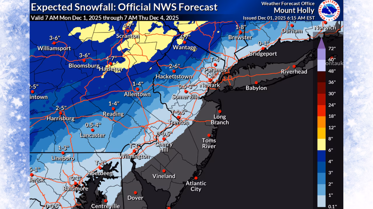
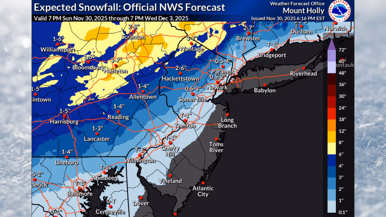
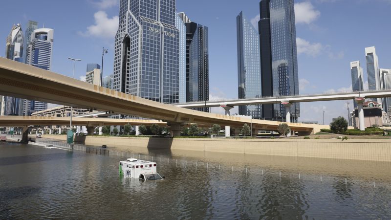
The recent flooding in Dubai has raised questions about the effectiveness of the United Arab Emirates' cloud-seeding program. Cloud seeding is a weather modification technique that aims to enhance precipitation by introducing particles into clouds. However, there is limited evidence of its success, and determining its impact on precipitation is challenging. As the world grapples with the effects of climate change, cloud seeding could potentially exacerbate water distribution issues. The recent flooding in the region was primarily driven by a large, slow-moving storm, regardless of whether cloud seeding occurred, and such extreme rainfall events are expected to become more frequent due to a warming atmosphere.
A nor'easter is battering Massachusetts and New Hampshire with heavy rain, sleet, snow, and wind, causing slippery conditions and coastal flooding, particularly in areas north of Boston through the Merrimack Valley, Cape Ann, and the Seacoast of New Hampshire. The high tide cycle from 7 a.m. to 8 a.m. poses the most significant risk for flooding in certain areas, with rain expected to linger after the nor'easter exits. However, warm weather is forecast for next week, just in time for the solar eclipse.
A long-duration storm system is expected to bring a mix of snow, rain, and sleet to Massachusetts, with Winter Storm Watches and Warnings issued for various areas. The storm will start with rain on Wednesday afternoon and evening, transitioning to sleet and then snow overnight into Thursday. Snow accumulation is expected in northern and western parts of the state, with potential for power outages due to heavy, wet snow and strong winds. Coastal flooding and beach erosion are also concerns, with the storm lingering through Friday and Saturday.