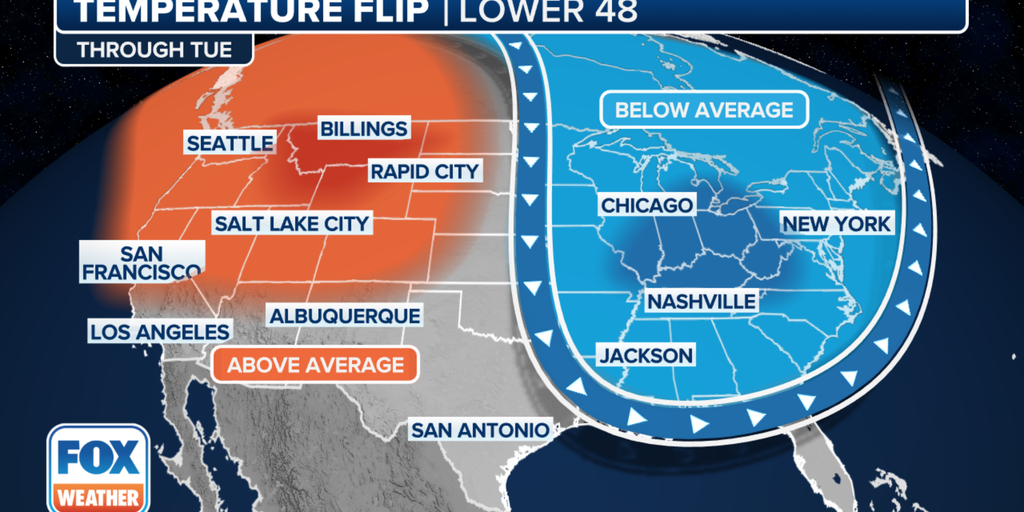
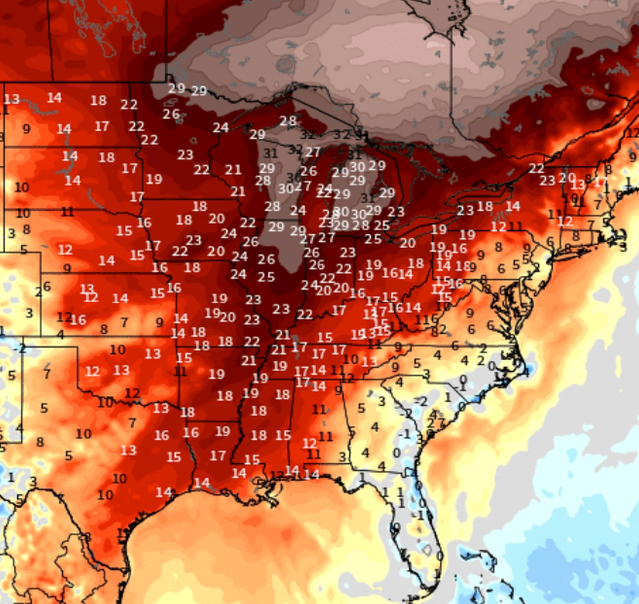
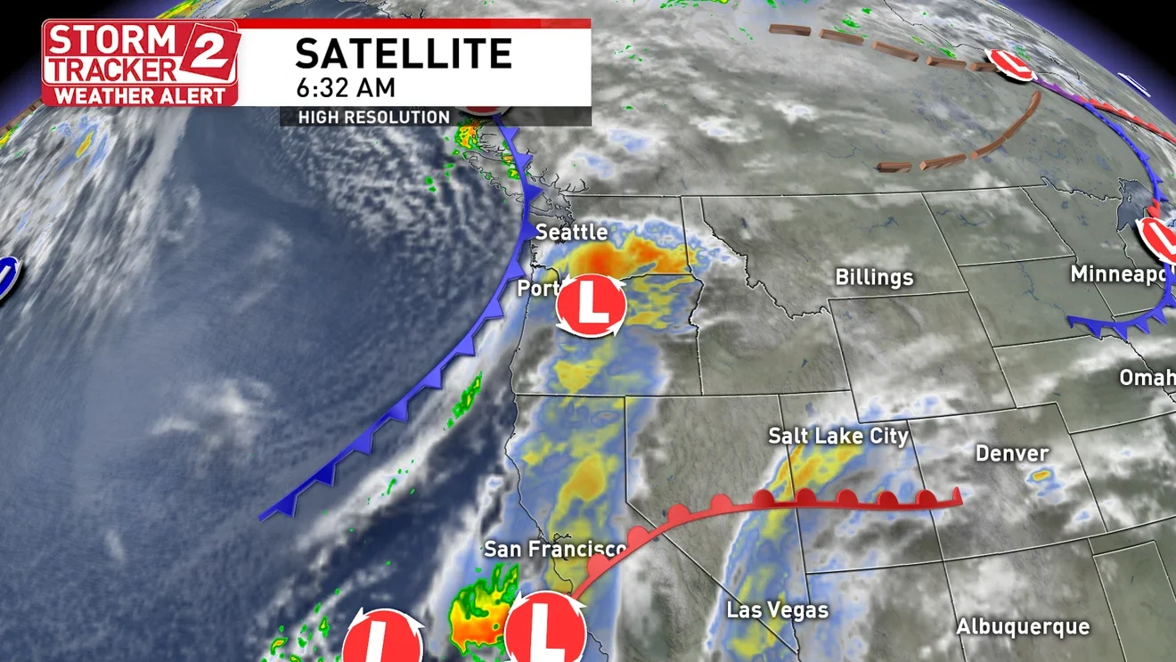
Tag

Cold Air

All articles tagged with #cold air

weather1 year ago

Thanksgiving Travel Alert: Winter Storm and Cold Snap Hit Northeast

A potential storm system could impact Upstate New York around Thanksgiving, with the possibility of rain or snow on Thursday and Friday, followed by cold air and lake effect snow over the weekend. Meteorologists are uncertain about the storm's path, urging travelers to stay updated. The region could experience its first significant winter temperatures, with highs barely reaching freezing and lows in the low 20s. The Great Lakes' warm, ice-free conditions could enhance lake effect snow if cold winds blow across them.

weather1 year ago

First Snowfall of the Season Hits Midwest and Northeast

A weather system is expected to bring a brief burst of wet snow to parts of Lower Michigan, particularly in the southwest and northern inland areas, late Wednesday night into Thursday morning. Despite warm ground and air temperatures slightly above freezing, cold upper-air may allow snow to accumulate 1-4 inches on grassy surfaces, with potential slush on roads. The snow is expected to melt quickly by Thursday evening, but drivers should be cautious of slick conditions during the snowfall.

weather1 year ago

"Spring Storms to Bring Heavy Snow and Severe Weather Across US Next Week"

A major early-spring storm is set to bring heavy snow, ice, and severe storms across the US this weekend into next week, affecting a wide area from the West to the Midwest and South. The storm will bring heavy snow to mountain ranges, moderate rain in major cities, and a severe storm threat with damaging winds, large hail, and potential tornadoes. Cold air from Canada will bring temperatures 10-30 degrees below average, with the chill expected to last through the end of the month across the western half of the country.

weather1 year ago

"US Braces for Winter Comeback: Cold Air and Snow Return"

Cold air from Canada will bring below-average temperatures and snow to more than half of the US on the final day of winter, with over 23 million people in the Southeast under freeze watches and warnings. Heavy snow, including lake-effect snow, is expected from the Great Lakes to the Northeast and central Appalachians. A potent low-pressure system moving across Canada will aid in developing lake-effect snow and dangerous snow squalls in the Great Lakes region. The cold front will push south across the Southeast, bringing much colder air and the potential for frost/freeze damage to vegetation. Warmer air will slowly return as spring begins, but millions will feel the late-season winter chill on Monday.

weather1 year ago

"180 Million Americans Brace for Winter's Return as Cold Air Sweeps Across the US"

Over 180 million Americans are expected to experience below-average temperatures as cold air from Canada brings late-season winter weather to more than half of the US, with Freeze Watches and Warnings in the Southeast and heavy snow affecting the Great Lakes and Northeast. The cold front will push south, bringing very cold temperatures to the Southeast, Midwest, and Northeast, potentially causing damage to sensitive plants. Warmer air will gradually return as spring officially begins, but over 150 million people will still feel the chill on Tuesday, and nearly 90 million will remain below average on Wednesday.

weather1 year ago

"Millions of Americans Brace for Below-Average Winter Temperatures and Snowfall"

Over 180 million Americans are expected to experience below-average temperatures as cold air and snow return to the US, with Freeze Watches and Warnings stretching from Arkansas to North Carolina. Heavy snow and dangerous snow squalls are forecasted for the Great Lakes region and central Appalachians, while the Southeast will see temperatures dip into the 20s and 30s. The Northeast will also face below-average temperatures, affecting more than 180 million people through Wednesday.

weather1 year ago

"Chilly Weekend Forecast: Lake-Effect Snow, Gusty Winds, and Cooler Temperatures Ahead"

Cold air moving into Michigan will bring lake-effect snow showers from Sunday through Tuesday, with accumulations expected in the northern U.P., northwest Lower Michigan, southwest Lower Michigan, and the Thumb. The snowfall forecast through Tuesday evening includes up to 8 inches in the U.P., 2-4 inches in northwest Lower Michigan, and 1-2 inches in the Thumb and northeast Detroit area. The lighter accumulations will be temporary due to the warm ground, with melting expected once the snow stops.

climate-change1 year ago

"Record Low: Frigid Winter Air Shrinking"

An analysis of 76 years of temperature data from about a mile above the ground reveals that the amount of cold air above the Northern Hemisphere this winter is near a record low, indicating the planet’s warming climate. The depleted cold-air supply has led to less vigorous blasts of Arctic air and more frequent and intense mild weather. This winter’s cold pool will finish as the second-smallest on record, continuing a trend of shrinking winter cold pools. The shrinking cold pool coincides with what is likely to be one of the warmest winters on record, with many locations in the United States experiencing record warmth. The dominance of upper-air warm extremes is consistent with heat records outpacing cold records, highlighting the impact of climate change.

weather1 year ago

"Snowy Presidents' Day Weekend Forecast for D.C.-Area"

The D.C.-area forecast includes mainly sunny and breezy conditions today, with a chance of snow on Friday night, potentially leading to a picturesque Saturday. Highs will range from the upper 40s to lower 50s today, with gusty winds persisting tonight. Tomorrow will start sunny but clouds will increase in the afternoon as a storm approaches, bringing colder air and the likelihood of snow, with accumulations ranging from a coating to a few inches. The cold air will linger through the weekend, with mainly sunny conditions and highs in the upper 30s to lower 40s.

weather1 year ago

"Expert Predicts Return of Cold Air and Unsettled Weather for February"

Researcher Judah Cohen, who studies the polar vortex, predicts a "polar vortex disruption" around mid-February, potentially leading to a return of cold air to the eastern U.S., including Michigan. His forecast suggests below-normal temperatures for the second half of February, possibly extending into the first two weeks of March. This pattern of a mild winter followed by wintry conditions in March has been common in the past decade, but the increasing heating power of the sun indicates that spring will eventually prevail.

weather1 year ago

Michigan's Unseasonably Warm February Weather Outlook

Michigan is set to experience an extremely warm week in early February, with temperatures climbing into the 40s and 50s, a rare occurrence for this time of year. Factors such as morning fog burning off, sunshine, and a southwest wind from Oklahoma and Texas will contribute to the warmth. However, colder air is expected to return between February 14 and 16, bringing temperatures back to normal for the end of the month.

weather2 years ago

"Iowa Hit by Snow and Dangerous Wind Chills"

Thursday's snowfall in Iowa pushed Des Moines' 10-day total to more than 2 feet, with various cities receiving between 2.5 to 4.5 inches of snow. The cold air is expected to persist, with temperatures remaining well below zero and wind chills making it feel even colder. However, a warm-up is anticipated for Sunday, with temperatures climbing into the 30s.

weather2 years ago

"Northwest Braces for Winter Storm with Snow, Ice, and Cold Air"

Cold arctic air has arrived in the metro area, bringing flurries and drizzly spots. A snow and ice storm is expected to arrive on Saturday morning, with the forecast predicting 1-6 inches of snowfall from Salem through the metro area and north to Longview, accompanied by ice pellets and freezing rain. The storm is expected to bring the coldest and windiest day Portland has experienced in three decades, with potential power outages and blowing snow in certain areas. The precipitation is expected to end on Sunday, but freezing temperatures and icy conditions will persist through Monday.

weather2 years ago

"Northwest Braces for Winter Storm with Snow, High Winds, and Mountain Pass Closures"

A winter storm watch has been issued for the Portland metro area from Friday to Saturday afternoon, with forecasts predicting 1-6 inches of snow. Uncertainties remain regarding the exact type of winter weather due to factors such as microscale meteorology and the movement of cold air. East winds are expected to bring cold air into the region, potentially leading to snow or ice depending on the depth of the cold air and the movement of moisture. The situation is still developing, and the Portland area is likely to experience some of the coldest temperatures of the season.

weather2 years ago

"Blizzard Warning: Puget Sound and Northwest Bracing for Snow and Low Visibility"

Lowland snow is possible for the Puget Sound area in the coming days following a winter storm, with a mix of rain and wet snow expected on Wednesday and the potential for scattered snow showers on Thursday and Friday. Cold air will move into the region, but the precipitation is forecasted to be hit-and-miss, making widespread snow unlikely. However, select sea-level locations may see one to four inches of snow by Friday, with the possibility of heavier snowfall in certain areas. Another round of precipitation is expected on Saturday, but its impact remains uncertain at this time.