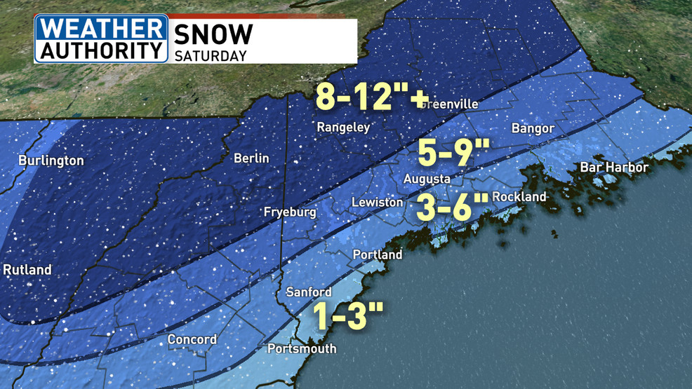
Maine is bracing for a cold and windy Thursday, with heavy snow expected on Saturday, particularly in the mountains where a foot or more is possible. Coastal areas may see a few inches before a change to rain. The storm will start as all snow before sunrise on Saturday, with potential mixing along the coast. Uncertainty remains regarding the inland extent of the mixing line. Quieter weather is expected for Maine Maple Sunday, with temperatures in the upper 30s, but rain chances may return by Tuesday-Wednesday.
Tuesday will be windy and briefly warmer in Minnesota before temperatures drop again, with snow expected to develop on Thursday and over the weekend. Blustery northwest winds will bring in colder air, with lows falling into the single digits and teens on Tuesday night. Wind chill values early Wednesday will be frigid, and highs on Wednesday will be back below normal. A wide swath of snowfall accumulation is expected across central and southeast Minnesota, with potentially more significant snow and a mix of precipitation over the weekend, including the possibility of heavy snow and rain/sleet mix. Temperatures are expected to remain below normal into next week.
The D.C.-area forecast includes windy conditions today, with gusts up to 40-50 mph, before a significant warm-up later in the week. Temperatures are expected to rise well into the 60s on Tuesday, reaching the 70s and possibly even 80 on Friday. The region will experience mostly dry weather, with the potential for showers on Friday into Saturday. Overall, the week will be characterized by windy conditions giving way to sunny and warm spring weather, before a return to chillier temperatures next week.
Dense fog this morning will clear, followed by heavy rain and thunderstorms overnight into Saturday morning, with the potential for strong to severe storms. Saturday afternoon will be nicer, while Sunday will be windy and cooler. Cooler temperatures will continue into early next week, with a warm-up and more rain expected later in the week.
The D.C.-area is set to experience frigid temperatures and windy conditions through the weekend, with highs struggling to reach the 20s and wind chills making it feel even colder. Despite some sunshine, the cold weather is expected to persist, with temperatures gradually rising next week. Snow accumulation is not expected in the near future, providing a welcome break after recent snowy conditions.
Southeast Wisconsin is expected to experience blizzard conditions by evening as snow intensifies throughout the morning, with temperatures dropping and snow becoming light and fluffy. Accumulations of 8-12 inches of snow are expected inland, with higher amounts possible due to lake enhancement, while areas along the coast may see 5-8 inches of wetter snow. Very cold temperatures and windy conditions are anticipated through the weekend, with wind chills near 20 below zero.
The D.C.-area forecast indicates a drying out today with a gusty breeze and mild temperatures, followed by a mostly sunny and mild Thursday. The next storm is expected to bring rain late Friday into Friday night, followed by a colder weekend with gusty winds. Saturday and Sunday are forecasted to be partly to mostly sunny and windy, with temperatures in the 40s and a possibility of snow on MLK Monday.
Southeastern Wisconsin will experience mostly cloudy skies with temperatures in the low to mid 30s, with the possibility of more snow tonight and Friday night. A clipper system is expected to bring light snow tonight, followed by another impactful system on Friday into Saturday morning, potentially bringing several inches of snow and strong winds. The region will also experience very cold temperatures on Sunday into early next week.
A series of storm systems will bring snow and much colder temperatures to Denver, with strong winds expected on Wednesday. Snow and cold temperatures are forecasted for the mountains, while the plains will experience sunny conditions with passing clouds. Light snow is expected from Thursday to Monday, with the coldest temperatures of the season arriving on Saturday and sticking around until Tuesday.
A strong storm system and cold front will bring widespread severe weather to much of the U.S. east of the Rockies, including Northeast Florida and Southeast Georgia. Locally, windy conditions are expected with the potential for damaging winds, isolated tornadoes, hail, and heavy rain in the afternoon. Gusty winds will continue into Tuesday night, and there is a possibility of isolated severe storms ahead of the main line. This storm will also produce a snowstorm for the Midwest and flooding along the East Coast and Northeast U.S., making it the biggest and strongest storm of the winter so far.
Weather alert days have been issued for this weekend due to an approaching storm, with heavy rain and isolated strong storms expected. Coastal erosion and 12-foot waves are possible at beaches, and the winds will shift from the northwest, bringing colder air for next week.
A powerful rainstorm with strong winds is expected to hit Eastern Massachusetts on Monday, causing a messy morning commute. The storm, known as an "inside runner," will bring warm air and over 2 inches of rain to the region. Wind gusts of up to 65 mph are forecasted, which could lead to power outages and downed trees. Heavy rain may cause street flooding and poor drainage. The exact timing and track of the storm are still uncertain, but there is a possibility of coastal flooding and scattered power outages.
Chicago is expected to experience cold and snowy weather this Halloween, with temperatures in the 20s and 30s and wind chills in the teens and 20s. A freeze warning is in effect, and snow showers are predicted to develop on Tuesday, potentially causing slick travel conditions. Wind gusts of up to 45 mph and reduced visibility are also expected. Snow totals are not expected to be significant in Illinois, but Northwest Indiana could see over two inches. However, temperatures are expected to rise back into the upper 50s by the end of the week.
A passing shower is expected this evening, followed by a cool and windy weekend. Temperatures will range from the low to mid-60s, with winds sustained around 20 mph and gusts near 40 mph. Showers are possible at night, but Sunday should be mostly sunny with temperatures in the low 60s.
Showers, including a few downpours, are expected to continue into the evening before easing by dawn. There is a possibility of morning sprinkles or drizzle on Sunday, but skies should start clearing and winds will pick up. Temperatures will be in the upper 50s to low 60s with gusty north-northwest winds. Overnight, skies may clear with low temperatures in the low to mid-40s.