Tag

Snow Showers

All articles tagged with #snow showers

weather1 year ago

Michigan Braces for Heavy Snowfall and Slick Roads Amid Winter Storm

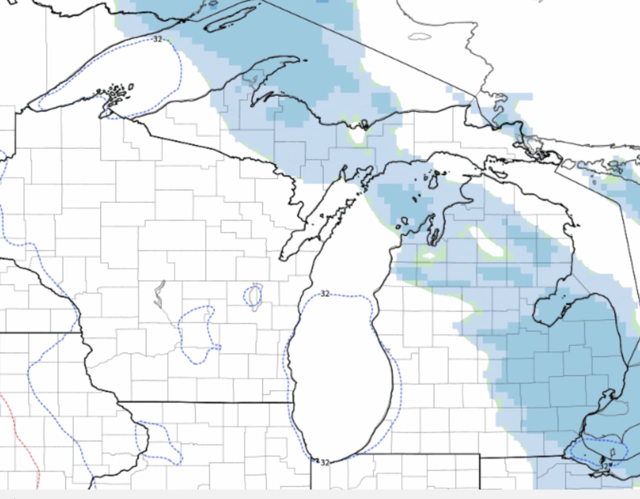
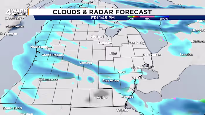
Southeast Michigan is experiencing blustery and snowy conditions on Black Friday, with snow showers expected to be more persistent south of M-59 and along the I-94 corridor. Ann Arbor could see up to an inch of snow, while Detroit may receive up to half an inch. Drivers should be cautious of slick roads and reduced visibility, especially on bridges and ramps. Wind chill values will remain in the teens due to breezy conditions, with westerly winds gusting up to 30 mph. Cold weather is expected to continue into the first week of December.

weather1 year ago

"Chilly Weekend Forecast: Lake-Effect Snow, Gusty Winds, and Cooler Temperatures Ahead"

Cold air moving into Michigan will bring lake-effect snow showers from Sunday through Tuesday, with accumulations expected in the northern U.P., northwest Lower Michigan, southwest Lower Michigan, and the Thumb. The snowfall forecast through Tuesday evening includes up to 8 inches in the U.P., 2-4 inches in northwest Lower Michigan, and 1-2 inches in the Thumb and northeast Detroit area. The lighter accumulations will be temporary due to the warm ground, with melting expected once the snow stops.

weather1 year ago

"Winter Weather Update: Snow Showers Hit Portland Metro and Cascades, Cold and Wet Forecast Continues"

Snow showers are expected to continue overnight in Portland, with little accumulation expected in the area, while the Coast Range and Cascade foothills are forecasted to receive between two to seven inches of snow. A Winter Weather Advisory is in place for these areas, with temperatures dropping to 33 degrees in Portland and the snow level dropping to 500 feet overnight. The snow is expected to turn to rain showers by the afternoon, with temperatures reaching a high of 44 degrees. Drier conditions are anticipated by Tuesday, with high temperatures reaching the 50s by the end of the week.

weather1 year ago

"Northeast Winter Weather Update: Snow Forecast Shifts, Coastal Flooding Expected"

A storm passing by southern New Hampshire is bringing light snow showers to the region and a potential for coastal flooding, with a coastal flood advisory in effect for Tuesday afternoon. Snow showers are expected to be minimal, with just a dusting to an inch or two in southern areas, and minimal impacts in the northern half of the state. Partial clearing is expected Tuesday night, with windy conditions and a chance of light snow on Valentine's Day and Thursday night into Friday morning.

weather1 year ago

"Winter Returns: Snow Forecast for Upstate NY and Rochester Region"

After a mild start to the week, temperatures will drop, bringing a more wintry feel to central New York. While a nor'easter will miss the area, it will still bring some snow to parts of upstate New York. Colder air behind the storm will lead to lake effect snow showers on Tuesday evening into Wednesday morning, with the potential for 1-3 inches of snow. There's also a chance for snow on Thursday night into Friday and possibly on Saturday.

weather2 years ago

"Weekend Forecast: Dangerous Cold and Icy Mix Ahead"

Blustery conditions and low clouds are decreasing into sunset, with wind chills as low as zero degrees possible tonight and continued cold and blustery conditions expected for Sunday. Temperatures will bottom out in the teens tonight, with wind gusts easing toward 20 mph by dawn. Sunday will be mainly sunny with early wind chills around zero, slowly warming above 20 degrees late day. Snow lovers are looking ahead to Presidents’ Day, as a warmer temperature trend is expected over the next 10 days, but confidence is low.

weather2 years ago

"Extreme Cold Alert: Sioux City Braces for Record-Breaking Wind Chills and Near-Record Low Temperatures"

Snow showers are expected to continue into the evening, adding to the existing snowpack, with very cold conditions and wicked wind chills expected tonight through Saturday. Saturday will be bright but cold with highs in the mid-20s and gusts of 30 to 35 mph, leading to wind chills in the single digits to around 10 degrees. Sunday will be sun-filled but still chilly, with highs in the upper 20s and lower 30s and gusty winds continuing.

weather2 years ago

"Multiple Winter Storm Watches and Arctic Blast Bring Icy Conditions and Snow to Ohio"

A Winter Storm Watch will be in effect in several Northeast Ohio counties starting at 1 a.m. Friday, with gusty winds and temperatures around 20 degrees leading to single-digit wind chills. Snow showers are expected on Thursday, potentially causing a slippery morning commute with 1-3 inches possible in northern communities and a dusting to 1 inch for most areas. More widespread snow showers are forecast for Friday, with the possibility of several inches accumulating by the weekend. Cold weather is expected to persist until early next week, with highs in the 30s and 40s.

weather2 years ago

"Pittsburgh Braces for Snow Impact, Sub-Zero Wind Chills"

A wind chill advisory has been issued for Pittsburgh from 10 p.m. tonight through noon Wednesday, with wind chill values expected to be between -5 and -8 on Wednesday morning. The snow showers have tapered off, but cold temperatures will persist, with highs only reaching the low 20s on Wednesday. Another round of snow showers is possible late Thursday and into Friday, as cold air remains through the weekend.

weather2 years ago

"Northeast Ohio Braces for Bitter Cold and School Closures Due to Frigid Wind Chills"

Bitter cold temperatures continue in Columbus, Ohio with wind chills well-below zero, prompting Weather Alert Days on Wednesday and Friday. Snow showers are expected on Thursday and Friday, with accumulations of 1-2 inches possible. Wind chills will be well-below zero on Saturday and Sunday mornings. Temperatures are expected to moderate by Monday, reaching the mid-30s, and climb into the 40s by Tuesday with rain melting off the snowpack.

weather2 years ago

"Arctic Blast Blankets US and Canada with Record-breaking Cold"

Subzero wind chills and frostbite warnings persist in Cleveland for the next 24 hours, with temperatures remaining in the teens and lows dipping into single digits. Scattered snow showers are expected late tonight through early Tuesday, with a dusting to 2 inches at most. The next chance for snow will be late Thursday into Friday, followed by lake effect snow on Saturday. Temperatures are expected to remain below average, with the cold spell lasting until early next week.

weather2 years ago

"Chilling Snowfall Blankets Western Washington Lowlands"

Western Washington is experiencing a brutal freeze with record low temperatures and strong winds, resulting in wind chill readings as low as -17°F in some areas. Flurries and light snow showers are expected, with the cold stretch being the coldest in years. The region is bracing for dangerously cold weather and wind chill overnight and into tomorrow, with Seattle's forecasted morning low of 15°F on Saturday being the coldest since 2010.

weather2 years ago

"Upcoming Weather: Rain, Snow, and Plunging Temperatures with Strong Winds"

A potent storm is bringing rain and gusty winds on Friday, followed by plunging temperatures and snow showers on Saturday. A wind advisory is in effect until 8 a.m. Saturday, with winds picking up to 45-50 mph gusts. Another 1-2 inches of rain combined with the winds could lead to power interruptions. Cold air will persist into Sunday, with temperatures possibly not reaching the teens. The harsh winter weather may last into next week, with wind chills at or below zero on MLK Day Monday and the possibility of light snow showers.

weather2 years ago

"Forecast: High Winds and Subzero Chills Grip Ohio Region"

Northeast Ohio is bracing for blustery winds, bitter cold temperatures, and low visibility conditions this weekend, with a High Wind Warning and Wind Advisory issued for several counties. Expect wind gusts exceeding 40 mph, light to moderate snow showers on Saturday, and subzero wind chills with temperatures in the teens for several days. Bundle up and stay updated with the latest forecast.