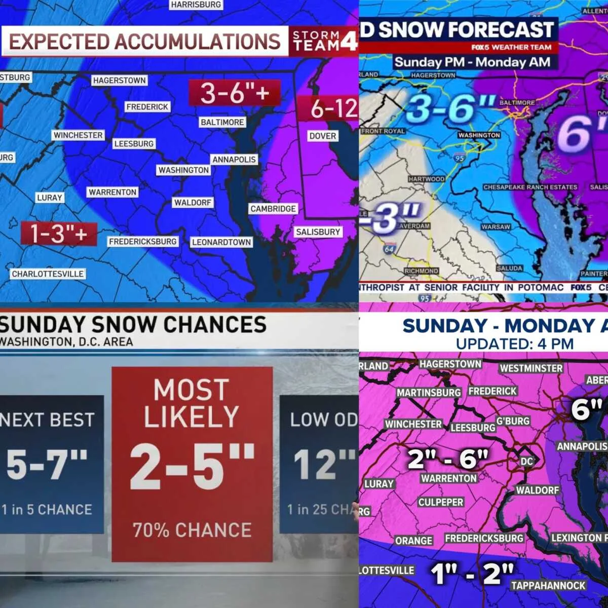
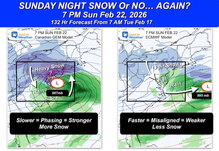
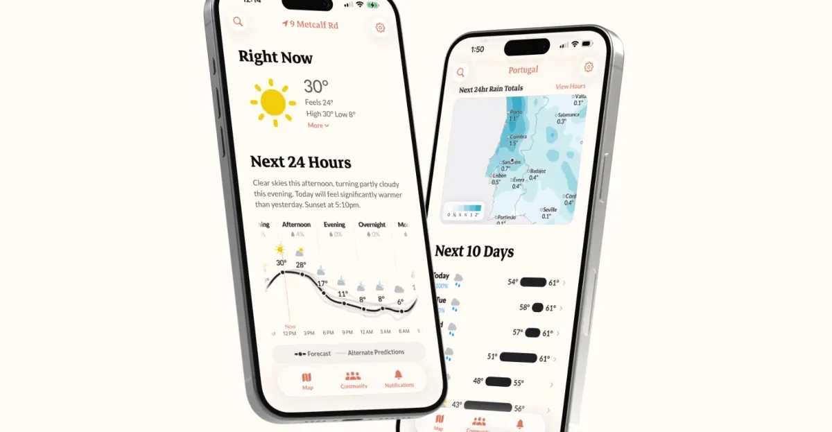
Central Texas experienced a cooler Saturday with highs in the 50s and gusty winds, and temperatures dropping to the 20s and 30s overnight, with a freeze in the Hill Country. The weather will warm slightly next week with highs in the 50s and 60s, but a series of cold fronts are expected mid-week and next weekend, bringing isolated showers and additional cold air. Stay updated with local weather alerts and forecasts.
A mostly cloudy Saturday with ending flurries gives way to a wintry mix on Sunday in Minnesota, with potential freezing rain, sleet, and snow, especially along the North Shore, as a storm system approaches. Temperatures will rise into the upper 30s and 40s, reducing snow depth by week's end.
The weather forecast for Minnesota indicates cold temperatures below normal on Friday and Saturday with light snow, especially in northern regions. Milder air is expected to arrive early next week, bringing increased precipitation chances, including possible rain and snow mixes, with temperatures rising above freezing in southern Minnesota. The active pattern suggests continued winter weather through the weekend and into early next week.
A weather system brings light snow and colder temperatures to Minnesota on Wednesday, with snow showers ending by early afternoon and temperatures dropping into the teens and single digits, but warming up to seasonable levels by the weekend.
Light snow and flurries are possible overnight and on New Year's Day in the DC area, with cold temperatures hovering around freezing, but little to no accumulation is expected, making for potentially icy roads and a chilly start to 2026.
Dallas is experiencing a brief winter cold snap, but temperatures will quickly warm up into the 60s and 70s for the New Year's holiday, with a trend towards even warmer weather into early next week, reaching near 80 degrees, before a potential storm system later in the week.
A cold week in Minnesota with snow showers expected Tuesday and Wednesday, following a recent storm that brought over 5 inches of snow to the Twin Cities. Temperatures will briefly rise on Tuesday before dropping again, with Arctic air moving in to make for a frigid start to 2026.
A light wintry mix is ending tonight in Central Texas, with temperatures warming up significantly starting Tuesday, leading to a mild New Year's Eve and a warm start to 2023, with only a weak cold front expected early next week.
A warm weekend in Austin with highs in the 70s and 80s will be followed by a strong cold front Sunday evening, bringing gusty winds, a chance of limited rain, and a return to winter-like temperatures on Monday with highs in the 40s and 50s, and potential freezing lows early next week.
The weather forecast for Minnesota predicts very mild temperatures through Saturday, with highs in the 40s and 50s, followed by a cold front arriving Sunday bringing falling temperatures into the teens and snow showers, especially in eastern Minnesota, with a potential for several inches of snow. Temperatures will then rebound into the 20s and 30s early next week, with a possible active weather pattern including additional snow chances midweek.
Austin experienced near-record warmth with highs in the 80s, but a strong cold front arriving late Sunday will bring winter air, gusty winds, and a drop in temperatures into the 40s and 50s, with potential for freezing temperatures Tuesday morning.
Temperatures in Minnesota will be slightly cooler on Tuesday but remain above normal, with ongoing melting through the week. A stalled cold front causes a contrast in temperatures across the state, and milder weather is expected to continue into Christmas. Weather patterns influenced by a wet West Coast and a wavy jet stream keep the region milder than usual, though colder air is expected to arrive by the weekend, bringing snow and lower temperatures.
A brief and potentially strong windstorm in the I-5 corridor on Christmas Eve is possible due to specific low pressure conditions, but forecasts are uncertain and it may be canceled within 24 hours, so residents should stay alert.
NYC's winter snowfall is expected to be below average this season due to a weak La Niña, with forecasts predicting 15-20 inches of snow, which is less than the 30-year average of nearly 30 inches, though a significant snowstorm cannot be ruled out.
A warm Tuesday with temperatures reaching into the 40s in Minnesota will be followed by a system bringing rain and snow late Wednesday into Thursday, with colder air arriving afterward and significant snowfall expected in northern Minnesota.