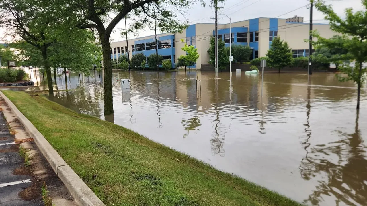
Southeast Wisconsin experienced severe flash flooding from Saturday night into Sunday morning due to heavy rainfall, prompting flood warnings and advisories, with more rain expected.
Southeast Wisconsin is expecting two rounds of storms today, with the potential for severe weather including gusty winds, hail, and isolated tornadoes. The first round will hit late morning to early afternoon, and the second round could occur in the evening if the atmosphere recovers. Sunshine returns on Saturday, but more showers and storms are expected on Sunday and possibly into Memorial Day.
Southeast Wisconsin is expecting rainy and snowy weather, with rain showers and possible snow on Tuesday and Wednesday. Temperatures will be in the low to mid 40s, with strong winds gusting over 40 mph on Wednesday. Some snow accumulation is expected, especially on grassy surfaces and possibly on roadways. After the system passes, temperatures are expected to climb towards the 50s and even reach the 60s next week.
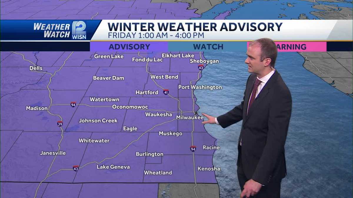
The National Weather Service has issued a winter weather advisory for southeastern Wisconsin from 1 a.m. to 4 p.m. on Friday, with snowfall expected to impact the entire area, especially the Interstate 94 corridor, where 3-6 inches of snow are likely. Residents in various cities should prepare for snow to begin falling after midnight, impacting travel, particularly during the morning commute. There is uncertainty about where higher accumulations will occur, and there is potential for light snow switching to rain on Sunday and early next week.
A Winter Weather Advisory is in effect for all of southeastern Wisconsin on Friday morning as snow is expected to move in late tonight and into Friday morning, with 3-6 inches of wet snowfall accumulation predicted for most of southern Wisconsin. The snow is likely to impact the Friday morning commute, with snowfall expected to wrap up early Friday afternoon. Sunshine is forecasted for Saturday before another round of rain/snow moves in late Sunday and into Monday.
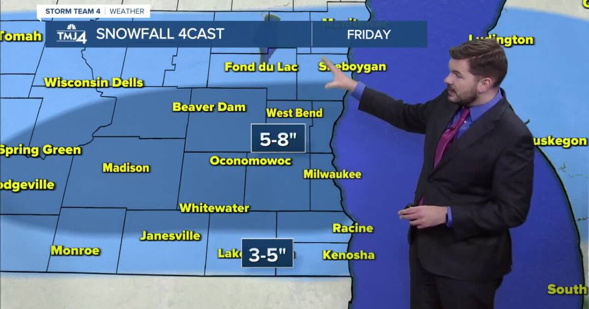
A winter storm warning has been issued for Southeast Wisconsin from Friday at 6 a.m. to Saturday at 12 p.m., with snow accumulation of 3 to 7 inches along the lakeshore and 6 to 10 inches farther inland, accompanied by gusty winds. Several school districts, including Milwaukee Public Schools, have announced closures for Friday due to the expected weather conditions. Residents are advised to stay updated on the latest weather alerts and closures.
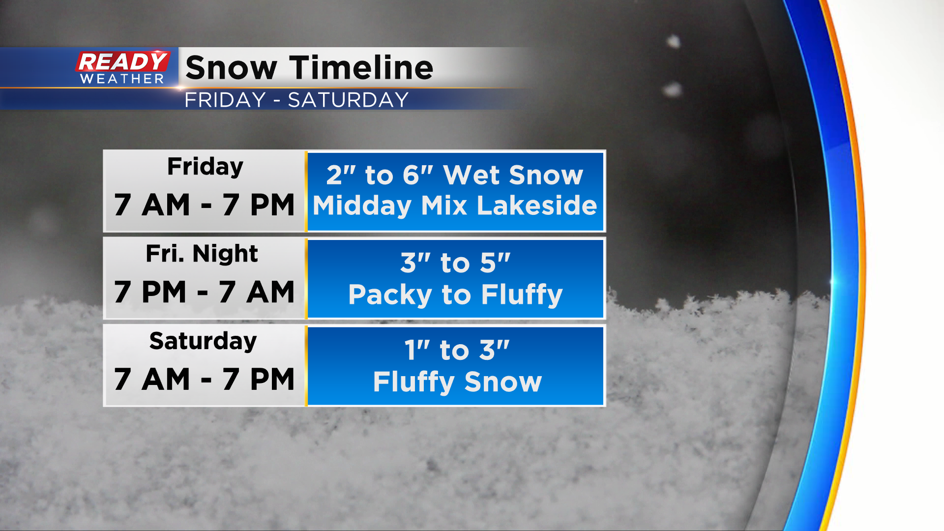
A Winter Storm Warning has been issued for southeast Wisconsin from 6am Friday to noon Saturday, with snow moving in and potentially reaching moderate to heavy rates. Lighter snow and rain may mix in midday, changing to snow by early evening with colder air and northeast winds creating lake enhancement and higher snowfall rates. Wet and packy snow on Friday will transition to fluffy snow by Saturday morning, with total snowfall expected to be 7-11 inches for most of SE WI and possibly over 12 inches near the Kettle Moraine. Blowing and drifting snow will be a concern on Saturday, and updates can be found on the CBS 58 Ready Weather App.
Southeastern Wisconsin will experience mostly cloudy skies with temperatures in the low to mid 30s, with the possibility of more snow tonight and Friday night. A clipper system is expected to bring light snow tonight, followed by another impactful system on Friday into Saturday morning, potentially bringing several inches of snow and strong winds. The region will also experience very cold temperatures on Sunday into early next week.
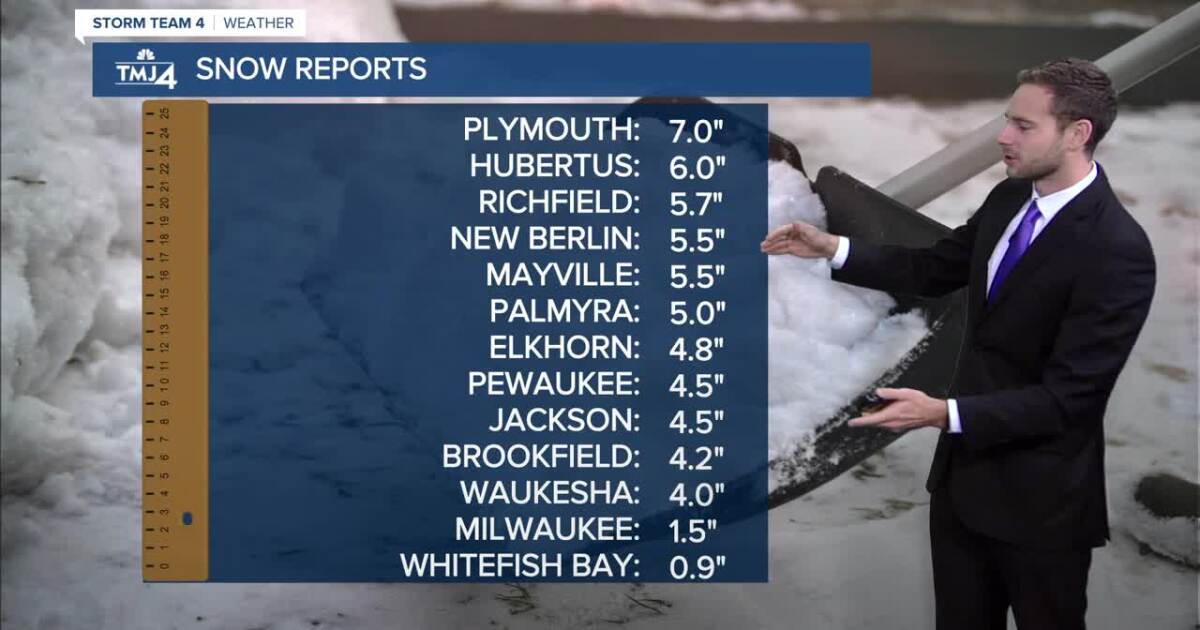
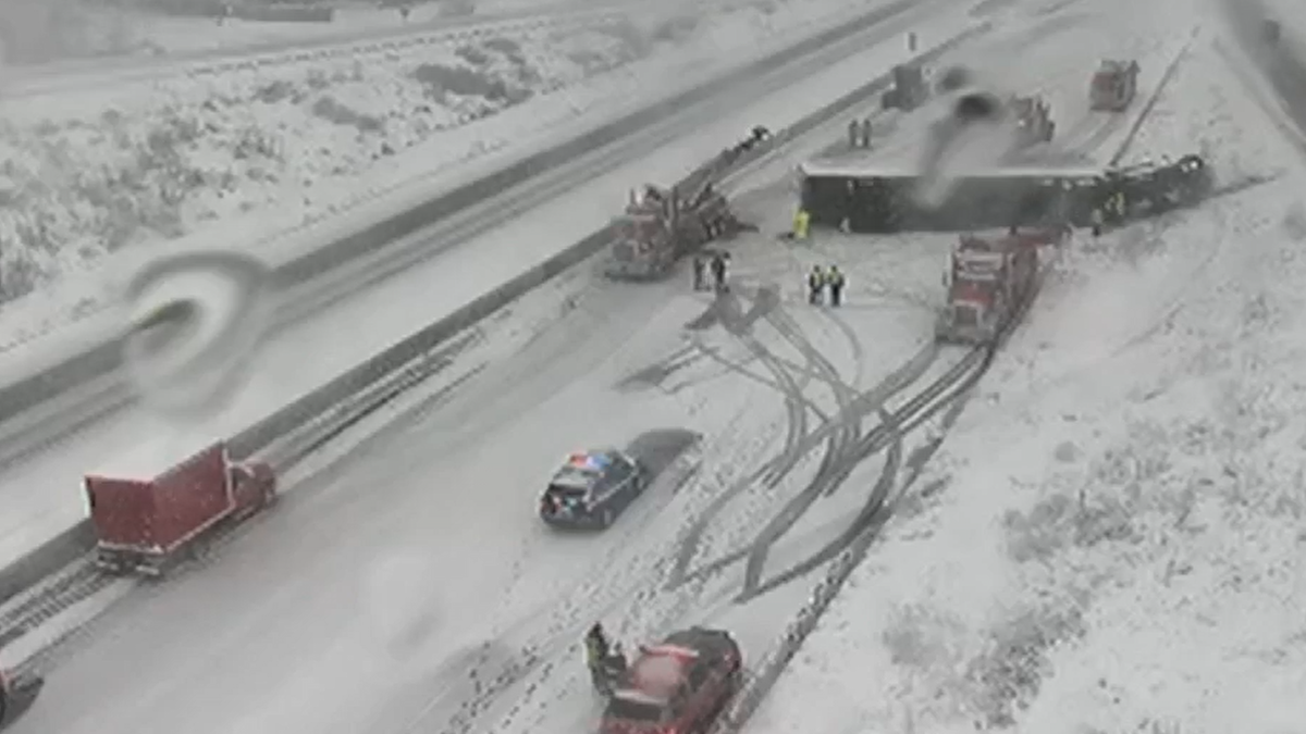
Southeast Wisconsin is experiencing a significant winter storm with considerable snow accumulation and strong winds, leading to challenging conditions for the evening commute and potential power outages. Snowfall totals as of 4 p.m. include 6 inches in West Bend and 4 inches in Plymouth and Greenbush. The heavy, wet snow is impacting road conditions, and additional accumulation is expected overnight. Another clipper system is anticipated to bring more snow on Thursday, with the potential for a larger system in the following week.
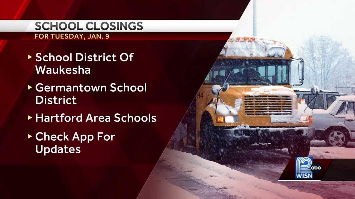
A winter storm advisory is in effect for southeast Wisconsin, with snow expected to start after midnight on Tuesday morning and a winter storm warning in place from 6 a.m. Tuesday through 3 a.m. Wednesday. The Milwaukee area could see between 5 and 7 inches of snow, making it the most significant snowfall since October. Over 280 active closings or delays, including several school districts, have been reported as residents prepare for the incoming snowstorm.
Rain and snow are expected in southeast Wisconsin on Saturday night as a second system moves through the area. Surface and ground temperatures will determine whether areas see rain or snow, with warmer temperatures near the lake leading to rain and colder temperatures inland resulting in snow accumulation. Snowfall amounts could range from 0.5 to 1.5 inches. Another clipper system from Canada is expected to bring wintry precipitation on Monday night into Tuesday morning.
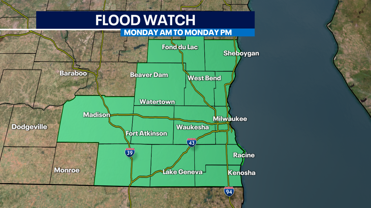
A flood watch has been issued for southeastern Wisconsin due to the forecasted heavy rain, with one to three inches expected and the possibility of even higher amounts. The dry ground will cause runoff, leading to potential flooding in poor drainage, urban, and low-lying areas. The storm system, tracking directly over the region, will bring rain throughout Monday and into the night, with embedded thunderstorms possible. This storm is different from previous ones as it will pivot around an area of low pressure, bringing rain in from the northeast.
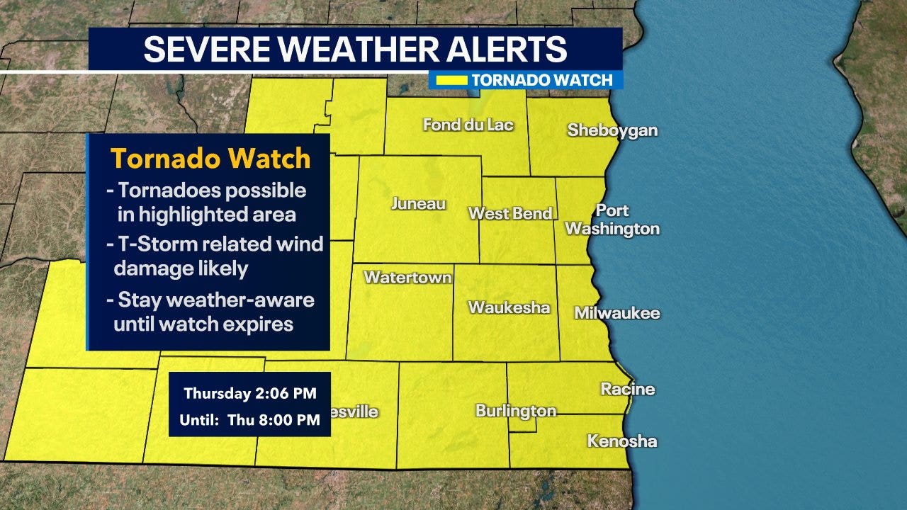
The National Weather Service has issued a tornado watch for southeast Wisconsin until 8 p.m. on Thursday, April 20, with a possibility of a few tornadoes, scattered hail up to two inches in size, and wind gusts up to 75 mph. Strong to severe storms are expected late in the afternoon and evening, with tornado-warned storms already seen on the Mississippi River. FOX6Now.com offers a variety of weather tools to help navigate the stormy season, including maps and radars, school and business closings, and social media updates from the FOX6 Weather Team.
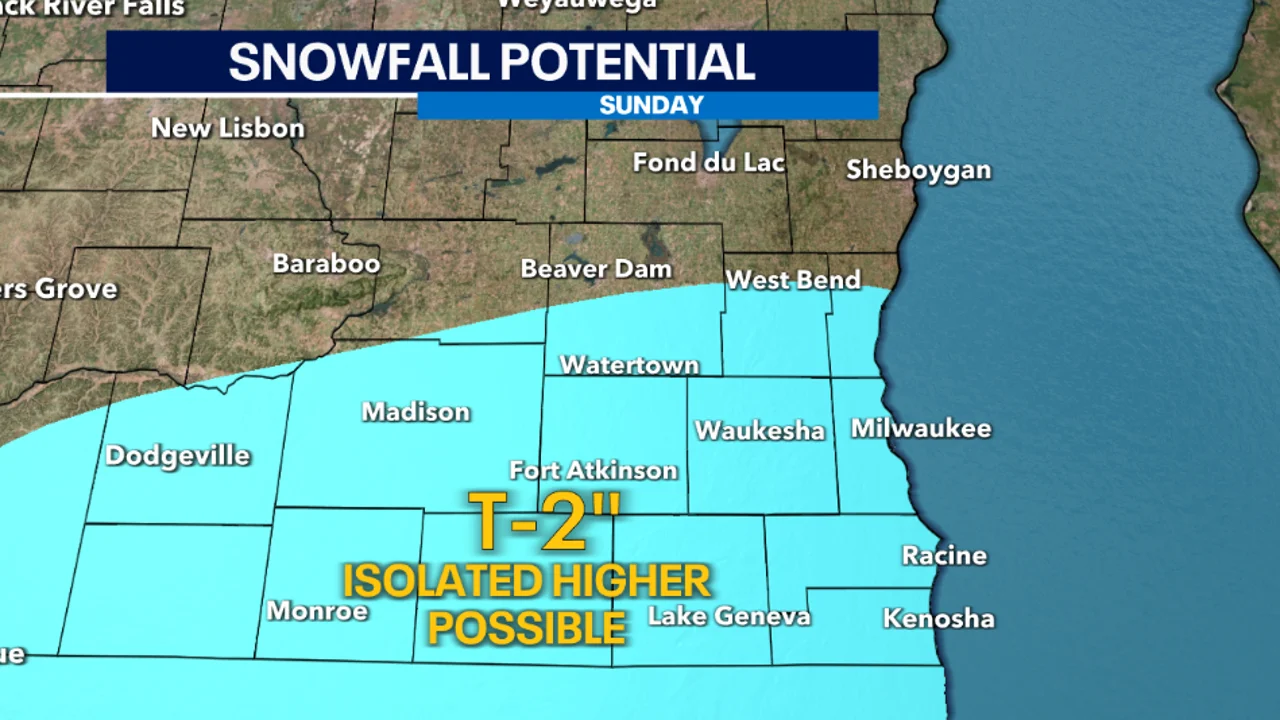
Southeast Wisconsin may see more snow on Sunday, March 26th, with the first round of potential snow/rain mix due to temperatures above freezing. The second round of snow is more likely Sunday night, with higher chances of minor snow accumulations due to temperatures dropping near freezing. Areas further north near Fond du Lac and Sheboygan have lower chances of seeing accumulating snowfall. By Monday morning, all of this will be cleared up for an easier morning commute.
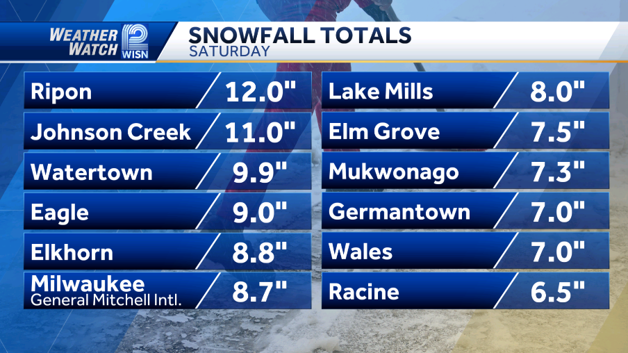
Southeast Wisconsin experienced heavy snowfall causing travel disruptions and power outages. Milwaukee County Sheriff's Office responded to 23 weather-related incidents on freeways. We Energies reported over 1,000 outages before noon Saturday. The Milwaukee Marathon was canceled due to current weather conditions.