Tag

Snow Forecast

All articles tagged with #snow forecast

Hampton Roads Braces for Weekend Snowstorm and High Winds
weather1 month ago

Hampton Roads Braces for Weekend Snowstorm and High Winds

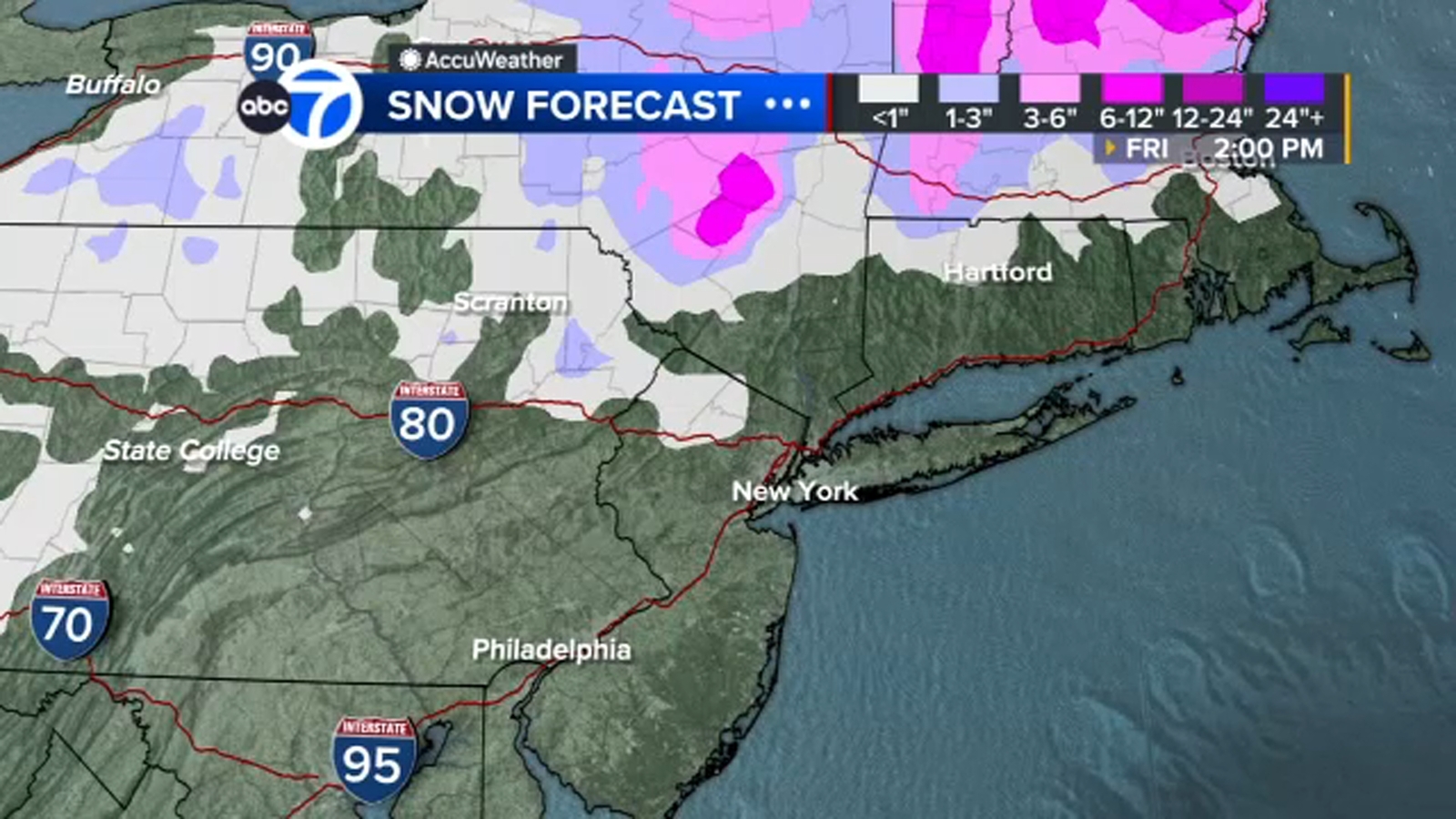
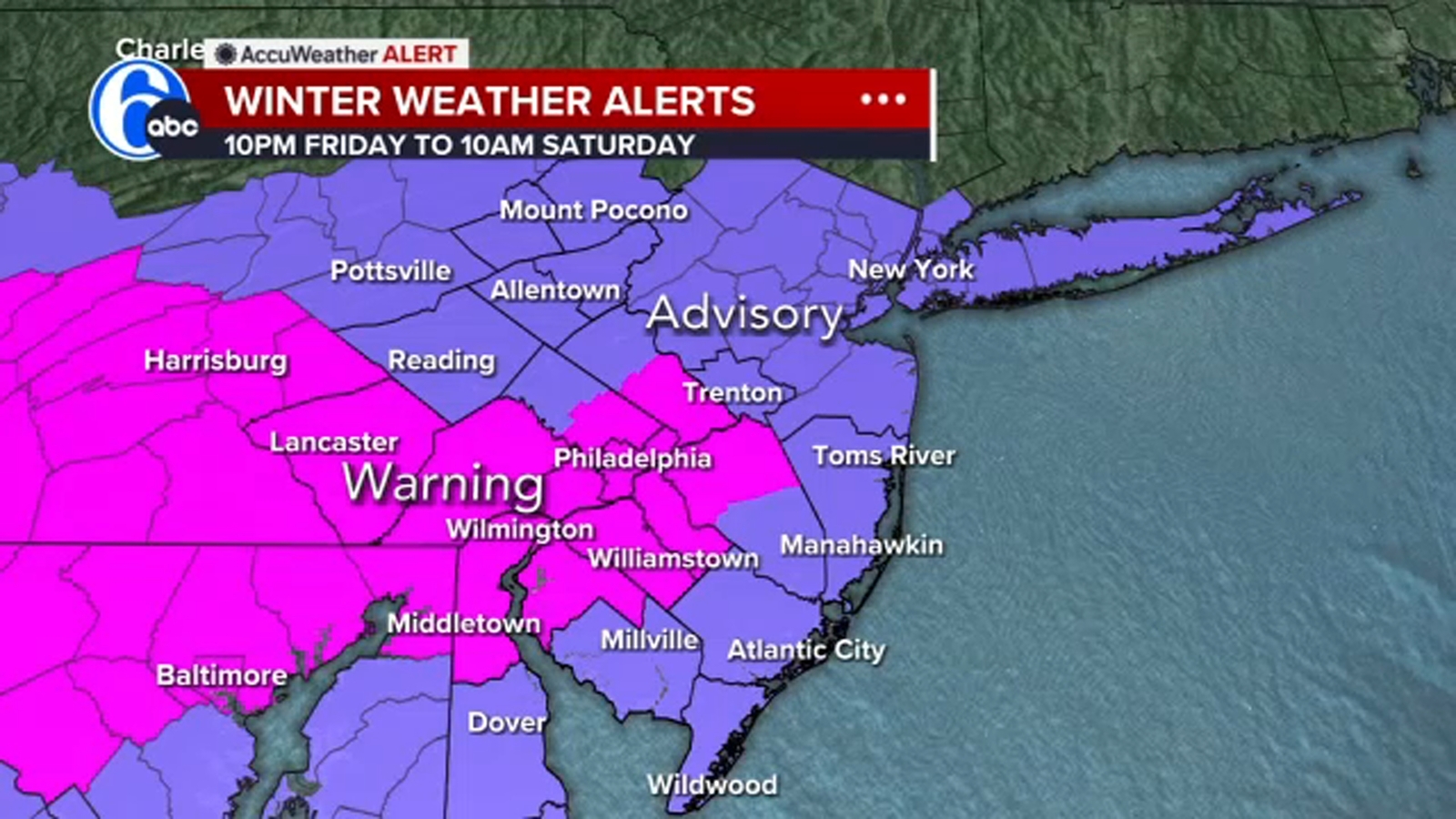
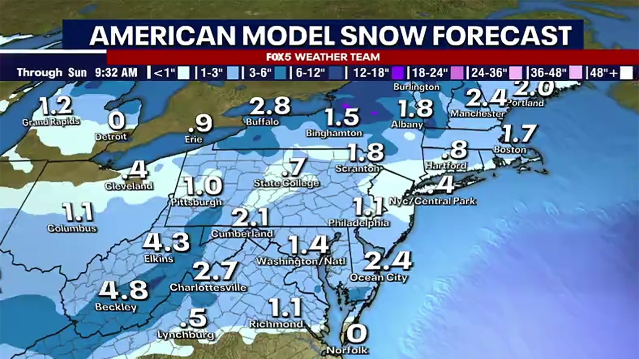
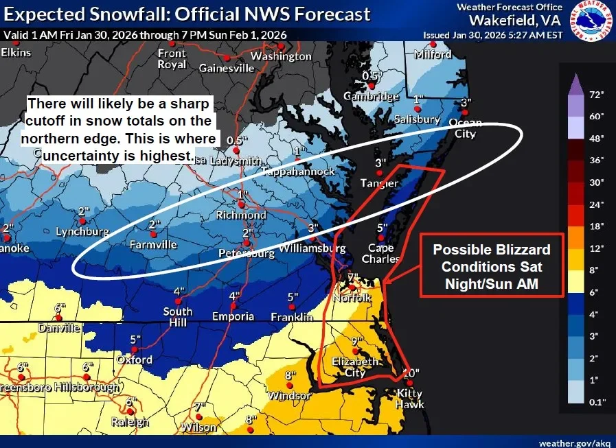
A winter storm warning covers most of Hampton Roads from Saturday morning to Sunday evening, with expected snowfall of 7–12 inches regionwide (coastal areas may see more), strong winds up to 58–60 mph, and potential blizzard conditions along with coastal tidal flooding; wind chills near zero and travel disruptions or power outages are likely, so residents should prepare.

East Coast Faces Possible Bomb Cyclone This Weekend: Three Snow Scenarios
weather1 month ago

East Coast Faces Possible Bomb Cyclone This Weekend: Three Snow Scenarios

Forecasters expect a powerful winter storm to form off the Carolinas this weekend and intensify into a bomb cyclone, though its exact track remains uncertain. Models outline three main scenarios: a coastal storm that spares major Northeast cities, a near-coast path bringing heavy snow from the Mid-Atlantic to New England, or a farther-out system that stays offshore with minimal impacts. Small track shifts (around 100–200 miles) could mean the difference between significant snow for the I-95 corridor and a cold, windy weekend elsewhere, so residents should monitor forecasts for potential blizzard winds, coastal impacts, and beach erosion.

Northeast Prepares for Major Snowfall as Winter Storm Approaches
weather3 months ago

Northeast Prepares for Major Snowfall as Winter Storm Approaches

A coastal storm is expected to bring 2 to 7 inches of snow to northwestern New Jersey, especially Sussex County, on Tuesday, with the possibility of heavy rain elsewhere in the state. Travel disruptions are anticipated, and the forecast remains uncertain due to storm track variations. Cold temperatures will follow the storm, with potential for additional winter weather next weekend.

Severe Weather Alerts: Wind, Snow, and Frigid Temps Expected Thursday
weather1 year ago

Severe Weather Alerts: Wind, Snow, and Frigid Temps Expected Thursday

A wind advisory and blizzard warning have been issued for December 4, 2024, as a clipper system moves through Canada, bringing strong winds and snow to the Great Lakes region. The cold front will reach metro areas before sunrise on Thursday, causing temperatures to drop rapidly and wind chills to fall into the teens and 20s. Snowfall is expected to be less than 1 inch, with potential whiteout conditions in the mountains due to strong winds. The weekend will be cold and dry, with rain expected early next week.

Winter Storms Threaten Thanksgiving Travel Across US
weather1 year ago

Winter Storms Threaten Thanksgiving Travel Across US

A slow-moving storm is expected to bring rain and potentially snow to upstate New York later this week, with areas south of Rochester, such as the Bristol Hills and Southern Tier, possibly seeing their first measurable snow. While Rochester may experience some snowflakes, significant accumulation is not anticipated. The forecast remains uncertain as the storm develops, with the Adirondacks potentially receiving a few inches of snow. The region has experienced a mild November, but temperatures are expected to return to normal levels.

"Power Outage Potential: Long-lasting Winter Storm Forecast for Upstate NY and Vermont This Week"
weather1 year ago

"Power Outage Potential: Long-lasting Winter Storm Forecast for Upstate NY and Vermont This Week"

Upstate New York and parts of the Tri-State area are bracing for a spring storm bringing heavy snow, rain, and high wind gusts, with the Adirondacks and Catskills expecting up to two feet of snow. While areas like New York City will be spared from snow, they will experience intense rainfall and potential flooding between Tuesday and Thursday, with wind gusts posing a threat as well. Showers are expected to linger through the weekend.

"Northeast Winter Storm: Snow Forecast for Philadelphia, PA and Surrounding Areas"
weather2 years ago

"Northeast Winter Storm: Snow Forecast for Philadelphia, PA and Surrounding Areas"

A winter storm warning has been issued for the Philadelphia region, with 2-6 inches of snow expected across different areas. Authorities and crews are preparing for the storm, with PennDOT fully stocked with salt and trucks, and the city of Philadelphia deploying over 450 pieces of equipment and 35 tons of salt. Safety measures for winter driving and Code Blue for homeless individuals have been activated, and residents are advised to stay updated on real-time traffic and weather conditions.

"Winter Storm Lorraine Brings Heavy Snow and School Closings to Northeastern US"
weather2 years ago

"Winter Storm Lorraine Brings Heavy Snow and School Closings to Northeastern US"

Another winter storm is expected to bring several inches of snow to parts of NYC, New York, and New Jersey from Friday night into Saturday morning, with up to 3 inches possible in central and southern New Jersey and 1 to 2 inches in other areas including northern New Jersey and New York City. The mid-winter forecast suggests the potential for several more inches of snow in the NYC area, with February likely to bring the perfect conditions for winter storm development due to strong El Niño conditions.

"Michigan Storm System: Snowfall Breakdown by Region"
weather2 years ago

"Michigan Storm System: Snowfall Breakdown by Region"

A fast-moving storm system is expected to bring a mix of rain and snow to southern Michigan, with the rain/snow line running from Grand Rapids to Flint. Areas south of this line, including Grand Rapids, Lansing, Flint, Kalamazoo, Jackson, Ann Arbor, and Detroit, are likely to see little to no snow accumulation as temperatures rise above freezing, causing the snow to melt. Meanwhile, areas north of the line could experience a few hours of accumulating snow, with the potential for 1-3 inches in Grand Rapids and Flint.

"Unexpected Snowfall Shifts Forecast for Northeastern US"
weather2 years ago

"Unexpected Snowfall Shifts Forecast for Northeastern US"

A major winter storm missed New Hampshire after a significant shift in the storm's track just 24-36 hours before its arrival, leading to only light snow in far southern parts of the state. Meteorologists rely on computer models to make forecasts, and the sudden change was due to a southward shift in the storm's track shown by multiple model runs. Despite modern technology improving forecast accuracy, meteorology remains an imperfect science, and the team aims to continue providing the most accurate forecasts for New Hampshire.

"February Winter Storm Brings Heavy Snow to Pennsylvania Communities"
weather2 years ago

"February Winter Storm Brings Heavy Snow to Pennsylvania Communities"

A winter storm is expected to bring snow and rain to the Delaware Valley, with Philadelphia likely to see 2-4 inches of snow after rain changes over later in the morning. The Poconos could get 6-10 inches, while areas under the Winter Storm Warning may see 4-8 inches. The storm will impact the morning commute, with travel advisories in place and school closures reported. Cooler and drier weather is expected for Valentine's Day, with temperatures climbing back above freezing by Wednesday afternoon.

"Nor'easter Forecast: Snowfall Predictions for Northeastern Cities"
weather2 years ago

"Nor'easter Forecast: Snowfall Predictions for Northeastern Cities"

The Northeast and New England are bracing for a potential nor'easter that could bring heavy snow, gusty winds, and moderate coastal flooding. New York City could see at least half a foot of snow, while Boston expects 4 to 8 inches and Philadelphia anticipates a wide range of snow totals. The National Weather Service issued winter storm warnings and forecasts snowfall rates of 1 to 2 inches per hour in various areas, with concerns about strong winds and coastal flooding.

"First Alert: Winter Weather Advisory for Accumulating Snow Tonight"
weather2 years ago

"First Alert: Winter Weather Advisory for Accumulating Snow Tonight"

WKYT declares a First Alert Weather Day as they monitor a complex snow forecast, with rain expected to transition into thunder and then heavy snow as low pressure moves through the region. The band of heavy snow is predicted to set up near Lexington into southern and southeastern Kentucky, potentially bringing a few inches of snow. Despite the snow, temperatures are expected to rise in the coming days, reaching the 40s and even 50s, with the possibility of another winter blast over the weekend.