Tag

First Alert Weather Day

All articles tagged with #first alert weather day

"Intense Winter Weather: Snowfall and Rain Expected Across Western States"
weather2 years ago

"Intense Winter Weather: Snowfall and Rain Expected Across Western States"

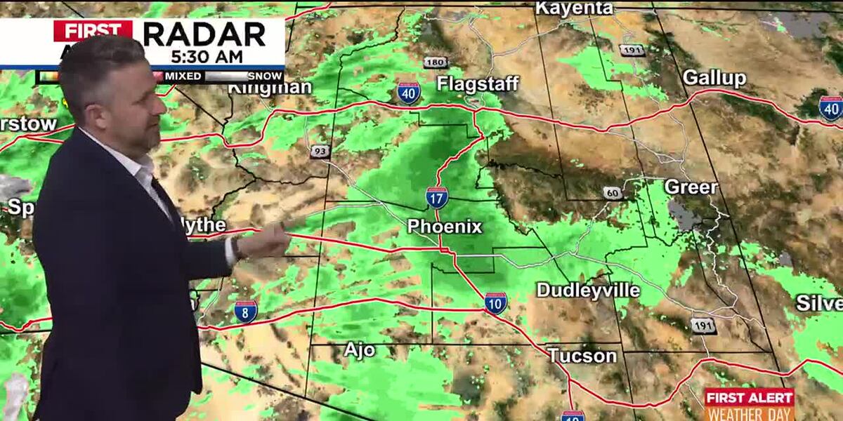
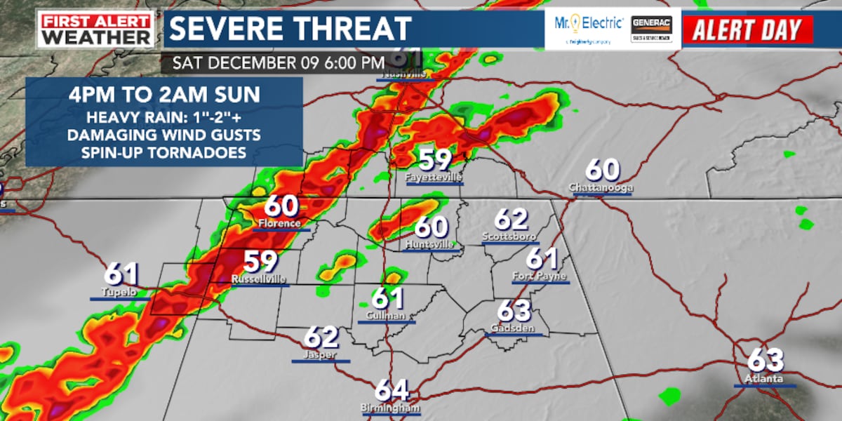
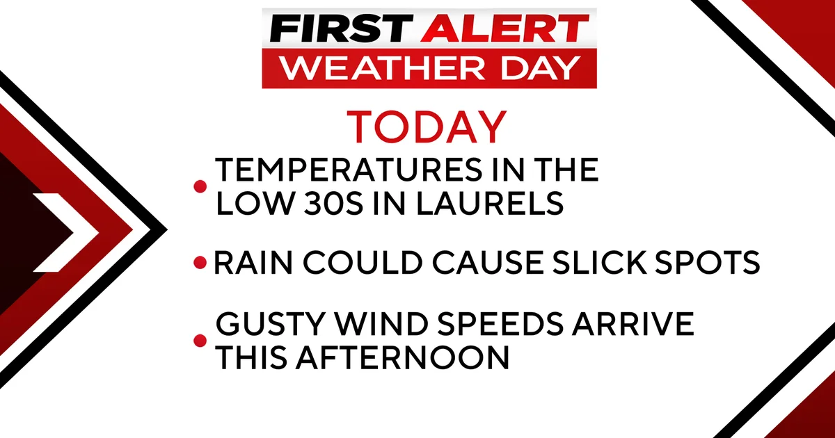
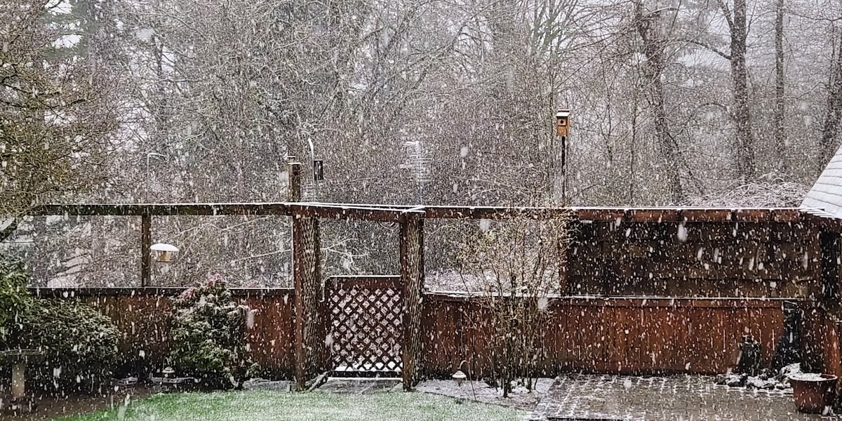
A strong cold front is causing the snow level to drop dramatically in western Washington and western Oregon, with the potential for lowland snow and heavy precipitation. Locations near sea level and east of I-5 could see a wintry mix, while areas above 500 feet may accumulate a quick inch or two of snow. Showers, graupel, small hail, and isolated thunderstorms are also expected. Snow will continue to pile up in the Cascades and Coast Range, prompting a First Alert Weather Day for both mountain ranges. Showery weather will persist through the weekend, with the potential for minor snow accumulation in the lowlands.

"First Alert: Winter Weather Advisory for Accumulating Snow Tonight"
weather2 years ago

"First Alert: Winter Weather Advisory for Accumulating Snow Tonight"

WKYT declares a First Alert Weather Day as they monitor a complex snow forecast, with rain expected to transition into thunder and then heavy snow as low pressure moves through the region. The band of heavy snow is predicted to set up near Lexington into southern and southeastern Kentucky, potentially bringing a few inches of snow. Despite the snow, temperatures are expected to rise in the coming days, reaching the 40s and even 50s, with the possibility of another winter blast over the weekend.

"Severe Winter Weather Returns to Pittsburgh Area, Impacting Tuesday Commute"
weather2 years ago

"Severe Winter Weather Returns to Pittsburgh Area, Impacting Tuesday Commute"

Parts of the Pittsburgh area, including Clarion and Jefferson Counties, are under a winter storm watch for the potential of heavy, wet snow as an approaching storm system brings rain later Monday evening. The storm track is uncertain, with models disagreeing on where the low will track and the rain/snow changeover spot. Tuesday morning has been declared a First Alert Weather Day with a wet, possibly white, and wintry mix for the commute, and chillier air will bring lows back below freezing through the week, with rain and snow showers possible from Wednesday through Thursday.

Weekend Winter Storm: Snow and Severe Weather Expected in Texas
weather2 years ago

Weekend Winter Storm: Snow and Severe Weather Expected in Texas

A winter storm is expected to hit the South Plains late Saturday, bringing cooler temperatures and showers that will gradually change to snow by mid-day Sunday. Snowfall amounts could reach four to eight inches in northern counties, with potential travel issues in the area. Lows are expected to dip to the low 20s on Monday morning before warming up to near 50.

"Winter Storm Paralyzes Arizona with Heavy Rain, Snow, and Highway Closures"
weather2 years ago

"Winter Storm Paralyzes Arizona with Heavy Rain, Snow, and Highway Closures"

Arizona is experiencing a major winter storm with heavy rain and snow, prompting the declaration of First Alert Weather Days for Wednesday and Thursday. The Flood Warning for the deserts has been cancelled, but there's a 40 percent chance of showers and thunderstorms in the Valley with potential for heavy rain, lightning, and small hail. The high country is facing heavy snow and blowing snow, with Flagstaff expecting up to 16 inches of snow. A second storm is expected to bring widespread rain on Thursday, while a third storm will bring more high country snow on Friday and Saturday.

"Arizona Braces for Major Winter Storm and Wind Advisory"
weather2 years ago

"Arizona Braces for Major Winter Storm and Wind Advisory"

A major winter storm is moving into Arizona, bringing desert rain, mountain snow, strong winds, and cooler temperatures. Western Arizona is under a Flood Watch, while the Valley metro area will also experience rain and potential thunderstorms, with up to 3/4 inch of rain expected. The high country will see heavy snow and blowing snow, making travel difficult and dangerous. Additional storms are expected to bring more rain and snow throughout the week, with Sunday currently forecasted to be dry.

"Tuesday's Treacherous Weather: Freezing Rain and Bitter Cold"
weather2 years ago

"Tuesday's Treacherous Weather: Freezing Rain and Bitter Cold"

A First Alert Weather Day has been issued for the Portland metro and south into the valleys, with freezing rain expected to arrive late Tuesday afternoon and continue into early Wednesday morning. Milder air will bring thawing on Wednesday, with rainy conditions expected on Thursday and mostly dry weather on Friday. The Gorge is likely to see the worst of the ice storm, with travel advisories in place for both the Portland metro and the Gorge due to slick conditions.

"Midwest Winter Storm Update: Snow Clears, Wind Picks Up, Schools Close"
weather2 years ago

"Midwest Winter Storm Update: Snow Clears, Wind Picks Up, Schools Close"

Tuesday in Omaha, Nebraska is a 6 First Alert Weather Day as snow exits by 10am, but gusty north winds and falling temperatures will cause blowing snow and bitter cold air. Additional light snow is possible until 10am, with north wind gusts up to 45 mph expected in the morning. Another round of light snow is possible on Wednesday afternoon, with a potential for more snow on Thursday night.

Sunday's Weather Forecast: Rainstorms Turning to Snow with Flood Watch
weather2 years ago

Sunday's Weather Forecast: Rainstorms Turning to Snow with Flood Watch

A First Alert Weather Day has been issued for Sunday as rain transitions to snow in Pittsburgh and surrounding areas. Slick spots are possible due to colder temperatures, and scattered lake effect snow is expected on Monday. While big accumulations of snow are not anticipated, Garrett County, Maryland, is under a winter weather advisory with potentially hazardous travel conditions. Lake effect snow showers will continue on Monday, with higher accumulations in the ridges. Skies will begin clearing on Tuesday, and temperatures will remain near average until later in the week.

"Stay Safe: Guide to Severe Storms Moving in Tonight"
weather2 years ago

"Stay Safe: Guide to Severe Storms Moving in Tonight"

A First Alert Weather Day has been issued for Middle Tennessee due to strong to severe storms, including tornado watches and warnings. Residents are advised to stay safe by monitoring power outages, reporting damage or requesting assistance at emergency management offices, checking flight statuses at Nashville International Airport, monitoring road conditions, and downloading the WSMV 4 First Alert Weather app for alerts and custom videos about the weather.

Severe Storms Expected: Another Rainy Weekend Ahead
weather2 years ago

Severe Storms Expected: Another Rainy Weekend Ahead

A First Alert Weather Day has been issued for the threat of strong to severe storms developing this afternoon through early Sunday morning in Alabama. The main concerns include damaging wind gusts, locally heavy rainfall, flash flooding, and spin-up tornadoes. Residents are advised to have their severe weather plan in place and stay updated on warnings. Lingering light rainfall is expected on Sunday morning before colder and drier air moves in, bringing gradually clearing skies and breezy winds. Monday morning may bring patchy dense fog and freezing fog, with isolated icy spots possible. Monday afternoon will see sunshine and temperatures in the upper 40s.

Winter Weather Alert: Snow Showers Today, Widespread Snow Expected Monday
weather2 years ago

Winter Weather Alert: Snow Showers Today, Widespread Snow Expected Monday

A weak wave of low pressure will bring light snow showers to northern Maine today, with accumulation of up to 3 inches possible. Cloudy skies and patchy fog will persist throughout the day, with temperatures reaching the low to mid 30s north and low to mid 40s Downeast. On Sunday, a low pressure system will develop, bringing a mix of snow and rain to the state. Accumulating snowfall is expected, with the greatest amounts in the central and western mountains. A First Alert Weather Day has been issued for inland locations on Monday. Lingering snow showers are possible through Tuesday morning, followed by colder temperatures for the rest of the week.

Wet and Windy Weather Forecast for Holiday Travel
weather2 years ago

Wet and Windy Weather Forecast for Holiday Travel

Rain and windy conditions are expected throughout the day, with rain totals of around a half inch to three-quarters of an inch. The Laurel Highlands may experience a wintry mix of mostly rain, with temperatures in the mid to low 30s. Slick spots are possible in the Laurels, and a Winter Weather Advisory is in effect until noon. A wind advisory will begin at noon for the Laurels and surrounding areas, with wind gusts potentially exceeding 50mph. Thanksgiving Day is expected to be dry and seasonal, with highs in the upper 40s. The next chance for rain comes on Sunday evening into Monday morning.