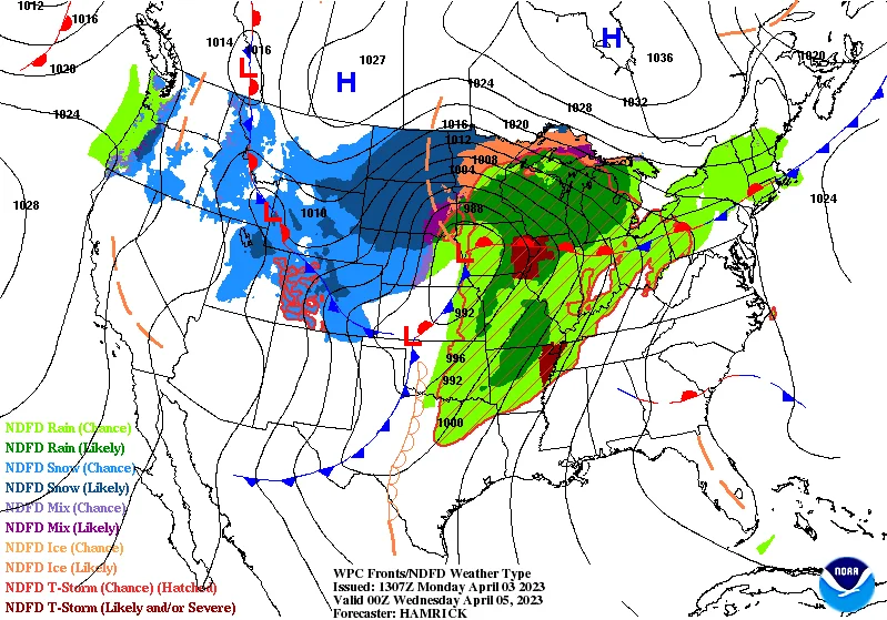
A spring storm brought hail, snow, and cold temperatures to Southern California, with reports of hail falling in various neighborhoods and fresh snow in the mountains. The storm is expected to move through the region quickly, with a winter storm warning in effect for the San Gabriel Mountains and the 14 Freeway corridor, and a winter weather advisory for the Antelope Valley foothills and the 5 Freeway corridor.
A major spring storm brought heavy snow, rain, and high winds to the Northeast, leaving hundreds of thousands without power and contributing to at least two deaths. Cleanup efforts have begun as snow showers linger, with utility crews working to restore power and assess damage. The storm, the biggest April nor'easter since 2020, caused treacherous travel conditions and potential avalanches in some areas, while also leading to flooding in West Virginia. Despite the dangers, some New Englanders are taking the weather in stride and enjoying the snow.
A spring storm is expected to bring moderate to heavy rain, strong winds, and snow to central New York, with rainfall totals of 1-2 inches and wind gusts reaching 60+mph. Winter weather advisories are in effect for eastern counties due to moderate snowfall and gusty winds, with lower elevations likely to see 1-3 inches of snow. Lingering lake effect snow flurries are expected on Friday and Saturday, followed by dry and warm conditions for the weekend.
Upstate New York and parts of the Tri-State area are bracing for a spring storm bringing heavy snow, rain, and high wind gusts, with the Adirondacks and Catskills expecting up to two feet of snow. While areas like New York City will be spared from snow, they will experience intense rainfall and potential flooding between Tuesday and Thursday, with wind gusts posing a threat as well. Showers are expected to linger through the weekend.
A powerful spring storm has brought tornadoes to the Plains and the South, with tornado warnings issued for parts of Texas, Louisiana, and Arkansas. Severe weather alerts are in place for nine million Americans across the Lower Mississippi Valley, and blizzard conditions are affecting the central and Midwest regions. The storm is expected to continue through Tuesday, with concerns of damaging winds, large hail, and possible strong tornadoes as it reaches East Texas, Louisiana, and Mississippi.
The Northeast U.S. is experiencing a wintry mix of wind, rain, sleet, and heavy snow on the first weekend of spring, with over a foot of snow expected in some areas and potential flooding in southern regions and along the coast. Maine and New Hampshire are facing treacherous travel conditions, while Connecticut, New York City, Rhode Island, and Massachusetts are expecting rain and freezing precipitation. Flood advisories have been issued for various areas, and the storm is set to clear out by Sunday morning.
A springtime snowstorm is impacting Maine, bringing a Winter Storm Warning with snow, sleet, and rain forecasted. The storm is expected to bring heavy, freezing rain in the evening, potentially leading to flooding on the coast, while snow continues in the mountains. The mountains are expected to receive 10 to 14 inches of snow, with lower snow totals closer to the coast. The storm system is expected to wrap up overnight Saturday into Sunday, with Sunday looking better for Maine Maple Sunday.
Denver is set to experience a shift in weather as a spring storm approaches, bringing wet conditions and the possibility of snow to the area by the end of the weekend. While the impact on the metro area is expected to be minimal, some areas may see spotty snow and rain, with the potential for 2-5 inches of snow along the Palmer Divide and more in the mountains. The Pinpoint Weather team will continue to track the storm and provide updates as it develops.
A major early-spring storm is set to bring heavy snow, ice, and severe storms across the US this weekend into next week, affecting a wide area from the West to the Midwest and South. The storm will bring heavy snow to mountain ranges, moderate rain in major cities, and a severe storm threat with damaging winds, large hail, and potential tornadoes. Cold air from Canada will bring temperatures 10-30 degrees below average, with the chill expected to last through the end of the month across the western half of the country.
A spring storm is expected to bring several inches of snow to Michigan, including Metro Detroit, on Friday, impacting the morning and evening commutes. Accumulations of 1-2 inches are likely in the Metro area, with greater amounts possible north of M-59. West Michigan may see snow totals exceeding 4 inches near and north of I-96, while Northern Lower Michigan and the Upper Peninsula could also experience hazardous driving conditions due to snow.
A spring storm is expected to hit Colorado, bringing feet of snow to the mountains and foothills and inches of rain to the Fort Collins and Interstate 25 corridor. A winter storm watch has been issued for the northern mountains and foothills, with hazardous travel conditions expected. Snowfall rates of 2 inches per hour are possible during the heaviest hours, and some areas could see a slushy Wednesday morning commute. The I-25 corridor is expected to receive 0.5 to 2 inches of rain with some locally heavier amounts possible.
Colorado is expected to experience heavy rain and snow due to a spring storm that will last from Tuesday to Wednesday. Temperatures will drop by nearly 20 degrees, with the biggest impact of the storm expected on Wednesday. Snow totals are difficult to forecast, but the Pinpoint Weather team expects 0-5 inches of accumulation in Metro Denver, 5-10 inches in Foothills/Palmer Divide, and 4-24 inches in the Mountains. Stay updated with the latest forecast using the free Pinpoint Weather app.
A powerful spring storm is expected to bring snow and rain to Minnesota on Tuesday and Wednesday, with significant snowfall for much of northern and west central Minnesota. Northwest Minnesota could see over a foot of snow in many areas along with potential blizzard conditions. In addition to precipitation, high wind gusts are also expected to develop late Tuesday into Wednesday. While a warming trend is expected for the upcoming weekend, it's still early April and forecasting specifics past 5 days is treacherous.
A spring storm is expected to hit Maine this weekend, bringing some snow to the region. The forecast predicts that the storm will bring a mix of rain and snow to coastal areas, while inland areas could see up to 6 inches of snow accumulation.