Tag

Satellite Imaging

All articles tagged with #satellite imaging

science24 days ago

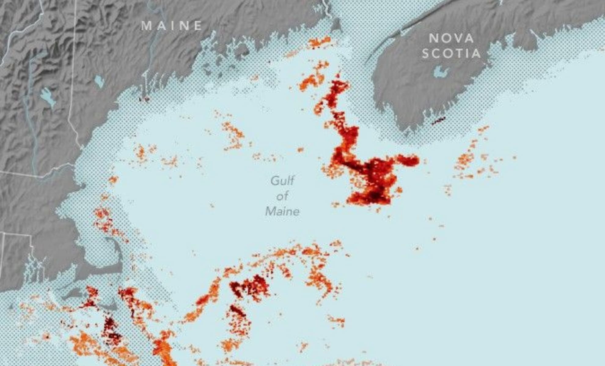
NASA Scientists Discover Tiny Red Creature Supporting Whale Life

NASA's Aqua satellite has successfully detected dense patches of the tiny red plankton Calanus finmarchicus off the New England coast, a crucial food source for the endangered North Atlantic right whale, using innovative remote sensing techniques. This breakthrough allows for better monitoring of marine ecosystems and could help protect whales by predicting their movements and reducing human-related threats.

science24 days ago

NASA Scientists Discover Tiny Red Creature Vital for Whale Survival

NASA's Aqua satellite has successfully detected dense patches of the tiny red plankton Calanus finmarchicus off the New England coast, a crucial food source for the endangered North Atlantic right whale, using innovative remote sensing techniques. This breakthrough allows for better monitoring of marine ecosystems and could help protect whales by predicting their movements and reducing human-related threats.

space-technology1 year ago

"Turion Space Nearing Launch of First Satellite's Initial SSA Service"

Turion Space's debut satellite, Droid.001, is set to begin imaging objects in space by May after a year of commissioning in low Earth orbit. The California-based startup aims to provide space situational awareness (SSA) services and plans to sell imagery to the U.S. Department of Defense and satellite operators. The company also intends to launch an "enhanced mobility vehicle" in 2026 for debris removal and has received contracts from NASA, Space Force, and the Air Force. Turion is preparing to launch another demo spacecraft, Droid.002, with higher resolution imaging capabilities, and aims to produce 10 spacecraft by 2026 for sale to other operators.

science-and-technology2 years ago

NASA's New TROPOMI Tool Revolutionizes Algal Bloom Tracking

NASA's TROPOMI instrument, designed to measure air pollution, has demonstrated its ability to detect harmful algal blooms by capturing the faint red glow emitted by the algae responsible for these blooms. TROPOMI's advanced imaging capabilities allow it to penetrate thin cloud cover and gather twice as much fluorescence information as previous methods relying on ocean color. This technology could help federal agencies and local communities better forecast and manage harmful outbreaks, protecting public health and coastal ecosystems. Additionally, upcoming satellite missions like NASA's PACE will further enhance our ability to monitor algal blooms and other factors affecting marine ecosystems.

space2 years ago

China's Tiangong Space Station Captured in Stunning Satellite Video

Australian company HEO Robotics has released satellite images showcasing the construction of China's Tiangong space station. The images, captured over an 18-month period, reveal the step-by-step assembly of the three-module space station, verified by photos taken from other satellites. HEO Robotics specializes in non-Earth imaging and offers services to visually monitor space objects. China aims to keep the Tiangong space station occupied for at least a decade and potentially utilize it for commercial purposes.

science-and-technology2 years ago

Satellite Imaging Pioneer Virginia Norwood Passes Away at 96.

Virginia Norwood, an aerospace pioneer and physicist, has died at the age of 96. She invented the multispectral scanner system (M.S.S.) that made it possible to map and study the earth from space, which has been used for more than 50 years by the United States Geological Survey's Landsat satellite program. The program has provided powerful visual evidence of climate change, deforestation, and other shifts affecting the planet's well-being. Ms. Norwood oversaw the development of Landsat 2, 3, 4, and 5, and her original concept has been the basis for each generation satellite.