Researchers at Brookhaven National Laboratory have developed a high-resolution lidar that acts like a microscope for clouds, revealing new insights into cloud top structures and dynamics, which could improve climate models and weather predictions.
Aguada Fénix, the oldest and largest Maya site built around 3050 years ago in Mexico, was discovered using LiDAR technology. Its design reflects a cosmological model, with ritual significance tied to directions and calendar dates, and was likely constructed by community effort without hierarchical leadership, challenging previous assumptions about ancient monumental construction.
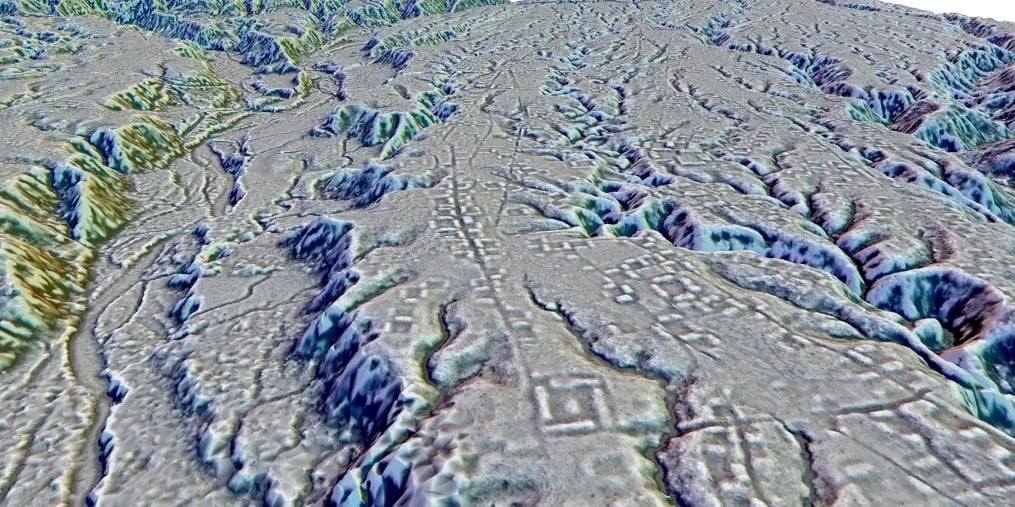
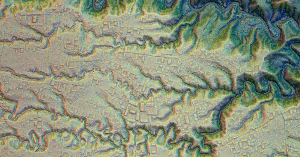
Using Lidar technology, archaeologists have discovered a network of 15 ancient settlements in the Amazon rainforest's Upano Valley in eastern Ecuador, challenging the belief that Indigenous people in the region were primarily nomadic. The settlements, sprawled over 115 sq miles, feature rectangular earthen platforms, large roads, and evidence of advanced engineering and building skills. The findings suggest a stratified society with urbanistic systems, prompting further excavation to uncover more about the ancient people's beliefs and way of life.
Using lidar technology and decades of research, archaeologists have discovered a cluster of ancient cities in the Amazon's Upano Valley in eastern Ecuador, revealing evidence of dense settlements in the region dating back to around 500 B.C. The findings, published in the journal Science, showcase the use of laser-mapping technology to uncover five major settlements and 10 secondary sites across more than 115 square miles, shedding new light on the ancient history of the Amazon.
A team led by Stéphen Rostain used LiDAR technology to uncover a massive pre-Columbian civilization in the Amazon rainforest, challenging assumptions about the region's history. The discovery of over 6,000 raised earthen platforms covering 115 square miles, along with canals and roads, suggests a complex society of at least 10,000 inhabitants dating back to before 500 A.D. This finding opens up new avenues for archaeological investigation and prompts a reevaluation of historical narratives about the Amazon's ancient civilizations.
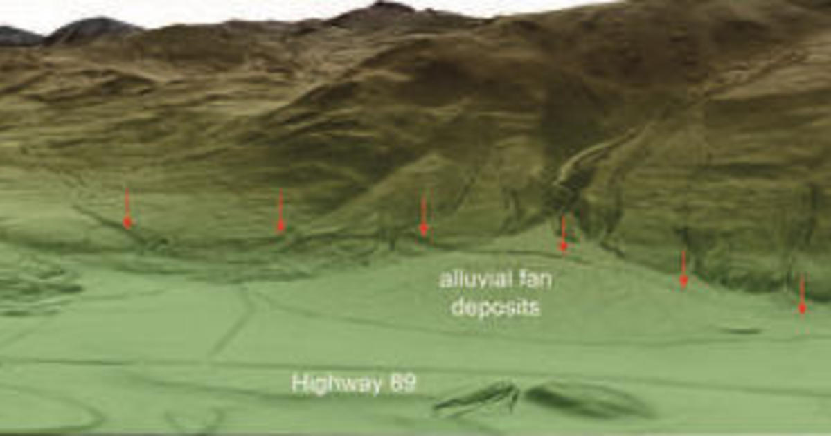
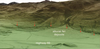
Lidar technology has revealed a network of active faults in the northern region of Yellowstone National Park, posing earthquake threats to nearby communities. Lidar, a remote sensing technique, uses laser sensors to detect concealed features on the ground. The surveys conducted in 2020 uncovered fault scarps and breaks in the ground, indicating past earthquakes of magnitude-6.5 or greater. The data will help geologists analyze the faults and assess future risks. Lidar technology also offers insights into the link between seismic events, geothermal activity, and volcanic activity in Yellowstone.
New data obtained through lidar technology has revealed a network of geological hazards, including prehistoric landslides and large earthquakes, beneath a portion of Yellowstone National Park. The data, which provides a clearer view of the bare ground in the region, is helping scientists understand the present-day risks of living in the surrounding states. The discoveries have allowed for better characterization of known faults and landslides, improving hazard maps and contributing to mitigation efforts. While the chance of a volcanic eruption in Yellowstone is unlikely, the area is still prone to damaging earthquakes and hydrothermal explosions.
New data obtained through lidar technology has revealed a network of geological hazards, including prehistoric landslides and large earthquakes, beneath a portion of Yellowstone National Park. The data, which provides a clearer view of the bare ground in Paradise Valley and the northern entrance to Yellowstone, has helped scientists understand the present-day risks of living in the surrounding states. The discoveries have allowed for improved hazard mapping and characterization of known faults and landslides, contributing to mitigation efforts and seismic hazard assessments. While the chance of a volcanic eruption in Yellowstone is unlikely, the area remains of interest due to the likelihood of damaging earthquakes and hydrothermal explosions.
Archaeologists have used drones and LiDAR technology to uncover previously unknown details about the Battle of the Bulge, the bloodiest battle the United States fought in World War II. The study revealed almost a thousand hidden archaeological features at the battlefield site, including dugouts, foxholes, trenches, bomb craters, and artillery emplacements. The research sheds new light on the battle and could have implications for understanding other World War II battlefields. Additionally, the use of these techniques may help protect battlefield landscapes from deforestation.
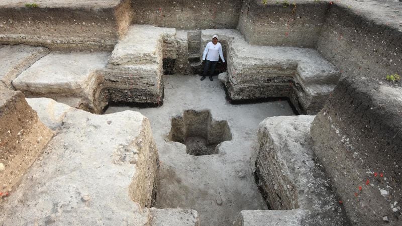
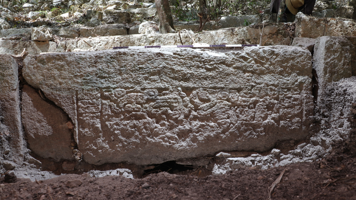
Scientists using lidar technology have discovered a previously unknown and massive Maya city called Ocomtun in Mexico's Yucatan Peninsula. The city, which may have served as a political center, challenges previous assumptions about the Maya civilization's range. Lidar imaging, combined with on-foot verification, revealed monumental structures and puzzling shapes, suggesting Ocomtun's significance. The site contains architectural complexes requiring hundreds of laborers and dates back to the late Classic period, with some objects indicating an even earlier timeline. The discovery raises questions about the Maya's endurance and offers insights into ancient civilizations.
Using airborne LiDAR technology, archaeologists have discovered and mapped over 61,000 ancient structures, including houses, palaces, ceremonial centers, and pyramids, hidden beneath Guatemala's Petén rainforest. The findings indicate that the ancient Maya civilization transformed their landscape on a grand scale, supporting a population of 7 to 11 million people during the Late Classic period. The discovery also reveals extensive causeways and interconnected urban centers, shedding new light on Maya civilization and prompting further research and exploration.
A previously unknown ancient Maya city, named Ocomtun, has been discovered in the jungles of southern Mexico using aerial laser mapping technology. The city includes large pyramid-like buildings, stone columns, three plazas with "imposing buildings," and other structures arranged in almost-concentric circles. It is likely an important center for the peninsula's central lowland region between 250 and 1000 AD. The site probably declined around 800 to 1000 AD, likely due to "ideological and population changes" that led to the collapse of Maya societies in that region by the 10th century.
Luminar CEO Austin Russell is puzzled by the 86% drop in his company's stock, but investors have lost confidence due to the company's lack of profitability and competition in the lidar technology market.