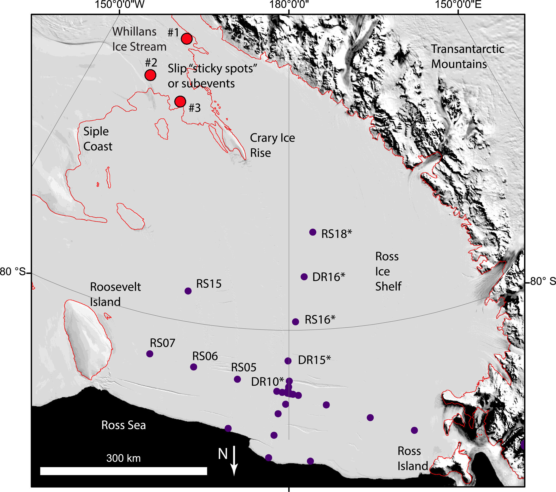
Researchers have discovered that the Ross Ice Shelf, the largest ice shelf in Antarctica, lurches forward 6 to 8 centimeters once or twice a day due to movements of the Whillans Ice Stream. This movement, triggered by slip events, could potentially play a role in triggering icequakes and fractures in the ice shelf. While not directly related to human-caused global warming, the stability of Antarctica's ice shelves in a warming world is a concern, as their collapse would lead to faster glacier flow and contribute to sea level rise.
A study published in Geophysical Research Letters found that late-season melting events on the Greenland Ice Sheet have minimal impact on its annual motion, despite causing temporary accelerations in ice flow. The research, led by Ryan Ing and colleagues, used satellite imagery and meteorological data to analyze the effects of intense melting events in 2022. While these events led to short-lived increases in ice motion, they did not significantly affect the overall annual ice discharge. However, the study highlighted the significant role of late-season melt events in intensifying surface melting and increasing annual meltwater runoff, which could have broader implications for ice sheet mass loss as Earth's climate continues to warm.
New maps based on six years of data from a national lightning detection network reveal that the United States averages 23.4 million flashes, 55.5 million strokes, and 36.8 million ground strike points from lightning each year. The Gulf Coast experiences the most lightning activity, particularly in Florida, while the Central and Southern U.S. also see frequent thunderstorms. The data, which is crucial for improving forecasts and damage prevention, can help meteorologists, emergency management teams, and engineers enhance safety measures and better understand how lightning affects different regions.
Research on deep-sea sediments from the Cenomanian period (~93.5 million years ago) suggests that Oceanic Anoxic Event 2 (OAE2) was caused by volcanic activity and climate warming, leading to widespread ocean anoxia. The study reveals a significant increase in total organic carbon content and sea surface temperature during this period, indicating a decline in oxygen levels. The findings highlight the potential future expansion of oxygen minimum zones in today's oceans due to global warming, posing a threat to marine ecosystems and biodiversity. Understanding past episodes of marine anoxia is crucial for guiding decisions to safeguard the future of Earth's oceans amidst ongoing climate change.
A new study has used an 850-year pollen record from Greenland to investigate the impact of climate and human activity on boreal ecosystems, particularly in high-latitude regions. The research reveals changes in pollen composition coinciding with the transition from the Medieval Warm Period to the Little Ice Age, indicating the influence of both climate and human exploitation of forests. The findings suggest that human impact, such as logging and forest exploitation, had a significant effect on the landscape, outweighing the impact of climate change. As Arctic ecosystems continue to be rapidly altered by climate change, the study highlights the complex interplay between climate and human activity in shaping the environment.
New research suggests that erosion rates in the European Alps may be declining in recent decades/centuries compared to over 10,000 years ago, attributed to reduced glacial load and climate warming. The study, focusing on rockwall erosion, found that higher erosion rates occurred in the middle to late Holocene, with a rapid decline in erosion rate over the past five decades. The researchers attribute this decline to a combination of increased frost cracking, thawing of permafrost, and landscape adjustment to glacial ice unloading. The findings are important for understanding the impact of deglaciation in a warmer world on rock erosion and rockfall events as climate change continues.
Scientists at British Antarctic Survey are using satellite images to track the colossal iceberg A23a as it moves north out of the Weddell Sea, with a new animation showing its trajectory alongside previous large icebergs A68 and A76a. The iceberg, which calved from the Filchner Ice Shelf in 1986, was recently observed by scientists aboard RRS Sir David Attenborough, who collected seawater samples from the area. The animation has been compiled from Copernicus Sentinel-3 satellite imagery, providing valuable insights into the iceberg's movement.
The Paratethys, an ancient lake that existed about 11.6 million years ago, has been recognized as the largest lake in Earth's history by the Guinness Book of World Records. Stretching from Austria to Turkmenistan, it contained 10 times more water than all of Earth's modern lakes combined. The lake dried up over millions of years, leaving behind remnants such as the Black Sea, Caspian Sea, and Aral Sea. Studying the Paratethys provides insights into climate fluctuations and how present climate change could impact our water sources and environment.
Researchers have discovered evidence that Antarctica's ice sheets grew and receded more frequently during the Miocene epoch than previously known, with cycles of growth and recession occurring over just a few thousand years. This rapid volatility raises questions about the causes behind it. The findings, based on sediment records from the Antarctic Drilling Project, provide valuable insights into the behavior of ancient ice sheets and have implications for understanding the potential future changes in Antarctica's ice sheets under a warming climate. The fate of these ice sheets has significant consequences for global sea levels, ocean currents, marine food webs, and regional climates.
Researchers have developed a more accurate prediction of past Antarctic ice sheet melt, providing a realistic forecast of future sea level rise. By studying historical records and fossilized sea-level markers in Australia, the team determined that the Antarctic ice sheet contributed 9.8 meters to sea level during the Mid-Pliocene era, reducing previous estimates of global mean sea level rise by 2100 to between 5 and 9cm. The improved modeling will help inform policy and aid in the protection of coastal and low-lying communities vulnerable to even small changes in sea level.
A modeling study predicts that in 250 million years, a supercontinent called Pangea Ultima will form, resulting in extreme temperatures that will make the new landmass uninhabitable for mammals, including humans. The study suggests that increased volcanism and a hotter sun will lead to drastic temperature increases, creating a hostile environment devoid of food and water sources. Only a small portion of the supercontinent's land mass is expected to remain habitable. The findings highlight the potential impact of natural processes on Earth's climate in the distant future and the limitations of mammalian adaptation to extreme heat.
The Copernicus Sentinel-2 image showcases the Southern Patagonian Ice Field, one of the largest ice masses on Earth outside the polar regions. Stretching across the Patagonian Andes, the ice field feeds various glaciers, including the Perito Moreno Glacier and the Grey Glacier. The area's aquamarine lakes are fed by melting glaciers, and the sediment in the water, known as "glacier milk," varies its color. The moraines, rock and debris deposits left by the glaciers, can be seen in the image. Glaciers are crucial indicators of climate change and their retreat contributes to rising sea levels, making satellite data essential for monitoring their changes.
New research published in Nature Communications explains why and when the Sahara Desert experienced periodic green phases. Climate scientists used a climate model to simulate the North African Humid Periods and found that changes in Earth's orbital precession, which influenced the strength of the West African Monsoon system, were responsible for these humid events. The study also revealed that the humid periods did not occur during ice ages when large glacial ice sheets covered high latitudes, suppressing the expansion of the African monsoon system. Understanding these mechanisms provides insights into the dispersal of species, including early humans, out of Africa during different climatic periods.
A multinational team of researchers has used data from multiple sources to map the pathways of warm water that reaches the cavity of East Antarctica's Totten Glacier. The study provides valuable insights into the physical processes controlling the melting of the glacier and highlights the importance of bathymetry and regional circulation in regulating ocean heat transport. The findings can help improve modeling and understanding of the glacier's contribution to global sea-level rise.
A new study has revealed that the rapid extraction of groundwater by humans has caused a significant shift in the Earth's tilt. Between 1993 and 2010, the tilt of the Earth shifted by 31.5 inches, corresponding to global withdrawals of underground water. The displacement of this water, which is often used for irrigation and eventually flows into the oceans, has occurred faster than aquifer replenishment. The study suggests that groundwater depletion has the largest impact on the drift of the Earth's rotational pole, highlighting its significant role in sea level rise. To conserve groundwater, individuals can take actions such as choosing water-saving plantings, repairing leaks promptly, and using water-saving products.