Tag

Severe Thunderstorm Watch

All articles tagged with #severe thunderstorm watch

weather1 year ago

Severe Storms Expected to Disrupt Memorial Day in NYC

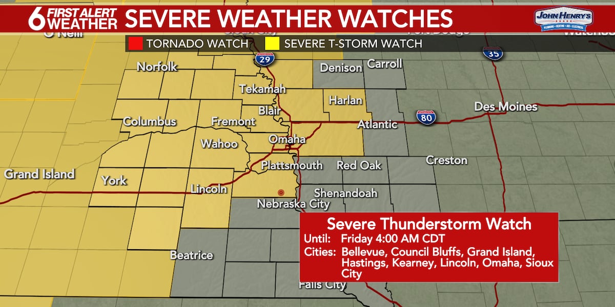
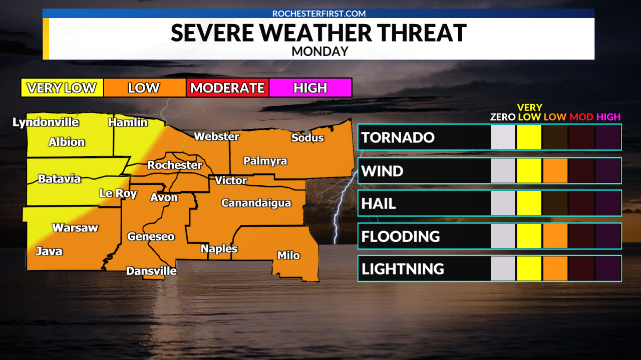
A Severe Thunderstorm Watch is in effect for Wayne and Yates Counties until 9pm, with isolated storms possible this afternoon. The main band of storms is moving eastward, and additional development is expected. Temperatures will be in the 70s, dropping to the lower 60s overnight. More rain and thunderstorms are expected on Tuesday, with cooler temperatures. High pressure will bring drier conditions later in the week.

weather1 year ago

Severe Storms and Tornadoes Hit Nebraska and Iowa Overnight

A Severe Thunderstorm Watch has been issued for the Omaha Metro area until 4AM Friday, with the main threat of strong storms occurring between midnight and 4AM. Damaging winds up to 75 mph and possible quick spin-up tornadoes are expected, along with an increased risk of flooding due to recent heavy rains. The storm line should clear by Friday morning, leading to a quiet and cool day with a high near 70 degrees. Memorial Day Weekend is expected to start dry, with a chance of storms by Saturday evening.

weather1 year ago

Severe Thunderstorm Watch for D.C. Area Until 8 PM

The D.C. area is under a severe thunderstorm watch until 8 p.m. due to high temperatures and humidity, with potential for damaging winds, hail, lightning, and heavy rain. Scattered thunderstorms are expected through the evening, possibly lasting until midnight. Residents should be prepared for severe weather and seek shelter if a warning is issued. Overnight lows will range from the mid-60s to near 70, with patchy fog possible. Tomorrow's weather may see fewer storms due to cloudier skies.

weather1 year ago

"Michigan Counties on Alert: Severe Storms and Tornadoes Expected"

A severe thunderstorm watch is in effect for most of southern Lower Michigan until 7 p.m., with a fast-moving line of severe storms already formed and moving east across the region. The storms are expected to hit quickly and be over rapidly, with the most severe part lasting only a few minutes. The main threats include brief gusts of around 60 mph, large hail, and the possibility of isolated tornadoes. Residents are advised to seek shelter indoors and stay updated on the rapidly changing radar imagery.

weather2 years ago

Severe Thunderstorm Watch and First Alert Weather Day for Texas on Sunday

The National Weather Service and Storm Prediction Center have issued a Severe Thunderstorm Watch until 11pm for the Northern Brazos Valley, including Milam, Robertson, and Leon Counties. The watch may be extended further south if necessary. The main impacts expected are strong, damaging wind gusts exceeding 60-70mph and hail up to the size of a quarter or half dollar. There is a possibility of hail up to the size of an egg or tennis ball, particularly north and northwest of the Brazos Valley. Thunderstorms are developing along a boundary to the north of the area, with the greatest severe weather concerns expected as the storms develop. The severe weather concern should transition to a wind potential as the storms form into a line during the late evening and overnight hours.

weather2 years ago

Severe Thunderstorm Watch blankets D.C. area and surrounding regions

A severe thunderstorm watch has been issued for the D.C. area until 9 p.m. as temperatures soar to near-record highs and a cold front approaches. Strong to severe storms are expected to develop, with the greatest concentration likely to the north and west of the District. Scattered showers and storms are possible through the evening, with the potential for isolated damaging gusts, small hail, frequent lightning, and heavy rainfall. Tomorrow will bring partly to mostly sunny skies with a chance of late-day showers and storms.

weather2 years ago

Severe thunderstorm watch and unseasonably cool weather expected in Kansas and Missouri

A severe thunderstorm watch has been issued for parts of Kansas and Missouri until 2 a.m. Monday, with the potential for 70 mph winds and ping-pong-sized hail. Gusty winds and heavy rainfall have already caused minor tree damage and power outages in the area. The Kansas City NOAA Weather Radio Transmitter is currently down due to a communication line failure. The storms are expected to move out of the metro by around 10 p.m.

weather2 years ago

Stormy Sunday: Severe Thunderstorm Watch and More Storms Expected

A Severe Thunderstorm Watch has been issued for the extreme southwestern edge of the viewing area until 11:00pm, with the threat of large hail and damaging wind gusts. However, the risk for severe weather in the Kansas City area has greatly diminished. Showers and storms will gradually taper off, with a small chance of new storms developing tonight. Cooler temperatures and drier air are expected for Monday, with highs in the low to mid 70s. Tuesday will be pleasant with sunshine and highs in the mid to upper 70s, but temperatures will gradually climb towards 90 degrees by the next weekend.

weather2 years ago

Stormy Weather Ahead: Anticipating the Next Round of Storms

The Severe Thunderstorm Watch has been canceled, but a Flash Flood Watch has been issued for Northeast Ohio due to heavy rain. High water on some roadways has been reported. More than a dozen counties are under a flood watch until Saturday morning. Lingering showers are expected early Saturday, with a chance of general thunderstorms in the afternoon. Sunday is expected to have quiet conditions with temperatures in the 70s.

weather2 years ago

"Intense Severe Thunderstorms Threaten Minnesota and Wisconsin"

The National Oceanic and Atmospheric Administration's Storm Prediction Center has issued a severe thunderstorm watch until 9 p.m. for central and northeastern Minnesota and northwestern Wisconsin, including the northern Twin Cities, St. Cloud, Brainerd, Duluth, and parts of western Lake Superior. The primary threats include widespread large hail, isolated very large hail events up to 3 inches in diameter, and scattered damaging wind gusts up to 70 mph, with a possibility of a tornado or two. Thunderstorms are expected to rapidly develop and track southeastward across the watch area.

weather2 years ago

Severe Thunderstorm Watch: Lower Michigan Counties Brace for 75 mph Wind Gusts

A severe thunderstorm watch has been issued for 27 counties in Lower Michigan, with concerns of isolated very strong wind gusts reaching up to 75 mph. The watch also warns of scattered damaging winds, isolated large hail events, and the possibility of a tornado. Multiple clusters of intense thunderstorms are expected to move across the region, posing a risk of damaging winds and hail.

weather2 years ago

Impending Severe Storms Threaten Minnesota and Wisconsin

The National Weather Service's Storm Prediction Center has issued a severe thunderstorm watch for most of central and northern Minnesota and northwest Wisconsin until 10 p.m. The storms are expected to produce large hail, damaging winds exceeding 60 mph, and there is a possibility of tornadoes. Residents in the affected areas are advised to stay alert and be prepared for severe weather warnings.