Severe Storms and Tornadoes Hit Nebraska and Iowa Overnight
TL;DR Summary
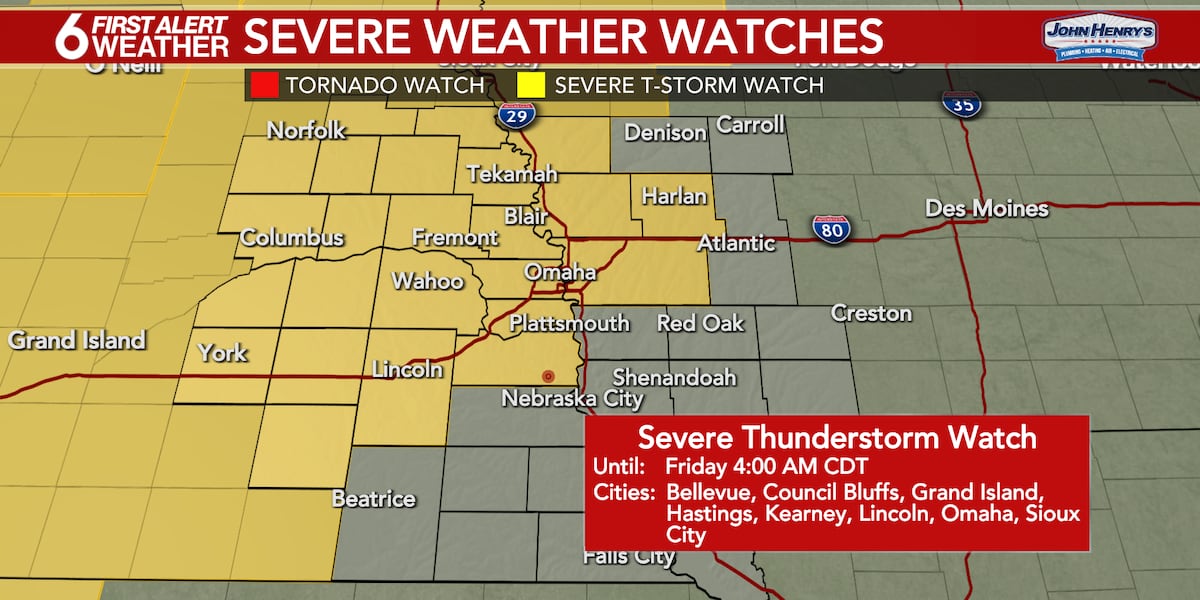
A Severe Thunderstorm Watch has been issued for the Omaha Metro area until 4AM Friday, with the main threat of strong storms occurring between midnight and 4AM. Damaging winds up to 75 mph and possible quick spin-up tornadoes are expected, along with an increased risk of flooding due to recent heavy rains. The storm line should clear by Friday morning, leading to a quiet and cool day with a high near 70 degrees. Memorial Day Weekend is expected to start dry, with a chance of storms by Saturday evening.
Topics:nation#flood-watch#memorial-day-weekend#omaha#overnight-storms#severe-thunderstorm-watch#weather
- 6 FIRST ALERT WEATHER DAY: A Severe Thunderstorm Watch has been issued ahead of overnight storm chances WOWT
- Tornado warnings were issued for severe storms in Nebraska, Iowa early Friday morning KETV Omaha
- Nebraska braces for severe storms with large hail and potential tornadoes tonight NTV
- Multiple tornados rip through area Thursday night; damage near Lake McConaughy North Platte Post
- WEATHER ALERT DAY: Tornado Warnings roll through eastern Nebraska early Friday morning KOLN
Reading Insights
Total Reads
0
Unique Readers
8
Time Saved
1 min
vs 2 min read
Condensed
70%
292 → 89 words
Want the full story? Read the original article
Read on WOWT