"Intense Severe Thunderstorms Threaten Minnesota and Wisconsin"
TL;DR Summary
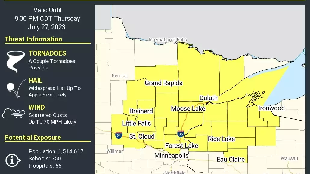
The National Oceanic and Atmospheric Administration's Storm Prediction Center has issued a severe thunderstorm watch until 9 p.m. for central and northeastern Minnesota and northwestern Wisconsin, including the northern Twin Cities, St. Cloud, Brainerd, Duluth, and parts of western Lake Superior. The primary threats include widespread large hail, isolated very large hail events up to 3 inches in diameter, and scattered damaging wind gusts up to 70 mph, with a possibility of a tornado or two. Thunderstorms are expected to rapidly develop and track southeastward across the watch area.
Topics:nation#damaging-winds#hail#minnesota#severe-thunderstorm-watch#storm-prediction-center#weather
- Severe thunderstorm watch until 9 p.m. includes northern Twin Cities, St. Cloud, Brainerd, Duluth MPR News
- Severe storms could be 'unusually intense' in Minnesota, Wisconsin Thursday Bring Me The News
- Severe Thunderstorm Watch Issued Until 9:00 pm WJON News
- Lightning show brings damaging summer storm as wind clobbers local communities Mitchell Republic
- Brandon Weatherz: Updated severe weather risk Thursday WDIO
- View Full Coverage on Google News
Reading Insights
Total Reads
0
Unique Readers
0
Time Saved
1 min
vs 2 min read
Condensed
67%
266 → 89 words
Want the full story? Read the original article
Read on MPR News