Tag

Damaging Wind Gusts

All articles tagged with #damaging wind gusts

"Severe Weather Alert: Strong Winds and Heavy Rain Expected in Northeastern U.S."
weather2 years ago

"Severe Weather Alert: Strong Winds and Heavy Rain Expected in Northeastern U.S."

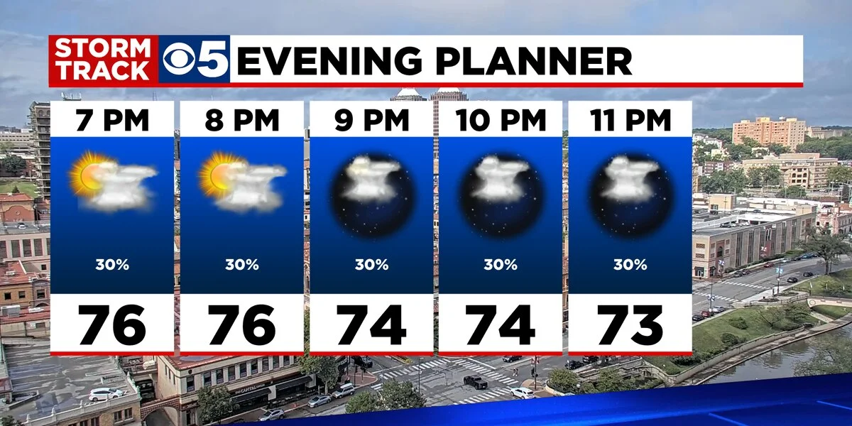
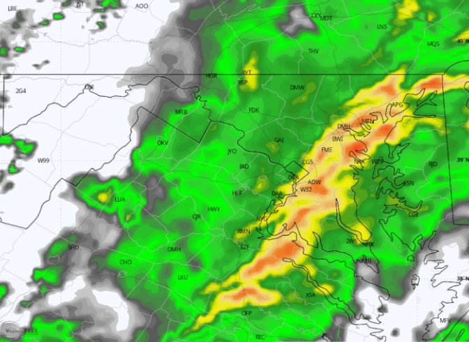
The D.C.-area forecast predicts mild and breezy weather with occasional showers and a chance of thunder, along with a burst of strong evening winds and a significant temperature drop. Tomorrow will be colder with lingering breezes, followed by a trend towards warmer weather starting Friday with the possibility of more showers.

Severe Storms Expected: Another Rainy Weekend Ahead
weather2 years ago

Severe Storms Expected: Another Rainy Weekend Ahead

A First Alert Weather Day has been issued for the threat of strong to severe storms developing this afternoon through early Sunday morning in Alabama. The main concerns include damaging wind gusts, locally heavy rainfall, flash flooding, and spin-up tornadoes. Residents are advised to have their severe weather plan in place and stay updated on warnings. Lingering light rainfall is expected on Sunday morning before colder and drier air moves in, bringing gradually clearing skies and breezy winds. Monday morning may bring patchy dense fog and freezing fog, with isolated icy spots possible. Monday afternoon will see sunshine and temperatures in the upper 40s.

Georgia Faces Severe Storms and Tornadoes Threat on Tuesday
weather2 years ago

Georgia Faces Severe Storms and Tornadoes Threat on Tuesday

North Georgia is at Level 1 risk for severe storms and isolated tornadoes on Tuesday, with heavy rain, damaging wind gusts, and a low but not zero chance of a brief tornado. The rain will start in the morning and continue throughout the day, potentially causing a wet commute. Stay updated with WSBTV.com and Channel 2 Action News for the latest information on the timing and impacts of the storms.

Impending Severe Weather Threatens Central Florida with Heavy Rain, Lightning, and Damaging Winds
weather2 years ago

Impending Severe Weather Threatens Central Florida with Heavy Rain, Lightning, and Damaging Winds

Central Florida is under a Storm Alert Day due to the potential for severe storms, including heavy rain, frequent lightning, damaging wind gusts, and isolated tornadoes. The storms are expected to start in the southwestern portion of the area and move north and east throughout the evening. Tropical moisture and a warm front are contributing to the weather conditions. The region may see 2-4+ inches of rain, with some areas possibly receiving up to 7 inches. Additionally, Tropical Storm Sean has formed in the Atlantic Ocean, while a tropical wave off the west coast of Africa has a 20% chance of further development.

Severe Thunderstorm Watch and First Alert Weather Day for Texas on Sunday
weather2 years ago

Severe Thunderstorm Watch and First Alert Weather Day for Texas on Sunday

The National Weather Service and Storm Prediction Center have issued a Severe Thunderstorm Watch until 11pm for the Northern Brazos Valley, including Milam, Robertson, and Leon Counties. The watch may be extended further south if necessary. The main impacts expected are strong, damaging wind gusts exceeding 60-70mph and hail up to the size of a quarter or half dollar. There is a possibility of hail up to the size of an egg or tennis ball, particularly north and northwest of the Brazos Valley. Thunderstorms are developing along a boundary to the north of the area, with the greatest severe weather concerns expected as the storms develop. The severe weather concern should transition to a wind potential as the storms form into a line during the late evening and overnight hours.

Stormy Sunday: Severe Thunderstorm Watch and More Storms Expected
weather2 years ago

Stormy Sunday: Severe Thunderstorm Watch and More Storms Expected

A Severe Thunderstorm Watch has been issued for the extreme southwestern edge of the viewing area until 11:00pm, with the threat of large hail and damaging wind gusts. However, the risk for severe weather in the Kansas City area has greatly diminished. Showers and storms will gradually taper off, with a small chance of new storms developing tonight. Cooler temperatures and drier air are expected for Monday, with highs in the low to mid 70s. Tuesday will be pleasant with sunshine and highs in the mid to upper 70s, but temperatures will gradually climb towards 90 degrees by the next weekend.

Increasing Threat of Severe Thunderstorms and Tornadoes Across Upstate NY and NYC
weather2 years ago

Increasing Threat of Severe Thunderstorms and Tornadoes Across Upstate NY and NYC

The Storm Prediction Center has announced an 80% chance of issuing a severe thunderstorm watch for the midsection of Upstate New York, with the potential for damaging wind gusts and isolated tornadoes. A tornado watch has already been issued for six Upstate New York counties. The atmospheric conditions are favorable for severe storms, with high levels of instability and the presence of necessary ingredients for thunderstorms. The storms are most likely to develop this afternoon and could persist into Tuesday.

Severe Storms and Extreme Heat Expected in NC and SC
weather2 years ago

Severe Storms and Extreme Heat Expected in NC and SC

The Triangle area in North Carolina is facing a rare level 3 severe weather risk, with the potential for damaging wind gusts, hail, and isolated tornadoes. A heat advisory is also in place, with feels-like temperatures expected to exceed 105 degrees. Dry and slightly more comfortable conditions are expected overnight, but the next chance for storms is on Thursday.

Weekend Forecast: Severe Storms Threaten Multiple States
weather2 years ago

Weekend Forecast: Severe Storms Threaten Multiple States

A potent low pressure system is expected to bring severe weather, including damaging wind gusts and a few tornadoes, to the Midwest and Northeast this weekend. The storm track will be closer to an autumn-like pattern, with the potential for severe weather south of the storm track where a cold front will undercut summer-like humidity and strong winds aloft. The threat of severe storms will be highest on Saturday in parts of Iowa, Kansas, Missouri, and Nebraska, and on Sunday in the Midwest, including Illinois, Indiana, and southern Wisconsin. By Monday, the main threat will be damaging wind gusts in the interior Northeast.

Severe Storms and Tornadoes Threaten Midwest and South.
weather2 years ago

Severe Storms and Tornadoes Threaten Midwest and South.

Severe storms, including tornadoes, hail, and damaging wind gusts, are expected to impact millions of people from the Ohio Valley to the South on Sunday. The tornado threat is highest across portions of eastern Indiana and western Ohio southward into northern parts of Kentucky. Hail that is 2 inches or larger in diameter is possible in portions of eastern Indiana, western Ohio, north-central Kentucky, and central Arkansas and eastern Oklahoma. Damaging wind gusts will also be a concern in the same areas where severe weather is expected. People in these areas should monitor conditions and be prepared to seek shelter.

Severe Storms Threaten Arkansas with First Alert Weather Day.
weather2 years ago

Severe Storms Threaten Arkansas with First Alert Weather Day.

Central and southern Virginia are under a slight risk of severe weather on Monday, with damaging wind gusts being the primary threat. A line of storms is expected to move from northwest to southeast across the Commonwealth in the afternoon, with the timing of severe storms looking like 4 to 8 pm. Hail, lightning, downpours, and localized flooding are also concerns, with an isolated tornado not completely ruled out. Stay prepared by downloading the NBC12 First Alert Weather app.

Severe Thunderstorms and Tornadoes Possible in Rochester and WNY Today.
weather2 years ago

Severe Thunderstorms and Tornadoes Possible in Rochester and WNY Today.

The National Weather Service in Buffalo has warned residents in the Rochester region to brace for several rounds of thunderstorms today and tonight, with some potentially becoming strong to severe this afternoon and evening. The primary threat will be damaging wind gusts, although large hail and a tornado or two are also possible in western New York. Rochester Gas and Electric has pre-staged 150 additional line crews in western New York to assist with restoration efforts, if needed.