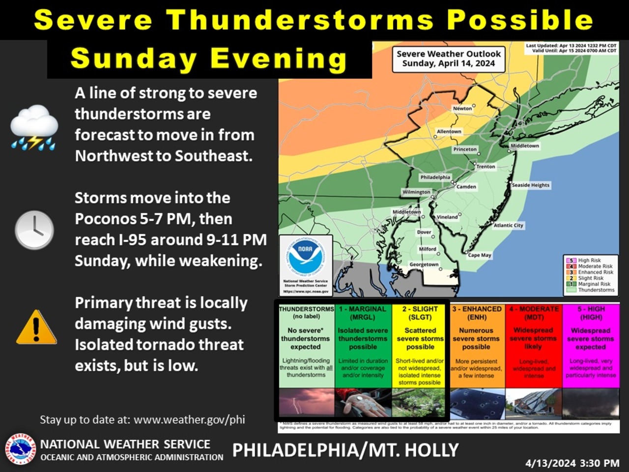
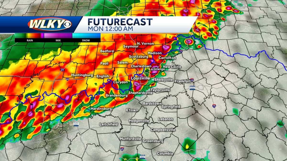
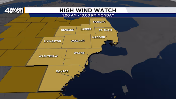
A severe storm system is expected to impact Southeast Michigan with heavy rain, damaging winds, snow squalls, and rapid temperature drops, leading to hazardous travel and power outages, especially on Monday. Residents are advised to prepare for strong winds, icy roads, and rapidly changing conditions, with ongoing cold weather into the New Year.
A complex storm system is expected to impact New Jersey on Wednesday and Thursday, bringing 1 to 3 inches of rain, wind gusts up to 50 mph, and potential minor flooding, with gusty winds continuing through Halloween.
A destructive severe weather event in the TN Valley caused trees and wires to fall across the area, prompting alerts for damaging winds and widespread damage.
A Severe Thunderstorm Watch has been issued for parts of the Northeast, including New York City and Washington, D.C., as strong storms with damaging winds, large hail, and potential tornadoes are expected. The storms, which follow severe weather in the Midwest, could cause significant wind gusts and isolated flash flooding, particularly in the Ohio Valley. The threat extends through Wednesday, affecting major cities along the Interstate 95 corridor.
Powerful storms are expected to hit Upstate New York this afternoon, bringing heavy rain and damaging winds, particularly east of the Finger Lakes. The National Weather Service warns of potential localized flooding and wind gusts up to 60 mph, with the strongest winds likely in the Buffalo area and Tug Hill Plateau. The storms are expected to subside by 8 p.m. in Central New York and by 11 p.m. in the Capital Region.
Numerous central Ohio counties are under a severe thunderstorm watch until 8 p.m. Sunday, with two primary rounds of storms expected. The first round will hit by late afternoon, and the second will arrive late Sunday night into early Memorial Day Monday. The main threats include strong damaging winds, large hail, and isolated flooding, with a small risk of tornadoes. Showers and thunderstorms will continue into Monday morning, with scattered showers expected through the first half of the week before sunny weather returns by Thursday.
Severe thunderstorms are expected on Sunday with a severe alert day issued. The Storm Prediction Center has placed the entire WLKY area under an Enhanced Risk for severe storms, with damaging winds, hail, and isolated tornadoes possible. The storms will come in two rounds: midday to early afternoon and Sunday night, with the latter posing the greatest risk, including wind gusts above 70 mph. Stay tuned for updates.
Severe storms with damaging winds, hail, and flooding are expected to stretch from the Midwest to Texas on Thursday, with a Level 3 risk area including parts of Missouri, Illinois, Indiana, Kentucky, and Tennessee. The threat of tornadoes is not ruled out, and a Severe Thunderstorm Watch has been issued for several areas. The slow-moving cold front and recent heavy rainfall over the Ohio Valley may lead to flooding, while unusually cold air is expected to follow the cold front, bringing below-average temperatures to several regions.
The Midwest is preparing for severe thunderstorms, possible tornadoes, and destructive winds on Monday and Tuesday, with a wide area from northern Texas to South Dakota at risk. Over 1.5 million residents of Nebraska and Kansas are under an enhanced risk, while more than 12 million people in Oklahoma, Missouri, and northern Texas face a slight risk. The storm system could bring large hail, damaging winds, and potential tornadoes, with the threat extending to the Ohio Valley and Mid-Atlantic. Additionally, high winds increase the risk of wildfires in parts of the Southwest and the Plains.
A Yellow Alert has been issued for Sunday evening in New York, particularly for areas north and west of the city, as a line of showers and embedded storms is expected to move in after 6 p.m., potentially bringing damaging wind gusts, small hail, and isolated tornadoes. The storms are forecasted to weaken as they move southeastward, with the best chance of severe weather being north and west of the city. The rest of the work week is expected to be mostly sunny and warm.
Severe thunderstorms are expected to bring damaging winds, hail, and possibly an isolated tornado from the Great Lakes to the Northeast on Sunday, with a heightened threat in the Heartland early in the week. The Storm Prediction Center is monitoring the chance for severe thunderstorms from Ohio to Connecticut, including most of Pennsylvania. Additionally, temperatures are forecasted to soar well above average across the western half of the country, with near record-high temperatures possible, before moderating midweek.
The National Weather Service has warned of powerful thunderstorms with damaging winds up to 70 mph and the possibility of an isolated tornado hitting parts of northwest New Jersey Sunday night, with an Enhanced Risk for severe thunderstorms in Carbon and Monroe counties in Pennsylvania and a Slight Risk extending across northwest New Jersey and the Lehigh Valley. The line of thunderstorms is projected to approach the Poconos between 5 and 7 p.m. Sunday and move into northwest New Jersey between 7 and 9 p.m.
Confidence is increasing in severe storms early Wednesday morning in the Houston area, with potential for damaging winds, hail, and tornadoes. The line of storms is expected to move from west to east across the metro area between 3am and 7am CT, with the greatest risk of severe thunderstorms north of Interstate 10. The majority of the area will experience strong winds, intense lightning, and thunder, with the tornado threat greatest to the northeast of Houston. The storms are likely to clear out by 7am or 8am, but some effects may persist, and the rest of Wednesday is expected to be breezy with no weather concerns.
Severe thunderstorms with potential for damaging winds, large hail, and tornadoes are expected in the Lexington area, prompting a First Alert Weather Day. Residents are advised to stay safe and prepare for the severe weather.
Dangerous storms in the Midwest have produced tornadoes, large hail, and damaging winds, with ongoing severe thunderstorm watches in Illinois and Missouri. The storms are expected to expand into the South, posing a threat of tornadoes, large hail, and damaging winds across Arkansas, Oklahoma, and southern Missouri. The severe weather is expected to decrease as the system moves into the Southeast and southern Plains on Friday.