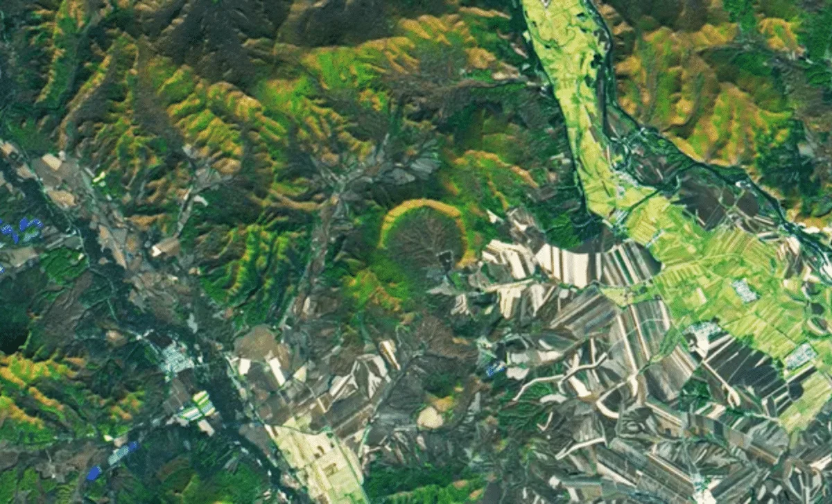
Tag

Landsat 8

All articles tagged with #landsat 8

science-and-environment1 year ago

Satellite Reveals Mysterious 'Goblin Forest' Encircling Sacred Volcano

A satellite image from Landsat 8 has captured Mount Taranaki in New Zealand, surrounded by the 'Goblin Forest,' a ring of gnarled kāmahi trees. This forest, named for its eerie appearance, grows over fossilized remains of past trees. Mount Taranaki, an active but currently dormant stratovolcano, holds cultural significance for the Māori people and was granted legal personhood in 2017. The mountain is closely monitored for potential eruptions, with a 30-50% chance of erupting in the next 50 years.

science1 year ago

NASA Investigates Mysterious 'Pet Cloud' Over New Zealand

NASA's Landsat 8 captured a striking image of the 'Taieri Pet,' a lenticular cloud that forms over the Rock and Pillar Range in New Zealand's Otago region. Known for its unique landscapes, New Zealand's atmospheric phenomena like the Taieri Pet add to its otherworldly allure. These stationary clouds form when wind flows over mountains, creating standing waves that condense into visible formations. The Taieri Pet has been a local weather indicator since the 1890s, often signaling incoming storms.

science-and-environment1 year ago

"Spirit Lake: A Serene Beauty"

Spirit Lake in Washington, once devastated by the 1980 eruption of Mount St. Helens, has taken on a new heart-like shape and higher elevation due to the formation of a "new" lake atop debris from the landslide. Tourist attractions from the past are now buried beneath the modern lake, and access is limited to preserve the site for scientific study of the landscape's recovery, including the impact of uprooted trees on the lake's ecosystem.

space2 years ago

Debunking Space Myths: Separating Fact from Fiction.

Maxar Technologies' Worldview-3 satellite has captured rare close-up images of NASA's Landsat 8 spacecraft in orbit, showing clear details of the Earth-observation satellite's solar array and science payloads. The images demonstrate how satellite imagery can be used to check the health of satellites and improve space domain awareness. Both satellites are in similar, near-polar orbits, with Worldview-3 circling around 381 miles above Earth, while Landsat has a higher altitude of 437 miles.

space2 years ago

Satellite Captures Stunning Images of Another Satellite in Orbit.

NASA's Landsat 8 satellite was pictured orbiting Earth by Maxar Technologies' commercial WorldView-3 observation satellite, providing a rare glimpse of a satellite in orbit taken by another satellite. The recent images of Landsat 8 taken by WorldView-3 point to the broader use of satellites to spy on enemy satellites. The ability to manipulate enemy satellites in orbit via other satellites is a quickly growing facet of what is an increasingly contested warfighting domain. Attacks on U.S. assets in space are now a daily occurrence, although the vectors of those attacks remain unclear.