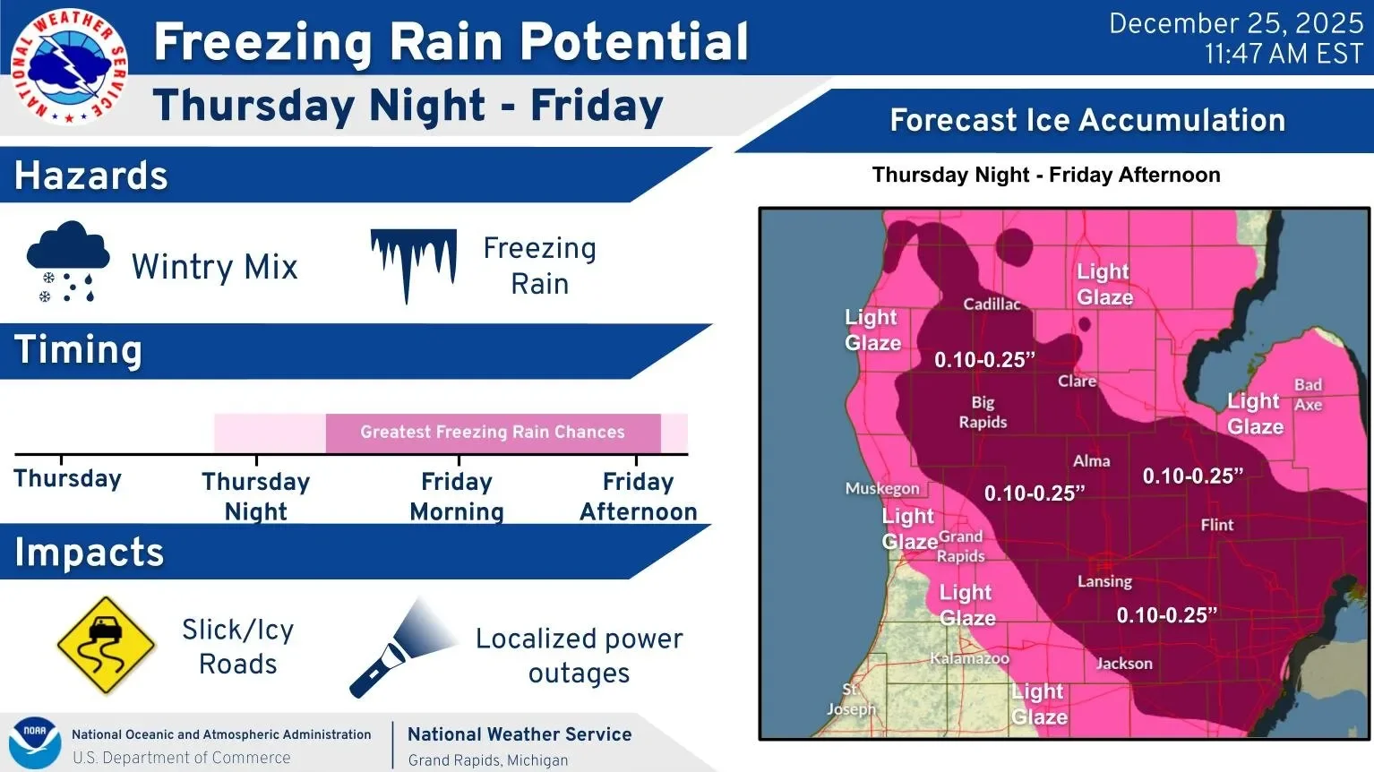
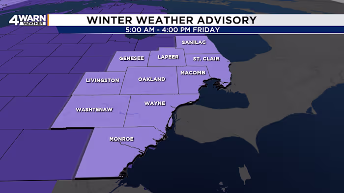
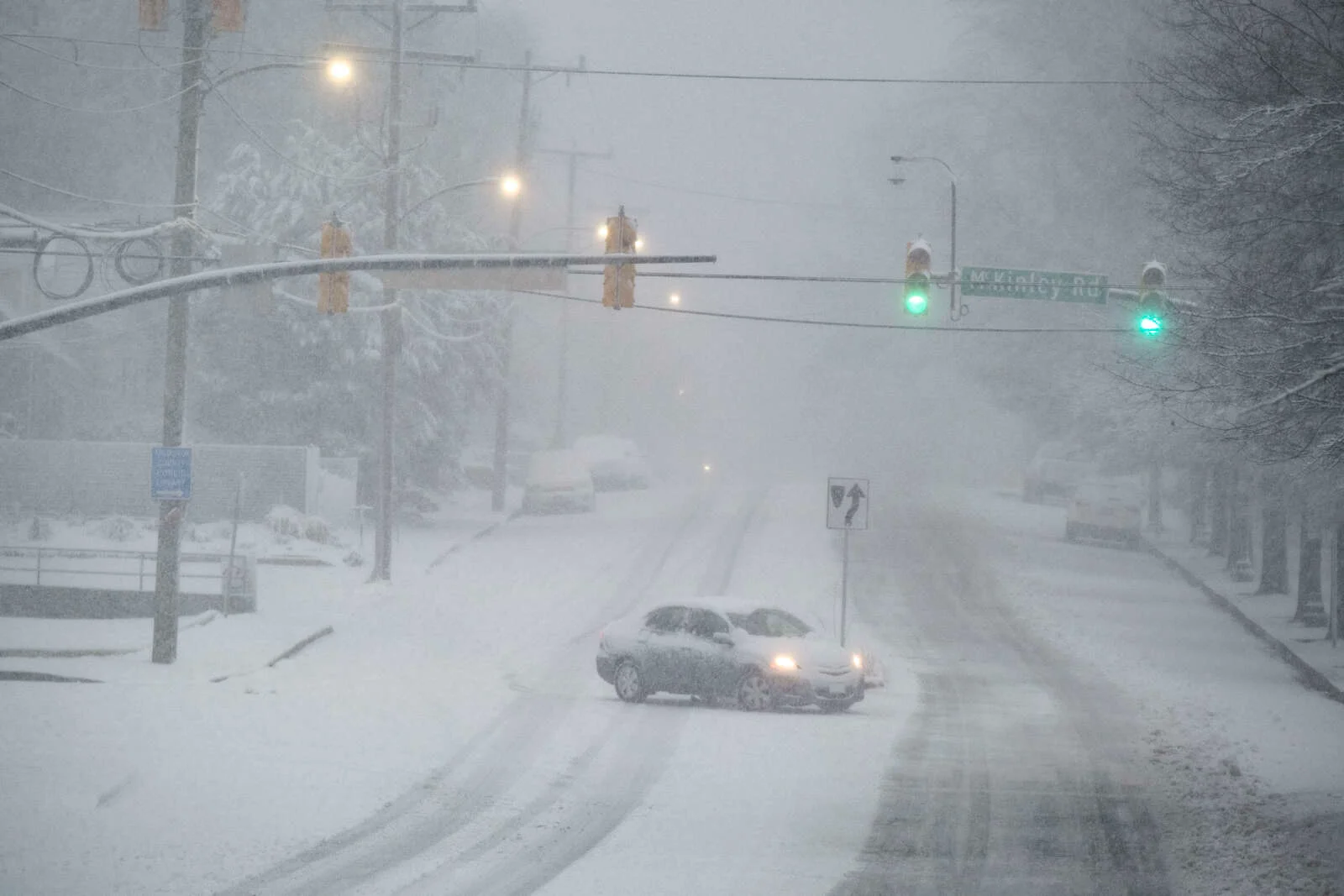
A messy and icy start to Tuesday across Minnesota and western Wisconsin involves freezing rain, fog, and slick conditions, with significant ice accumulation expected in western Wisconsin, leading to winter weather advisories. Temperatures are steady, and a brief warm-up is forecasted for Wednesday, followed by a cooldown and another warm-up early next week.
A winter weather advisory is in effect for Minnesota as a weak low-pressure system causes freezing rain and ice accumulation up to 0.10 inches, potentially leading to hazardous travel and walking conditions overnight into Tuesday, with temperatures warming up by Wednesday.
Warmer temperatures will lead to patchy fog and freezing drizzle, with light snow and icing possible, especially along I-94 and the Twin Cities. A Winter Weather Advisory is in effect, but widespread impacts are unlikely as temperatures remain above average through next week, with only minor precipitation risks.
A significant snowstorm is forecasted for Colorado's high country, with over a foot of snow expected, raising avalanche risks and impacting travel, as a second storm is anticipated to follow, amid below-average snowpack levels and historically warm December temperatures.
A winter weather advisory and hazardous weather outlook have been issued for Colorado's mountains, with snow expected to accumulate through Friday and possibly into Sunday, affecting areas above 8,000 feet and near the Continental Divide.
A weather system brings light snow and colder temperatures to Minnesota on Wednesday, with snow showers ending by early afternoon and temperatures dropping into the teens and single digits, but warming up to seasonable levels by the weekend.
Light rain showers mixed with sleet are affecting the D.C. region on Boxing Day, with a winter weather advisory in effect for parts of Maryland. Most areas will stay above freezing, but some northern regions may experience icy conditions. The weather is expected to improve by midnight, with temperatures rising into the 40s over the weekend and another round of rain forecast for late Sunday.
A winter storm is expected to cause icy roads and travel delays in Northeast Wisconsin, with freezing rain and ice accumulations forecasted for Friday morning, followed by a second system bringing colder temperatures, snow, and gusty winds through the weekend, impacting holiday travel plans.
A Winter Weather Advisory is in effect for parts of Michigan and Indiana due to potential freezing rain and icy roads, especially impacting regional travel after Christmas. While the local area will experience above-freezing temperatures and no significant weather issues, nearby regions may see brief freezing rain and colder temperatures, leading to slick roads. The weather will improve on Saturday, but a cold front and snow are expected early next week.
Forecasters have issued a winter weather advisory for Lansing and much of Lower Michigan for December 26, warning of widespread freezing rain and ice accumulation up to 0.25 inches, which will make travel hazardous throughout the day.
A Winter Weather Advisory has been issued for Southeastern Michigan due to forecasted freezing rain and ice accumulation on Friday, which may impact travel during the holiday weekend, with expected ice buildup of 0.05 to 0.10 inches and temperatures around freezing.
A winter weather advisory is in effect in Minnesota due to the potential for icy roads and freezing drizzle on Christmas Day, especially north of Interstate 94, with up to a tenth of an inch of ice possible. The drizzle is expected to end before sunrise on Friday, with colder temperatures and strong winds forecasted for the weekend, followed by a warming trend next week.
A gloomy and foggy Christmas Day is affecting much of Minnesota, with dense fog, freezing drizzle, and icy travel concerns, especially in the northern regions. While temperatures are relatively warm for late December, a cold Arctic front will bring a sharp drop in temperatures early next week, accompanied by strong winds and dangerously low wind chills.
Upstate New York is experiencing its first widespread snowstorm of the season, with most areas receiving 3 to 6 inches of snow, leading to slippery roads and school closures, as a coastal storm brings moderate to heavy snowfall across the region.
The first lake effect snowstorm of the season is expected to bring heavy snow, strong winds, and difficult driving conditions to Upstate New York, with Syracuse forecasted to receive around 6 inches of snow and wind gusts up to 30 mph, leading to winter weather advisories in the region.