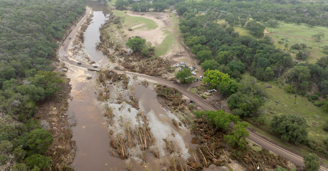
Severe flooding in Texas exposed staffing shortages at the National Weather Service, with key vacancies potentially hindering coordination with local emergency officials during critical flood events, amid debates over forecast accuracy and preparedness.
The National Weather Service in Alaska issued its first-ever heat advisory for Fairbanks, warning of temperatures around 85°F, marking a new approach to alert residents about warm weather, although it is not due to record-breaking temperatures but rather a change in warning procedures.
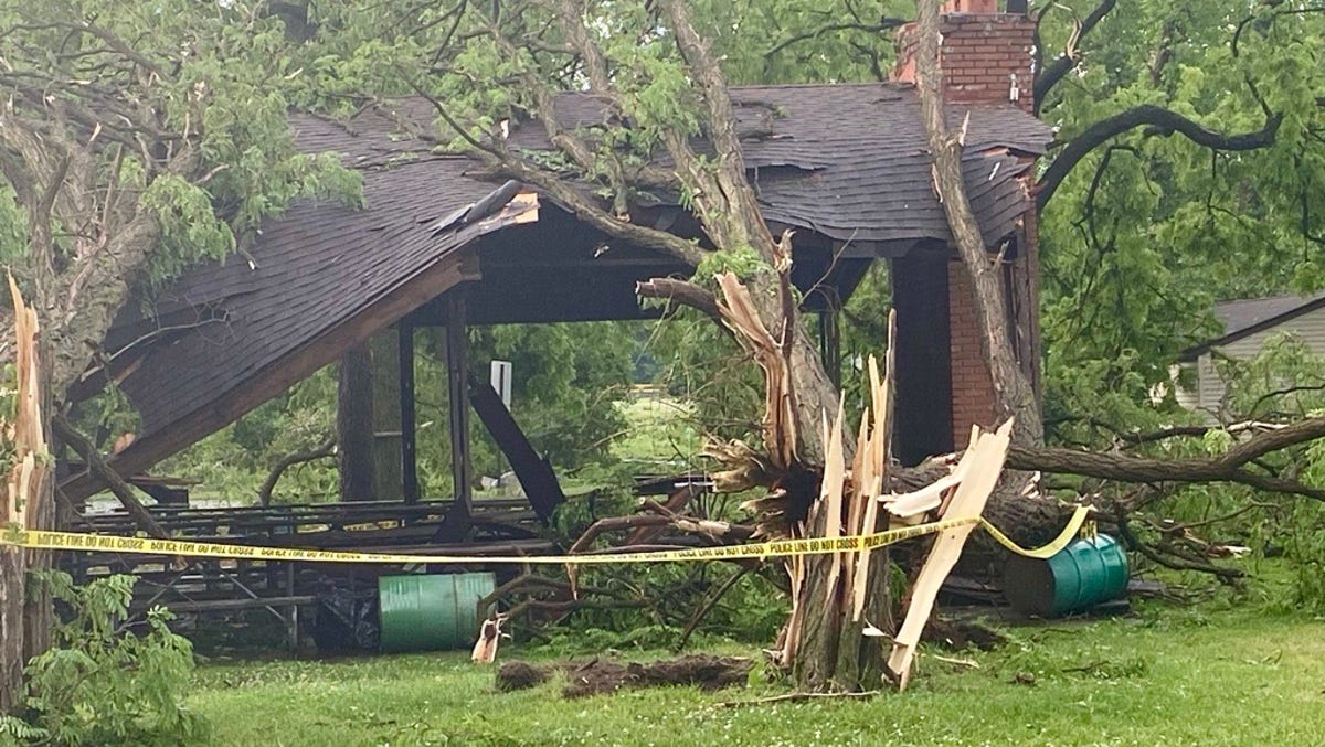
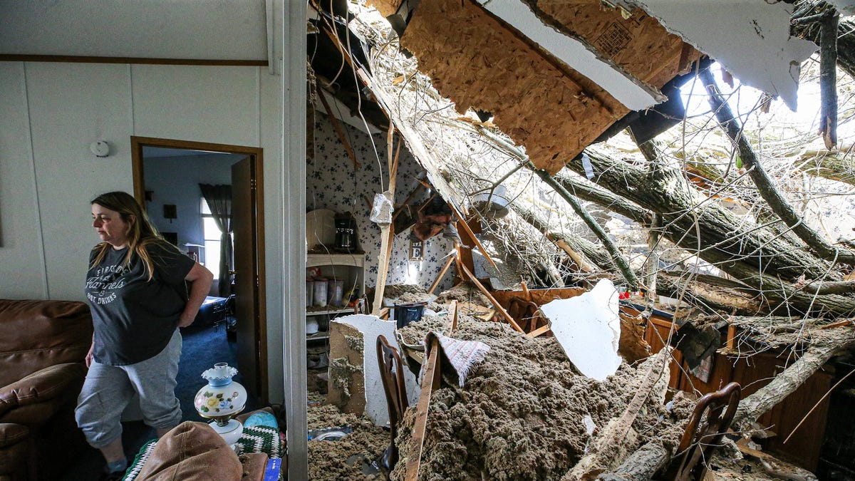
A tornado rapidly swept through Livonia, killing a 2-year-old and injuring his mother and 2-month-old sibling when a tree fell on their home. The National Weather Service did not issue a warning due to the tornado's quick development. The weather service is investigating the tornado's strength and size.
A major spring storm brought heavy snow, rain, and high winds to the Northeast, leaving around 700,000 homes and businesses without power and causing travel disruptions. Maine and New Hampshire bore the brunt of the power outages, with over a foot of snow falling in some areas. The storm also brought heavy rain and high winds to southern portions of the Northeast, leading to numerous accidents and flight cancellations. Cleanup work continued in several states affected by tornadoes and severe weather earlier in the week.
A dangerous half-mile-wide tornado was reported in northern Ohio, with at least three others confirmed in Kentucky and Indiana, causing damage to homes and structures. The National Weather Service issued warnings for tornadic rotations and the possibility of scattered wind gusts up to 70 mph and tennis ball-sized hail. Additional tornadoes wreaked havoc in southern Indiana and north-central Kentucky, damaging structures and causing power outages. The threat of tornadoes and large hail also extended to parts of north-central Texas and the Midwest.
More than 19,000 customers are without power in Central New York due to high winds, with the most outages in Oswego County. The National Weather Service forecasts winds of 50 to 60 mph, leading to downed branches, trees, and utility lines. Outages are concentrated in Syracuse, Oswego, and Stockbridge, with the potential for blizzard-like conditions as rain turns to snow, possibly resulting in several inches of snow and up to a foot in some areas by late Thursday.
Multiple tornado touchdowns were reported in southern Wisconsin, causing damage to over 30 buildings and power lines in Rock and Green counties. No deaths or injuries were reported, but there were numerous reports of tornado activity and funnel clouds. The National Weather Service issued a tornado warning for several counties and is tracking wind rotation for potential tornadoes. The storm also caused power outages and road closures. Additionally, the rare and ongoing "super El Niño" has had a significant impact on weather patterns in the US, with California experiencing heavy rainfall and storms.
A cold Pacific storm is expected to bring 2 to 2.5 inches of rain to San Diego County from Thursday to Friday, potentially causing heavy runoff and urban flooding. The storm may also produce thunderstorms and strong winds, leading to concerns about flash flooding and coastal erosion. The region is still recovering from last week's damaging flooding, and city crews are preparing storm channels. A second major storm is forecasted for Monday and Tuesday, raising the risk of further urban flooding. Residents are advised to stay away from coastal cliffs and prepare for potential impacts, while the county and local cities are providing free sandbags to the public.
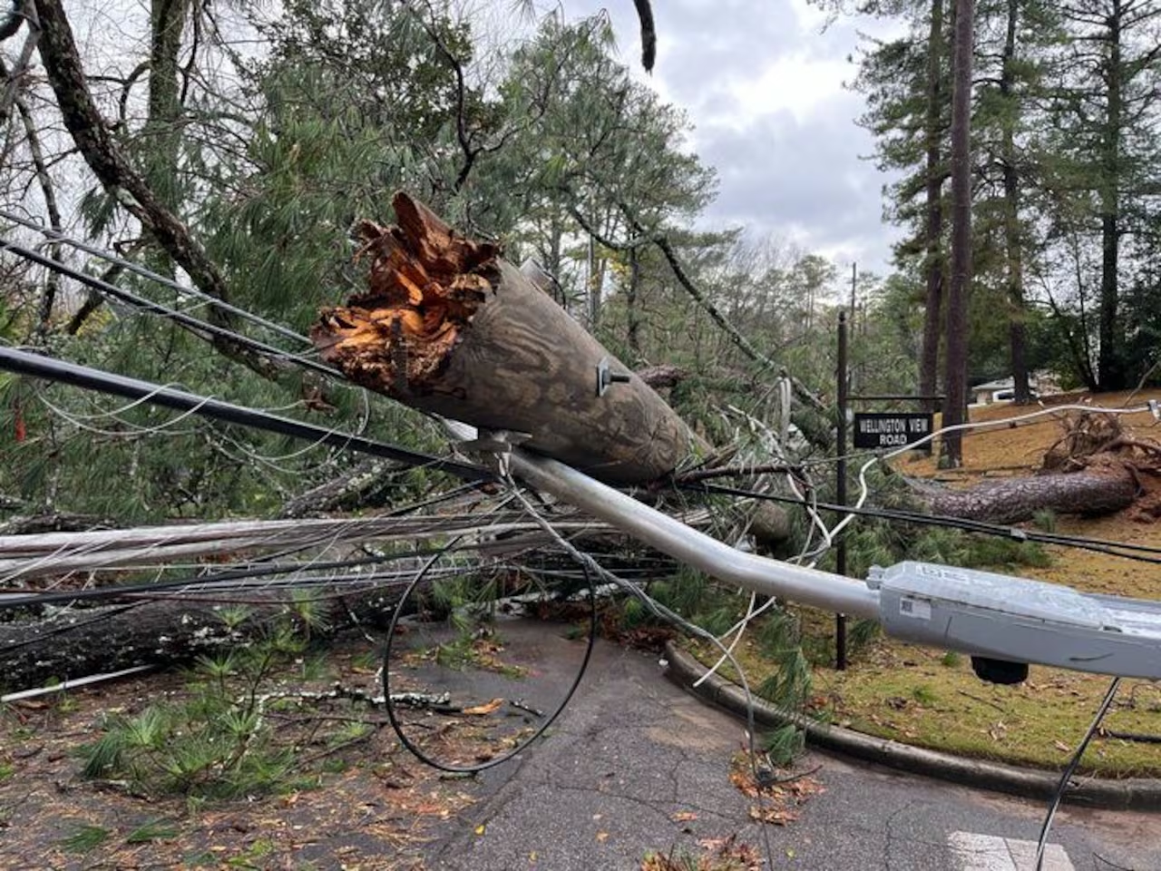
Four tornadoes have been confirmed in Alabama following storms over the weekend, with two in Jefferson County and one each in Lee and Barbour counties. The Barbour tornado crossed into Henry County. The National Weather Service sent survey teams to assess the damage, confirming two tornadoes in Lee and Barbour counties with preliminary ratings of EF-0. Two EF-1 tornadoes were also identified in the south side of Jefferson County. The storms caused extensive damage, but no severe weather is forecasted for Alabama in the coming week.
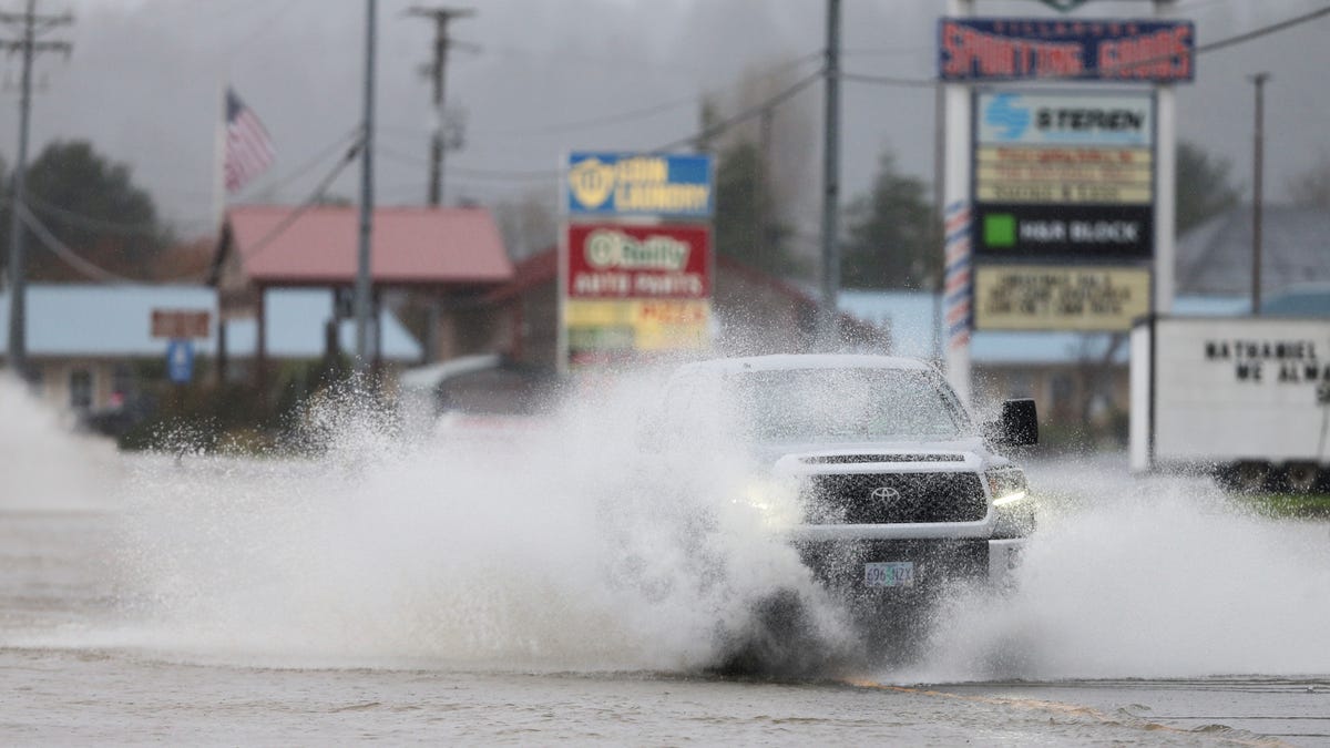
Heavy rain and flooding in the Pacific Northwest have caused two deaths in Oregon, with authorities suspecting drowning as the cause. The region has experienced landslides, road closures, and disrupted rail service due to the robust atmospheric river. Flood watches and warnings are in effect across Washington, Oregon, northern Idaho, and far northwest Montana. The heaviest rain is expected to shift to western portions of Oregon and eventually northern California, potentially causing flooding in poor drainage areas. Meanwhile, snow showers in the central Appalachians will end early Wednesday, and a warming trend with above-average temperatures is forecasted for the central US.
Heavy rainfall in Oregon has caused flooding along the coast and swollen creeks in Portland. The Wilson River near Tillamook has breached its dike, leading to rising water levels and potential damage to homes. Meteorologists predict continued rainfall, with 1 to 2 inches expected along the coast and up to 4 inches in higher terrains. Two deaths have been reported, and several flood advisories are in effect. Businesses and schools have closed, and residents are on alert for potential evacuations.
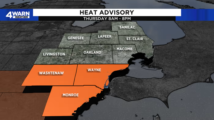
The National Weather Service has issued a heat advisory for several counties in Southeast Michigan, including Lenawee, Monroe, Washtenaw, and Wayne, from 8 a.m. to 8 p.m. on Thursday, August 24. Temperatures are expected to reach the lower 90s with high humidity levels, resulting in heat indices of 100-105. Residents are advised to stay hydrated, seek air-conditioned spaces, avoid direct sunlight, and check on vulnerable individuals.
A storm with heavy rains and strong winds left more than 125,000 people without power and caused flooding in some areas of Michigan. Wind gusts reached up to 67 mph in Romulus, and most of the electric outages occurred in Southeast Michigan. Some streets in the Ann Arbor area were temporarily flooded.
One person has died and around 15 others were injured after a likely tornado struck the city of La Chaux-de-Fonds in northwestern Switzerland. The storm caused significant damage, with vehicles destroyed, roofs torn off, and trees uprooted. Wind speeds of 217 kilometers per hour were recorded, and further storms are expected. Rescue and clean-up operations are underway, and people are urged to avoid going outside due to the risk of falling debris.
Hurricane Calvin has strengthened into a Category 3 storm in the Pacific Ocean, with wind speeds near 120 miles per hour, but is expected to weaken before reaching Hawaii next week. While it could strengthen further on Friday, it is forecasted to start weakening on Saturday. There are currently no coastal watches or warnings in effect. Hawaii occasionally experiences storms that form to the east, but it is unusual for a named storm to make landfall in the state. The last hurricane to hit Hawaii was Iniki in 1992. Climate change is increasing the likelihood of major hurricanes and affecting the amount of rainfall they produce.