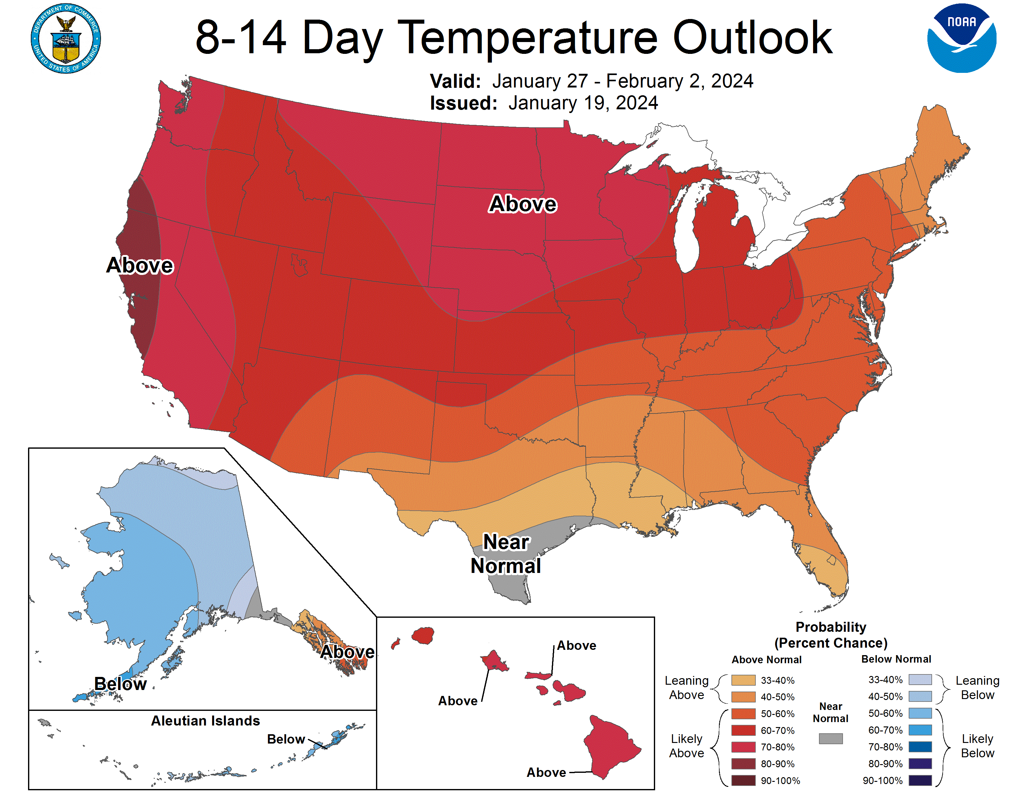
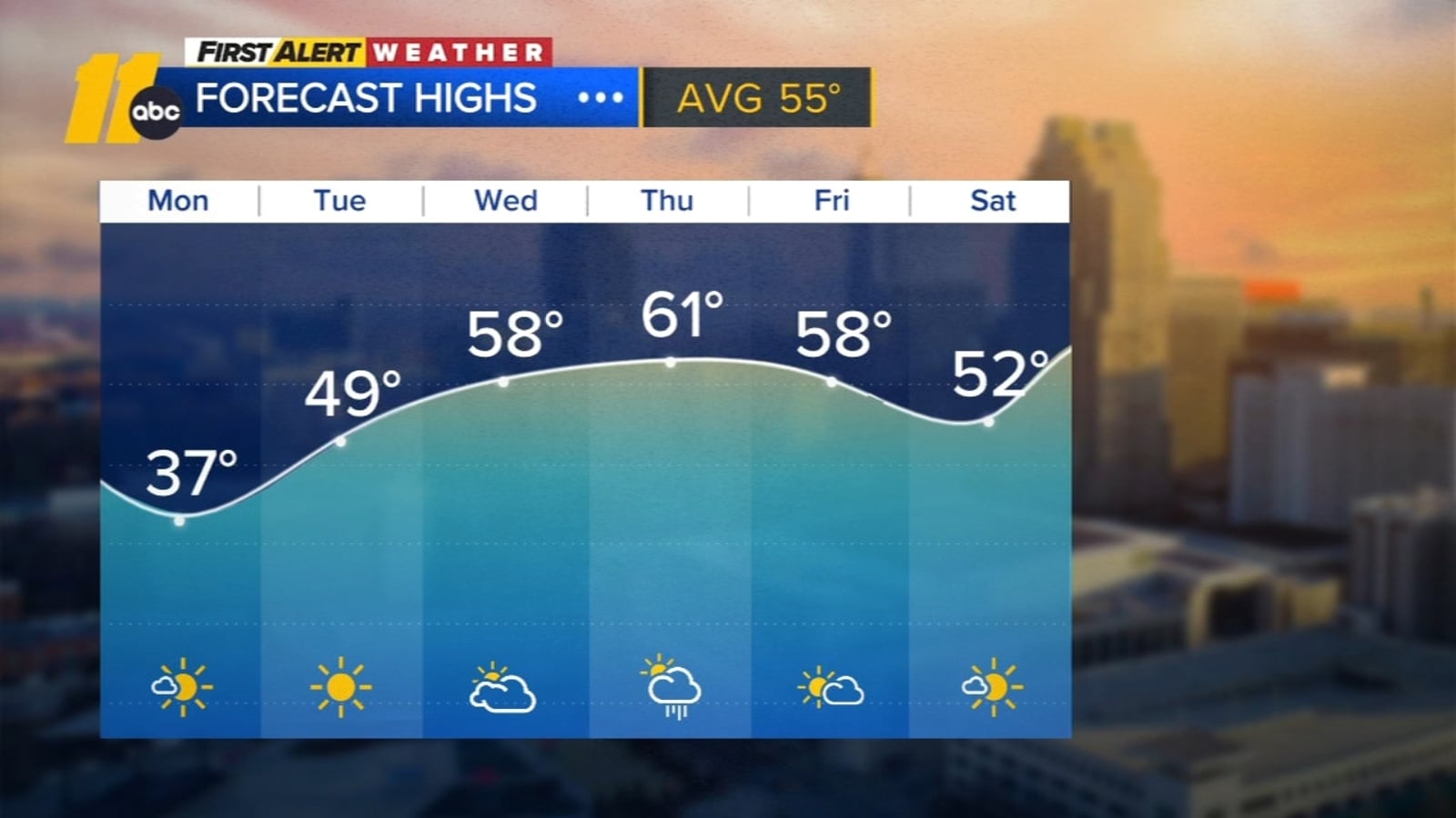
A cold snap with temperatures in the teens and wind chills of 5 to 10 degrees is affecting Central North Carolina, accompanied by gusty winds and a Cold Weather Advisory until Monday morning. Safety precautions are advised, but a warm-up is expected starting Tuesday, with temperatures rising into the mid-60s by Thursday.
Central New York has experienced an unusually hot and dry July, with temperatures frequently reaching 90 degrees and rainfall significantly below normal. Relief is expected later in the week as a cold front brings cooler temperatures around 80 degrees, but rainfall will likely be light and infrequent, leaving soil moisture low.
A moderate chance of warmer-than-normal temperatures is expected in Michigan from July to September 2025, with occasional hot spells and no significant prolonged heat wave, according to NOAA's latest forecast, alongside variable precipitation patterns across the region.
Minnesota experienced a rare and extreme weather event with a three-day snowstorm that dropped over 6 inches of snow across more than 60% of the state, along with an inch of rain in some areas, erasing precipitation deficits. This combination of heavy snow and rain is a rare meteorological feat, occurring only twice on record in the past 40 years. A winter weather advisory is in effect for northeastern Minnesota and northwestern Wisconsin, with warmer temperatures expected late next week, possibly reaching the 70s.
A mixed bag of precipitation is expected to cover most of Lower Michigan today, with freezing rain changing to rain in the southern third and mostly snow, mixed with sleet and occasional freezing rain, in the central third. Temperatures will slowly warm, reaching 33-34 degrees, causing slow melting of ice and snow. Freezing rain accumulation is forecasted to be light, with up to one-tenth of an inch, and snow accumulation is expected to be 1-3 inches. Travelers are advised to wait a couple of hours for improved road conditions, and a solid wet period is anticipated over the next few days.
Freezing rain is expected to move into central Arkansas tonight, with temperatures hovering around 32°F, potentially causing dangerous road conditions for the Monday morning commute. It is advised to stay off the roads until temperatures rise above freezing midmorning. Rain will persist throughout Monday and Tuesday, with temperatures in the 40s and 50s, eliminating the risk of winter weather. Another rainstorm is forecasted for Wednesday, with mild temperatures expected to continue through the week.
A supersized January thaw is expected to melt most of the snow cover across Minnesota by late next week, with temperatures reaching the 30s and possibly even the 40s or 50s in some spots by early February. The weekend will bring cold temperatures, but the milder Pacific air mass will lead to a significant warm-up, accompanied by sunshine, and an increase in daylight as Minnesota moves past the darkest months of winter. However, historical patterns of snow and subzero cold in February may not hold true this year.
A significant shift in the upper-air pattern over the northern hemisphere is expected to bring much warmer temperatures lasting at least a week, with forecasts showing temperatures 10 to 20 degrees above normal for much of the U.S., including Michigan, into early February. While a return to colder weather may occur in February, the prolonged warmth raises the possibility of an early end to the winter season.
The latest seasonal outlook from NOAA suggests that many states, including Colorado, could experience warmer weather between February and April, with the northern half of the country leaning towards above-average temperatures. The Pacific Northwest has the highest chance of a warm late winter and early spring, while Texas, especially West Texas, is predicted to see below-average temperatures. The precipitation forecast indicates that the impact of El Niño is expected to continue, with the Pacific Northwest and Ohio Valley likely to see less rain and snow, while Southern states are expected to experience a wet winter continuing into spring. NOAA also expects El Niño to phase out between April and June.
Michigan is set to experience a dramatic shift in weather next week, with above-normal temperatures and precipitation expected to melt the recent snowfall. The National Weather Service forecasts a significant warm-up, potentially leading to a reduction in snow accumulation and a risk of local river and stream flooding. Currently, the region is experiencing an Arctic air mass, but this is expected to be replaced by warmer and drier conditions after the weekend.
The chances of having a White Christmas this year are slim, as the temperature forecast for Michigan and the Great Lakes region shows an 80-90% chance of warmer-than-normal temperatures. The rest of the US, except for southern Florida, also expects warmer weather. Additionally, the precipitation forecast indicates drier-than-normal conditions, making it unlikely for a significant amount of snow to accumulate. Only the Upper Peninsula and parts of northeast Lower Michigan may have a trace of snow on Christmas morning, while the rest of the region is likely to have a brown and warm Christmas. This is attributed to the influence of El Niño.
Michigan will experience cooler temperatures this weekend, with mornings dropping several degrees below freezing and afternoons being cool by mid-November standards. There won't be any storm systems, so the state should remain dry. Winds will be relatively calm, with a stiff breeze on Saturday and lighter winds on Sunday. However, a major weather pattern change is expected next Wednesday, so it's advised to prepare for winter.
After a warm week, a cold front is expected to bring a brief cooldown, but a long stretch of cold weather is unlikely. The upper-level air flow and temperature deviation from normal indicate a return to mild temperatures by mid-October, with afternoons in the 60s and low-70s. The fall color change will be accelerated by the upcoming chilly spell, but overall, late October is expected to be mild with temperatures slightly warmer than normal.
Arizona is set to experience another hot day, with Phoenix expecting a temperature of 108 degrees and an excessive heat warning in effect until 8 p.m. Sunday. However, temperatures are predicted to gradually cool off throughout the week, with highs dropping to 100 degrees by Friday. Flagstaff will also see a hot day with a high near 82 degrees, but temperatures will start to return to normal later in the week, accompanied by chances of rain. Tucson is under an excessive heat warning with a high of 108 degrees, but temperatures are expected to cool down midweek, reaching a high near 98 degrees on Thursday and Friday.
The San Francisco Bay Area is experiencing a troughy weather pattern with low pressure systems bringing cooler temperatures and cloudy conditions. The pattern is expected to persist through Memorial Day weekend and into early June, with afternoon highs 5 to 15 degrees below normal. A weak ridge of high pressure may bring lighter clouds on Saturday, but another trough of low pressure moves in on Sunday. The maximum forecast temperatures for key cities around the Bay Area are not expected to break out of the 60s. There is no sign of a strong ridge of high pressure in the forecast, and the gloomy weather pattern is unlikely to end anytime soon.