Tag

January Thaw

All articles tagged with #january thaw

weather1 year ago

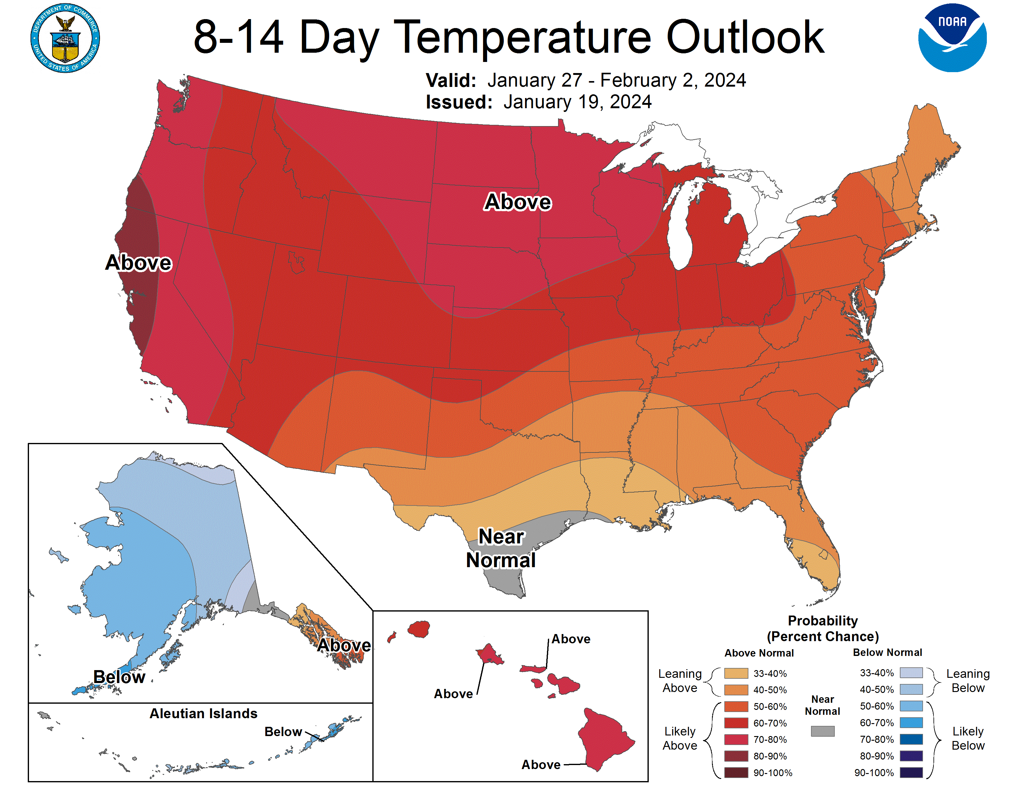
"Record January Thaw Ends with Snowfall and Winter Weather Advisory in Minnesota"

Minnesota is experiencing its longest January thaw on record, with the Twin Cities seeing 24 consecutive days above freezing. St. Cloud also observed its longest January Thaw on record, spanning 17 days. Despite the thaw, snow is expected to arrive Wednesday, with the Twin Cities potentially receiving 1-2 inches and southern areas possibly seeing heavier totals.

weather2 years ago

"Extended January Thaw: Anticipating a Significant Winter Heat Wave"

Minneapolis and much of southern Minnesota are experiencing one of the longest January thaws on record, with temperatures expected to remain above freezing for at least 10 days. This phenomenon, occurring 94% of the time in the Twin Cities, brings a brief respite to the typically freezing January weather. The upper air pattern shift from northwest Arctic flow to westerly Pacific airflow triggers the January thaw, and despite overall warming trends, the frequency and duration of these events have remained largely unchanged. Forecast models indicate mild temperatures well into next week, with the possibility of 40s and 50s in the region.

weather2 years ago

"From Historic Freeze to Supersized Thaw: US Weather Set for Wild Temperature Swing"

A supersized January thaw is expected to melt most of the snow cover across Minnesota by late next week, with temperatures reaching the 30s and possibly even the 40s or 50s in some spots by early February. The weekend will bring cold temperatures, but the milder Pacific air mass will lead to a significant warm-up, accompanied by sunshine, and an increase in daylight as Minnesota moves past the darkest months of winter. However, historical patterns of snow and subzero cold in February may not hold true this year.

weather2 years ago

"Temperature Rollercoaster: From Bitter Cold to Thaw and Flooding Risk in US"

A January thaw is expected to bring a mix of ice, snow, heavy rain, and fog to central and eastern US next week, leading to travel disruptions and flooding risk. Temperatures will rise substantially, causing moisture to encounter cold ground, potentially leading to ice formation and hazardous conditions on roads and sidewalks. Areas from the southern Plains to the Northeast may experience wintry precipitation, while fog and low clouds could impact travel in the mid-Atlantic and Southeast. The upcoming thaw may also cause some ice to break up in the Midwest and Northeast, with a low risk of ice jams.

weather2 years ago

"Anticipating a January Thaw: Weather Shifts from Freezing to Warmer Temperatures"

Another blast of arctic air will chill the South and East through Saturday, followed by a January thaw next week that could last until the end of the month, bringing relief to areas hit by recent winter storms and cold air outbreaks. The thaw will be accompanied by milder air, rain, and potential flooding, as a reversal of the weather pattern that caused the cold air and winter storms is expected.

weather2 years ago

"From Cold to Comfort: Next Week's Big Warm Up"

Meteorologists are predicting a significant warmup across nearly 90% of the United States by the middle of next week, with temperatures expected to be 8-14 degrees above normal in the Plains and Midwest. This "dramatic" January thaw is attributed to a high-pressure area off the East Coast that will bring milder air originating primarily over the waters south of the nation. However, before the warmer air arrives, a new surge of colder air is forecast for this week. The January thaw typically lasts for about a week and is expected to bring above-normal temperatures for at least the next 10 days across the entire Lower 48.