A strong weather system is bringing howling winds, dropping temperatures, and a high wind warning to Maryland, with gusts up to 70 MPH in mountain areas, causing potential tree damage and power outages, and continuing cold and breezy conditions through New Year's.
A strong cold front is bringing howling winds, dropping temperatures into the 30s and 20s, with gusts exceeding 70 MPH in Maryland, leading to a high wind warning, scattered power outages, and a cold, windy start to the new year.
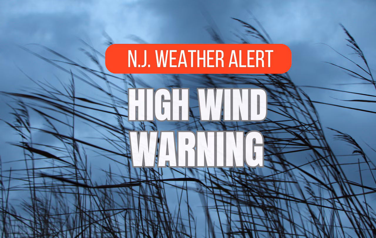
A powerful nor’easter is expected to hit New Jersey with wind gusts up to 60 mph, heavy rain, and coastal flooding, prompting high wind warnings and a state of emergency across all 21 counties, with potential for widespread power outages and difficult travel conditions.
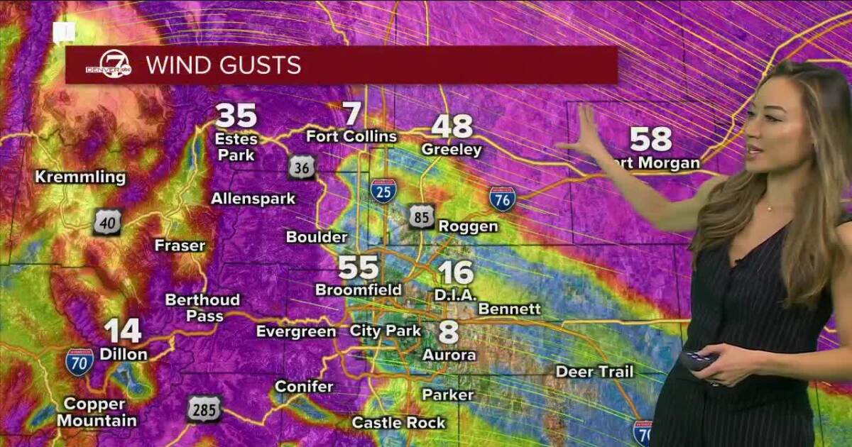
The high wind warning has expired for Denver and metro communities, but extreme gusts are still possible in Colorado, with winds reaching 30 to 40 mph and gusts up to 70 mph. Downed trees and power lines remain a concern, and critical fire danger conditions exist. Some areas are under red flag warnings, and the highest winds reported over the weekend have reached up to 91 mph in various counties. A gradual warm-up is expected in the metro this week.
The Los Angeles Zoo is closed to the public due to powerful Santa Ana winds sweeping across the region, causing damage and impacting normal operations. Many areas in Southern California experienced downed trees and power lines due to the high winds.
The National Weather Service has lifted the lake effect snow warning for Central New York as the two-day storm comes to an end, with scattered snow showers expected to continue but minimal travel impacts. A narrow band of lake effect snow brought over a foot of snow to some areas in Madison and Oneida counties, with winds of 15 mph or more potentially blowing snow around through midnight. Official snowfall totals will be compiled later, and a high wind warning has also ended.
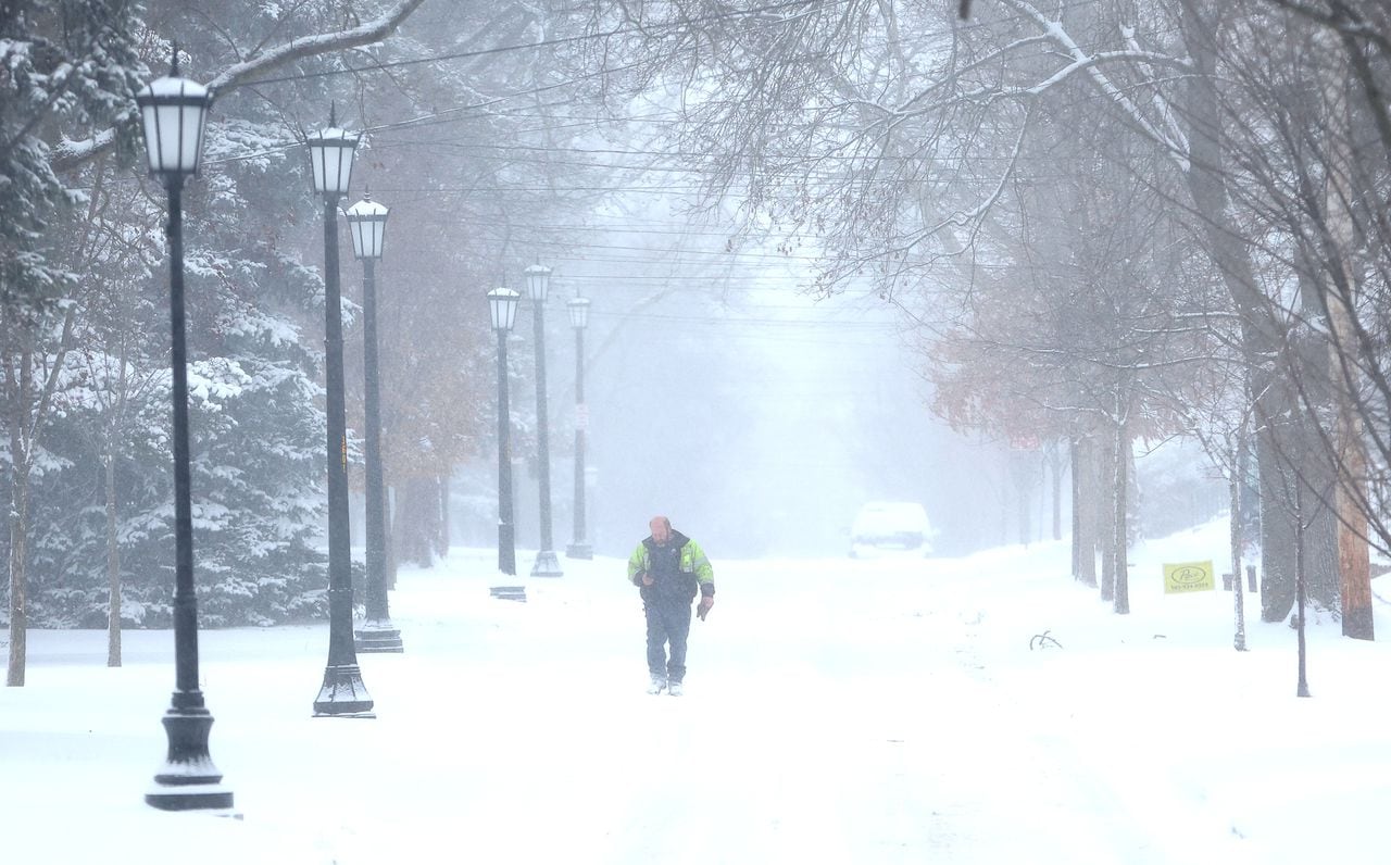
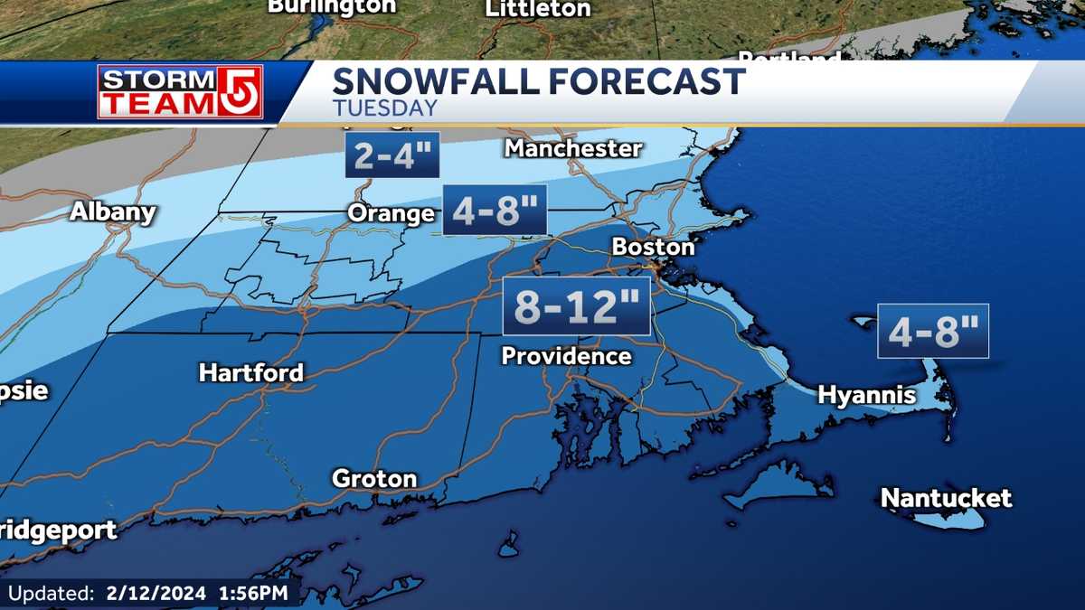
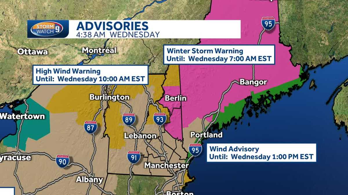
A nor'easter is expected to bring up to a foot of snow to parts of Massachusetts on Tuesday, along with strong winds, leading to a risk of power outages and hazardous travel. Winter storm warnings and high wind warnings have been issued for various parts of the state, with the storm peaking between 8 a.m. and 2 p.m. Coastal flooding and beach erosion are likely, especially during high tide, and wind gusts of over 40 mph are expected. The storm follows record-high temperatures just days before, and Tuesday night will turn drier as the storm moves out, with colder temperatures expected for Valentine's Day and beyond.
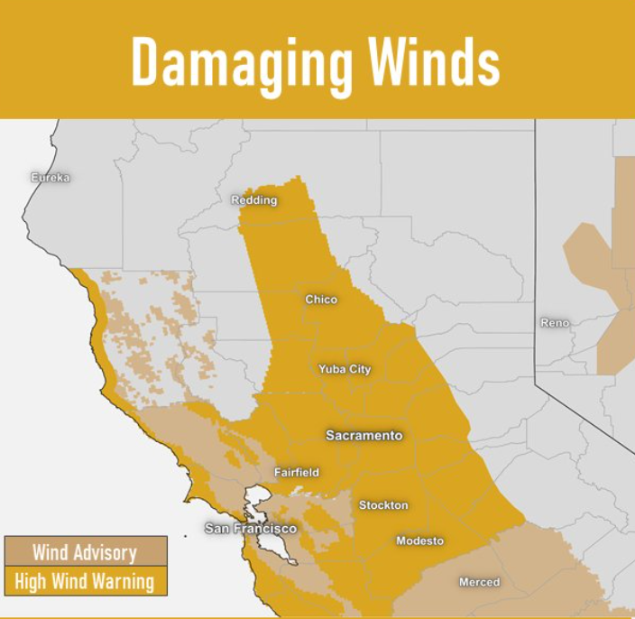
A "severe" high wind warning is in effect across most of Northern California, including the Sacramento Valley, Northern San Joaquin Valley, and Northeast Foothills, with wind speeds expected to range between 25 to 45 miles per hour and gusts between 50 to 70 mph. The National Weather Service advises people to take precautions, as the strong winds could cause damage to trees and power lines, leading to widespread power outages. Additionally, a winter storm warning is in effect for the Sierra region, with significant snowfall expected and travel conditions anticipated to be difficult.
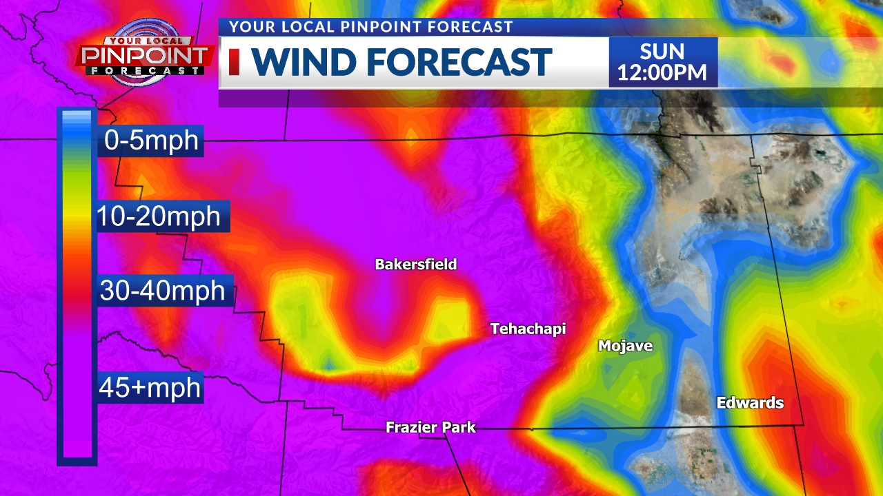
Kern County is expected to experience extreme wind gusts reaching 55 to 60 mph late tonight into Sunday, with a High Wind Warning issued for the Bakersfield area. The strong winds may uproot trees due to the recent heavy rains, and heavy rains are expected to follow on Sunday, with valley areas expecting 1-1.50 inches of rain and mountain areas picking up near 2 inches.
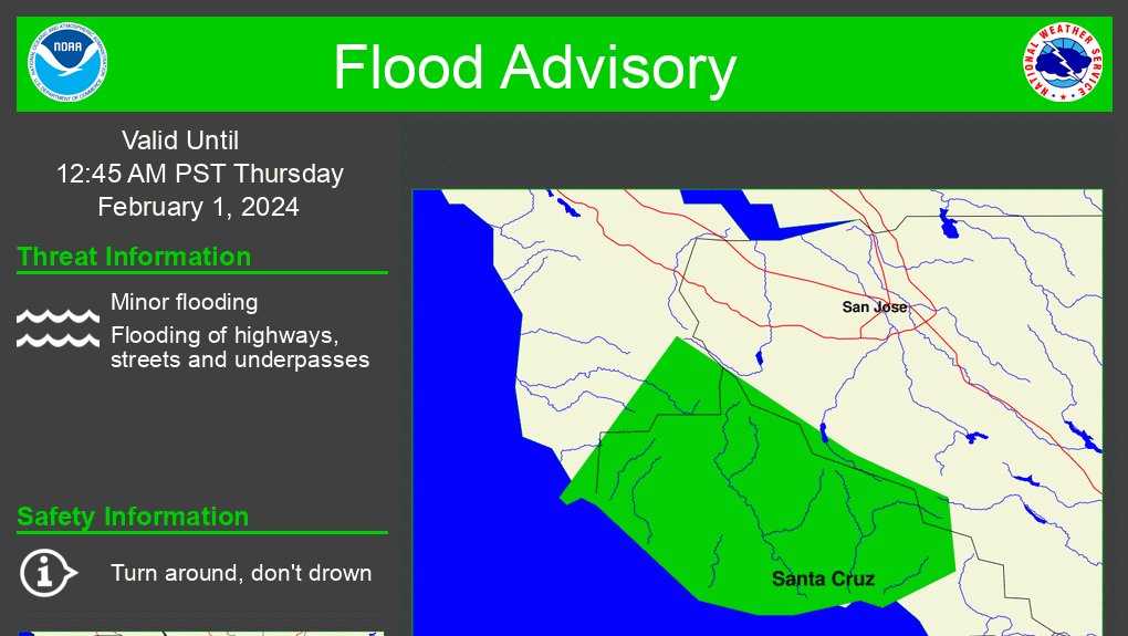
Severe weather is expected along the Central Coast with a flood advisory issued for Santa Cruz County and the Big Sur area, as well as power outages affecting PG&E customers east of Salinas. The National Weather Service has also issued a high wind warning for much of the coastline and mountains, with potential power outages, especially in the mountains and Monterey Peninsula through 2 a.m.
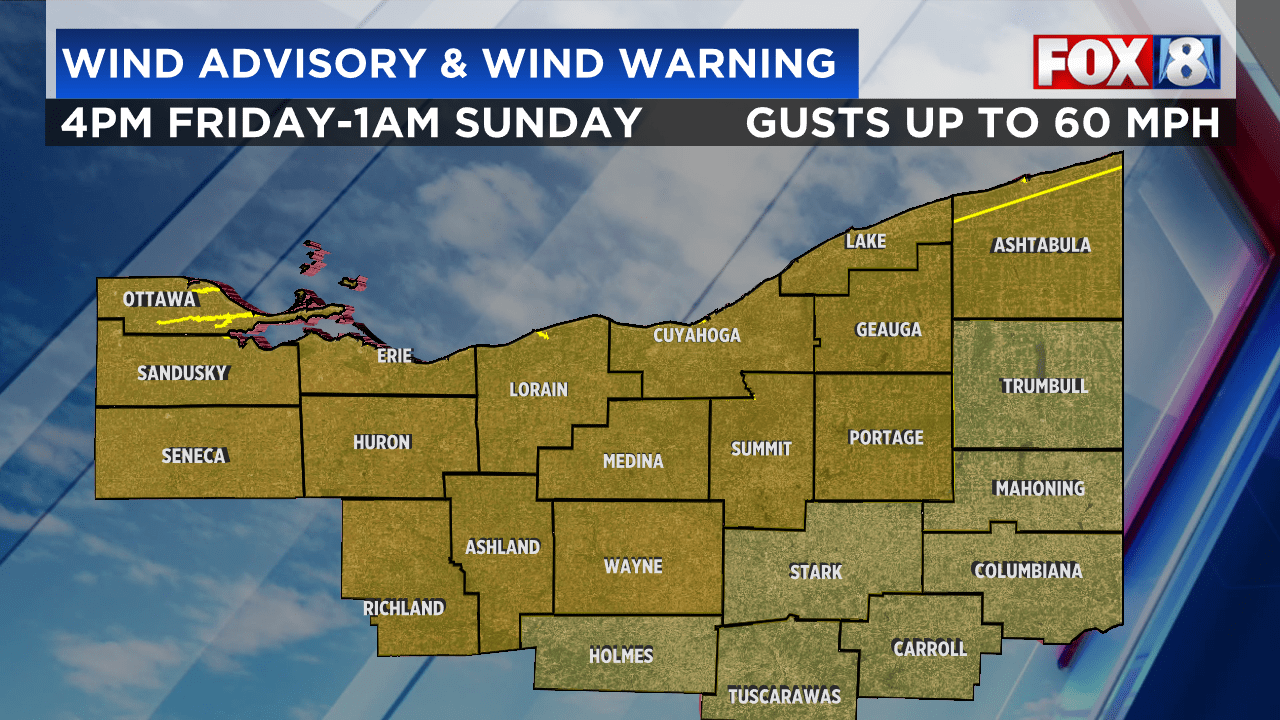
Northeast Ohio is bracing for blustery winds, bitter cold temperatures, and low visibility conditions this weekend, with a High Wind Warning and Wind Advisory issued for several counties. Expect wind gusts exceeding 40 mph, light to moderate snow showers on Saturday, and subzero wind chills with temperatures in the teens for several days. Bundle up and stay updated with the latest forecast.
A flood warning is in effect for parts of New Hampshire as a storm passes through, bringing heavy rain and gusty winds. The flood warning is in place for southeastern NH until 10am due to 1-2+" of rain coupled with snow melt-off, making for a messy morning commute. A high wind warning remains in effect for the coast and White Mountains, with winds gusting to 55 mph. The heavy wet snow up north will wind down after sunrise, with some spots seeing over 6" of snow. The weather is expected to quiet down by Thursday and Friday before another storm system arrives for the holiday weekend.
Watertown International Airport recorded the north country’s strongest wind gust at 78 miles per hour, with gusts of 70 miles per hour reported in Belleville and 63 miles per hour in Harrisburg. The National Weather Service forecasts gusts of 60 to 70 miles per hour until midnight, with Jefferson and Lewis Counties under a high wind warning.
The New York City Emergency Management Department has updated its travel advisory for a strong winter storm, with a citywide high wind warning in effect from 6:00 p.m. today to 6:00 a.m. Wednesday, expecting gusts up to 70 mph and widespread power outages. Additionally, a flood watch, coastal flood warning, and advisory are in effect, with potential for significant coastal flooding and heavy rainfall. Mayor Eric Adams and NYC Emergency Management Commissioner Zach Iscol urge New Yorkers to take necessary precautions, while various city departments are prepared to respond to the storm's effects. Residents are encouraged to stay informed, use public transportation, clear debris from catch basins, check on vulnerable individuals, and report any emergencies.
The DC area is bracing for heavy downpours and potentially dangerous winds of up to 60 mph during the Tuesday afternoon commute, with a high wind warning in effect and a flood watch in place. Coastal flooding is also a concern, and preparations for the storm are underway, including school closures and distribution of free sandbags. Drivers are advised to plan ahead for slick roads and potential power outages, while residents are urged to secure loose outdoor items.