Alabama Braces for Ice, Snow, and Severe Storms This Weekend
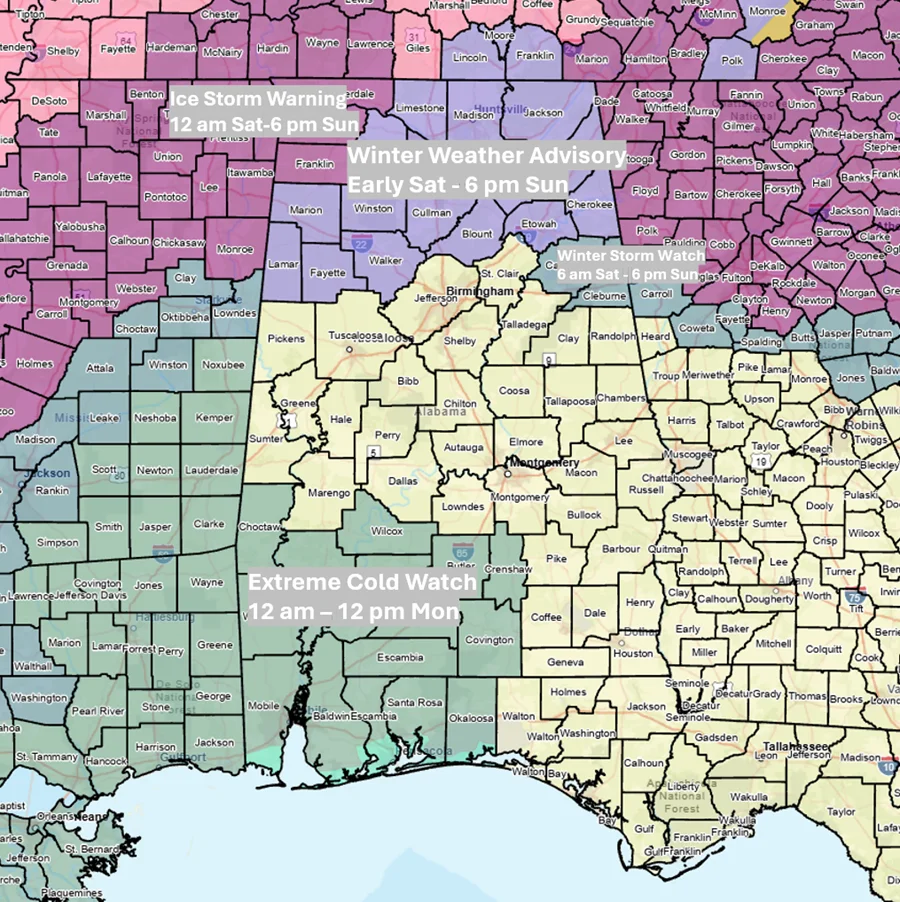
Alabama faces a multi‑part winter storm this weekend, with ice-storm warnings in Lauderdale, Colbert and Franklin counties, winter weather advisories and a watch near I-20. Precipitation arrives Saturday, bringing 2‑4 inches of liquid‑equivalent precipitation (higher in the north) and up to about 1 inch of freezing rain in the far north, while the southern half could see 1‑3 inches of rain. Freezing rain may mix with sleet north of I‑20 early, and snow is possible in the far northwest (up to about 1 inch) Sunday afternoon. A line of showers and thunderstorms with 40–60 mph gusts and a tornado risk could affect the southern half Sunday. Very cold air follows, with teens north to 20s elsewhere Monday, wind chills potentially as low as -3 in the north, and highs in the 20s–40s; Tuesday brings single digits north to teens south. Roadways could develop icy spots from any standing water.
- Severe Winter Weather Alerts: Ice and Snow Expected in Alabama ema.alabama.gov
- First Alert Weather Day: Freezing rain, ice accumulation possible wbrc.com
- First Alert: Storm threat Sunday ahead of bitter cold next week wsfa.com
- James Spann: Ice storm warning issued for northwest Alabama this weekend alabamanewscenter.com
- Timeline for snow, ice in north Alabama: When will freezing rain, sleet and dangerous cold arrive? al.com
Reading Insights
0
12
2 min
vs 3 min read
70%
499 → 149 words
Want the full story? Read the original article
Read on ema.alabama.gov