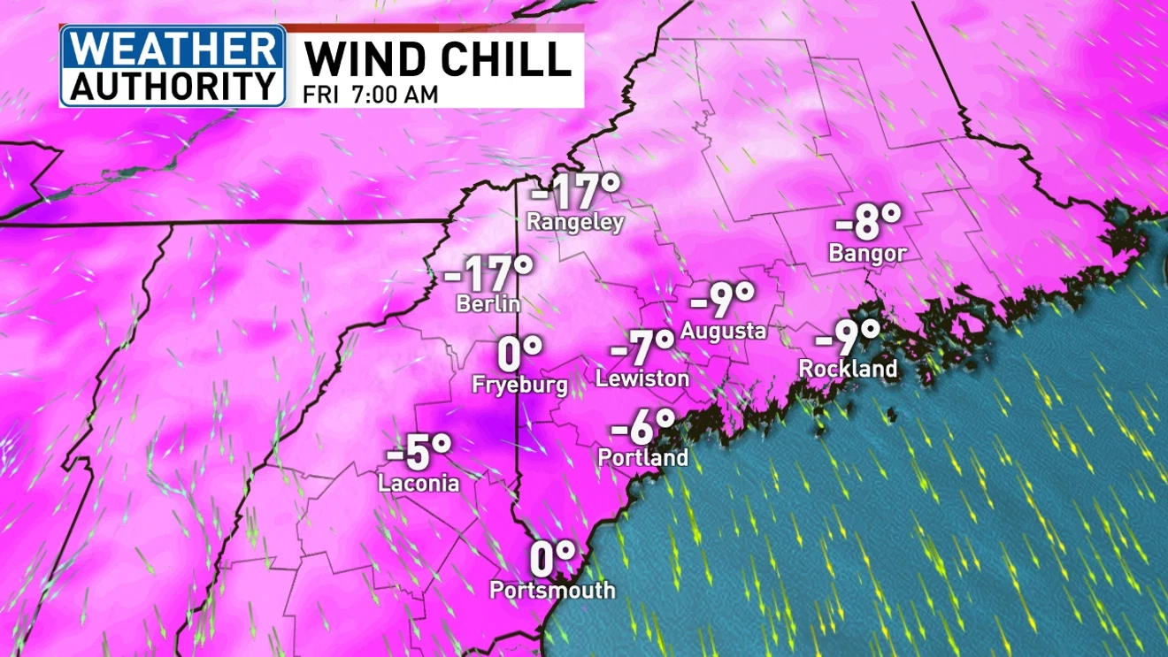
Maine is experiencing a cold Friday with wind chills in the negatives, followed by a quiet weekend with temperatures in the teens and low 30s, and a potential mixed precipitation event early next week, including snow and rain.
A cold snap with temperatures in the teens and wind chills of 5 to 10 degrees is affecting Central North Carolina, accompanied by gusty winds and a Cold Weather Advisory until Monday morning. Safety precautions are advised, but a warm-up is expected starting Tuesday, with temperatures rising into the mid-60s by Thursday.
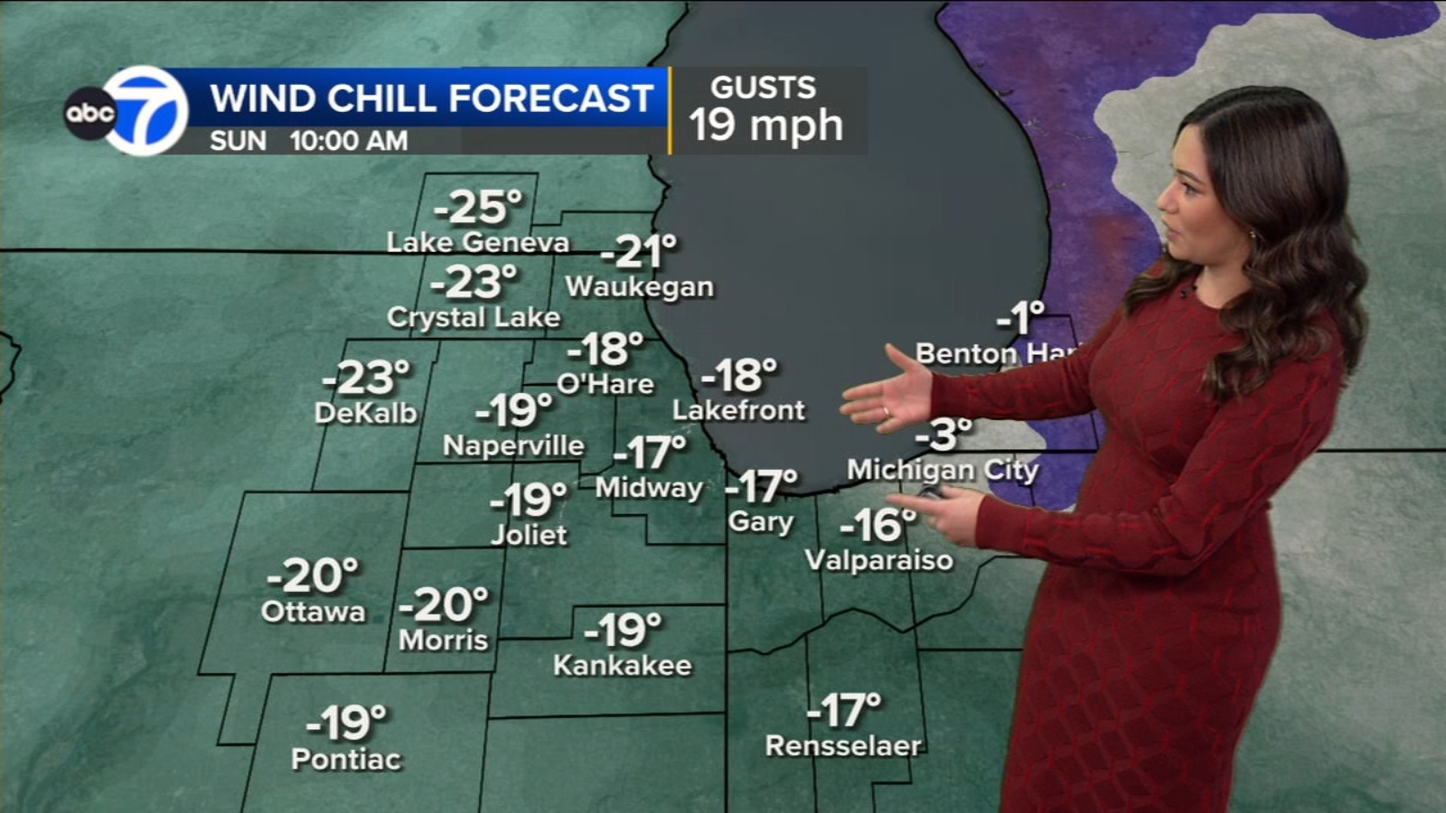
An arctic blast is causing dangerous sub-zero wind chills in the Chicago area, with wind chills dropping to -20 to -25°F, prompting weather advisories and warming centers, but a warming trend is expected next week.
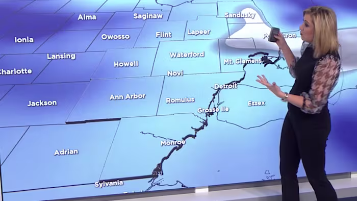
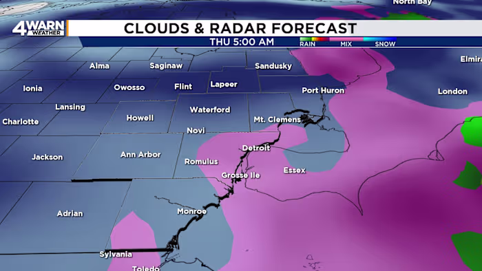
Metro Detroit is expected to experience up to 3 inches of snow this week, with heavier snowfall and snow squalls possible due to lake-effect snow. A 4Warn Weather Alert has been issued for Wednesday evening into Thursday morning, with gusty winds up to 40 mph and wind chills dropping below zero. The snow is expected to start Wednesday morning, intensify in the evening, and potentially affect the Thursday morning commute. Power outages are possible due to high winds, and temperatures will remain frigid through Friday morning.
A winter storm is expected to bring snow to Southeast Michigan over the next 48 hours, with the heaviest snowfall likely occurring from Wednesday night into Thursday morning. Snow flurries may begin early Wednesday, with light accumulation possible in the Thumb region. Snow chances increase Wednesday afternoon, potentially mixing with rain, leading to a wet snow event. The heaviest snow is expected overnight Wednesday into Thursday, with 1-2 inches of accumulation and strong winds causing blowing snow and reduced visibility. Temperatures will feel significantly colder due to wind chills.
A cold front has brought the coldest weather of the season to the area, with temperatures expected to drop into the 20s tonight, marking the first official freeze. Saturday will see temperatures barely rising above freezing, with wind chills making it feel even colder.
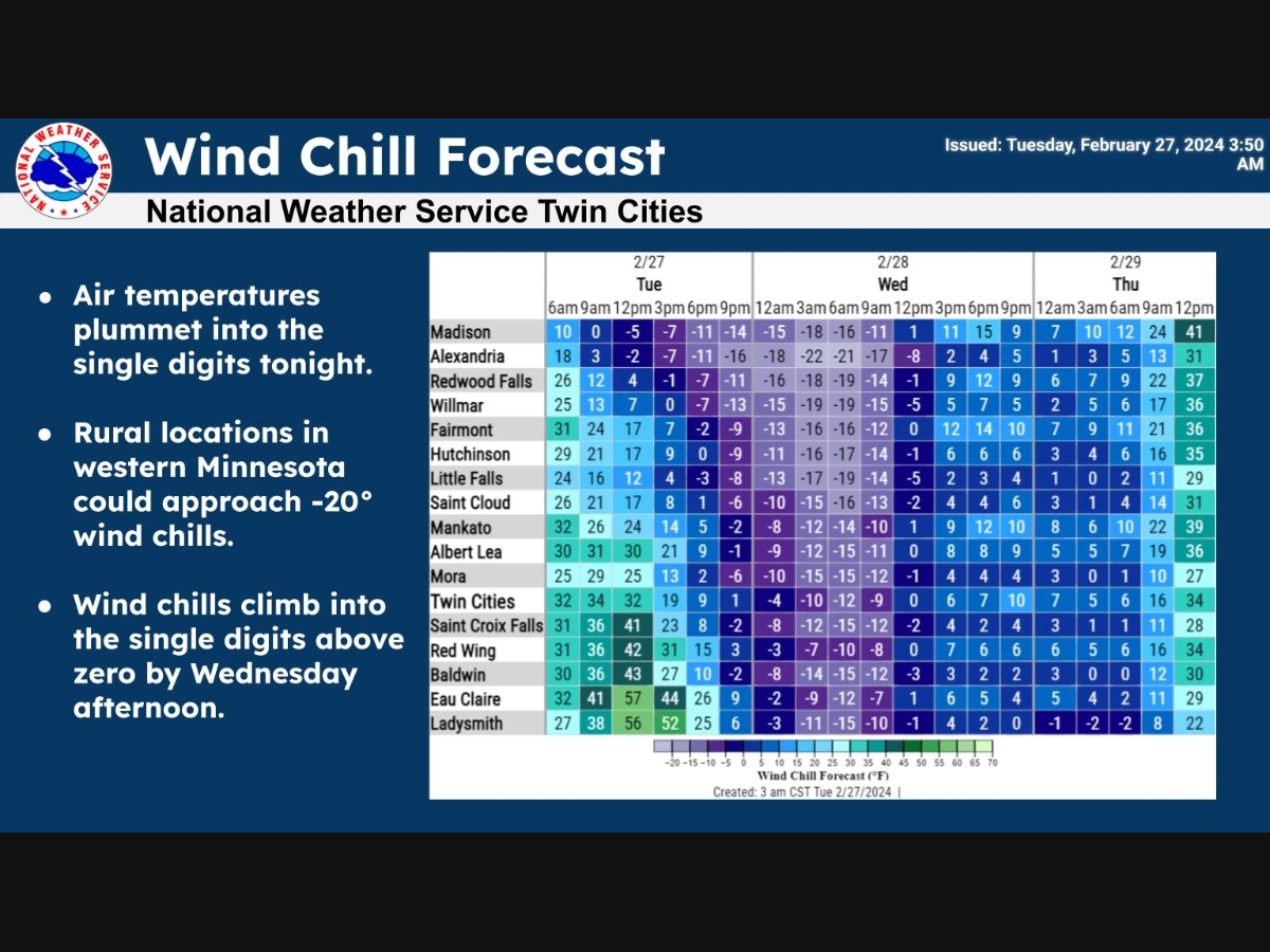
After experiencing highs in the 60s, Minnesota is bracing for a drastic weather change with the arrival of snow and plummeting temperatures, leading to wind chills as low as -20 degrees overnight. The National Weather Service has issued forecasts for potential snow and blustery conditions, with temperatures expected to drop significantly before gradually rising again later in the week.
Blustery conditions and low clouds are decreasing into sunset, with wind chills as low as zero degrees possible tonight and continued cold and blustery conditions expected for Sunday. Temperatures will bottom out in the teens tonight, with wind gusts easing toward 20 mph by dawn. Sunday will be mainly sunny with early wind chills around zero, slowly warming above 20 degrees late day. Snow lovers are looking ahead to Presidents’ Day, as a warmer temperature trend is expected over the next 10 days, but confidence is low.
Brutal cold, harsh wind chills, and persistent lake effect snow are expected this weekend, leading to difficult travel conditions. Weather alerts are in effect due to cold air crossing Lake Ontario, bringing concerns about significant snow accumulation. The lake effect snow is expected to continue through Sunday morning, with above-average temperatures predicted for later next week.
Snow showers are expected to continue into the evening, adding to the existing snowpack, with very cold conditions and wicked wind chills expected tonight through Saturday. Saturday will be bright but cold with highs in the mid-20s and gusts of 30 to 35 mph, leading to wind chills in the single digits to around 10 degrees. Sunday will be sun-filled but still chilly, with highs in the upper 20s and lower 30s and gusty winds continuing.
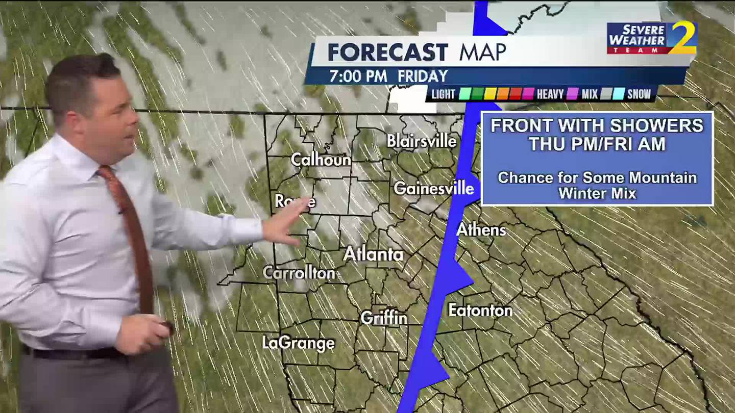
North Georgia is preparing for a bitterly cold weekend as an arctic blast brings dangerously low temperatures and wind chills near zero on Saturday morning, with high temperatures staying below freezing. Residents are advised to take precautions as the region braces for the cold snap before a shift to rainy and warmer weather early next week.
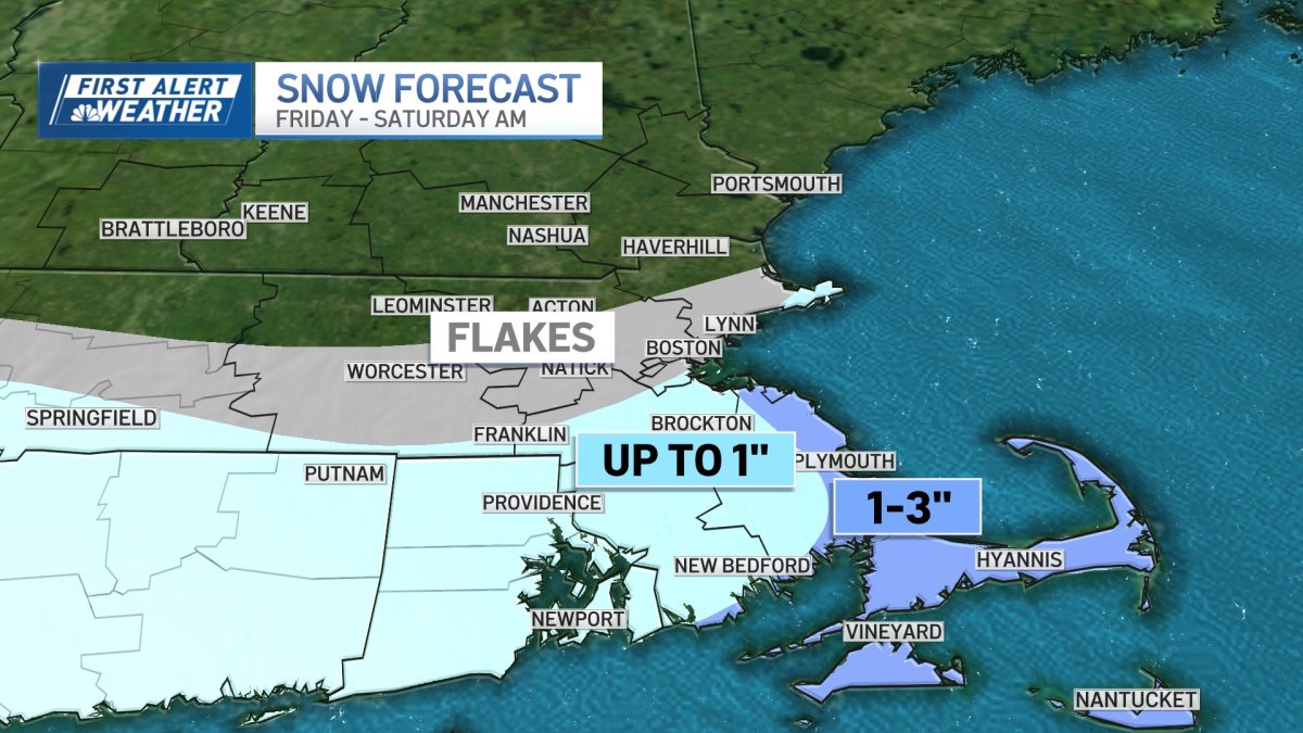
A storm system moving south of the islands will bring ocean effect snow to coastal communities on the South Shore of Massachusetts on Friday, with 1 to 3 inches expected in some spots. Cold winds will result in wind chills near or below zero, with gusts up to 35 mph on Saturday night. A slight warmup is anticipated next week, but reinforcing shots of cold air could bring mixed precipitation and keep temperatures in the 30s.
Many schools and businesses in the Greater Cincinnati area are closed or delayed on Friday due to anticipated winter weather, with Cincinnati Public Schools among those closed. A Winter Weather Advisory is in effect until 1 a.m. Saturday, with 1-3 inches of snow expected for most areas and some isolated amounts up to 4 inches. Temperatures will fall through the 20s into the teens by evening, leading to potential road impacts lingering through Friday night. Wind chills will be in the single digits, and by Saturday morning, they will be near advisory levels between -5 and -10 below. Highs on Saturday will be in the mid-teens under cloudy skies, with temperatures gradually warming up starting Monday.
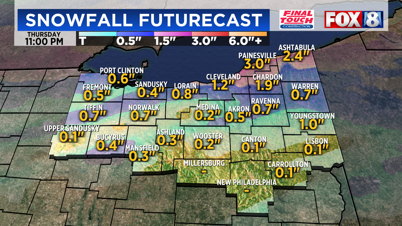
A Winter Storm Watch will be in effect in several Northeast Ohio counties starting at 1 a.m. Friday, with gusty winds and temperatures around 20 degrees leading to single-digit wind chills. Snow showers are expected on Thursday, potentially causing a slippery morning commute with 1-3 inches possible in northern communities and a dusting to 1 inch for most areas. More widespread snow showers are forecast for Friday, with the possibility of several inches accumulating by the weekend. Cold weather is expected to persist until early next week, with highs in the 30s and 40s.
The Tri-State area is bracing for another round of snow and bitterly cold wind chills, with forecasts predicting 1 to 2 inches of snow in Hagerstown, Martinsburg, and Greencastle on Friday, possibly reaching 4 inches south of the Maryland-Pennsylvania line. The dry, powdery snow could lead to concerns of melting and refreezing on roads, with low wind chills expected over the weekend, potentially feeling like 0 to 5 degrees during the day on Saturday and near zero at night. Sunday is forecast to be slightly better, with temperatures expected to rise above freezing on Monday.