The Farmers' Almanac, a 208-year-old publication known for long-range weather predictions and gardening tips, will cease publication after its 2026 edition due to financial challenges, marking the end of an era for its readers.
The Farmers' Almanac, a 208-year-old publication known for weather forecasts and gardening tips, announced that its 2026 edition will be its last due to financial challenges, with online access ending next month, marking the end of a long-standing tradition.
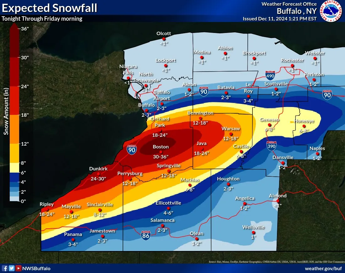
A significant lake effect snow event is expected to impact Buffalo and Western New York from late Wednesday through Friday, with heavy snow accumulations and strong winds causing difficult travel conditions. The National Weather Service has issued a Lake Effect Snow Warning for several counties, predicting 2 to 3 feet of snow in the most persistent bands, particularly in Southern Erie County. The snow will vary greatly across the region, with South Buffalo potentially seeing significant accumulation while North Buffalo may see little to none.
A Winter Storm Warning has been issued for Ottawa, Allegan, and Van Buren counties in Michigan, with heavy lake-effect snow expected overnight into Monday. This could lead to school closings in areas like Hudsonville, Zeeland, and Holland, with a moderate to high chance of closures in southern Ottawa and western Allegan counties. Grand Rapids is unlikely to see significant snow, while Kalamazoo may experience some impact depending on snowband development. The snowfall on Monday will influence potential school closings on Tuesday.
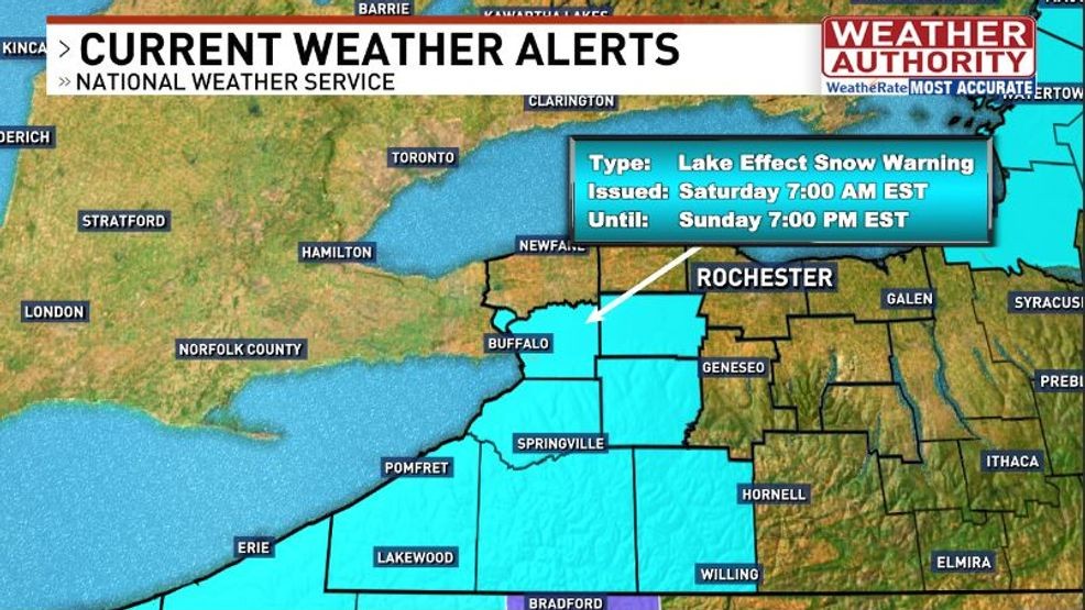
Lake effect snow is expected to impact areas south of Buffalo and north of Syracuse over the weekend, with significant travel disruptions anticipated. Snow accumulations of 3 to 6 inches are forecasted for southern Wyoming County, while Genesee County is under a lake effect snow warning until Monday. Those attending the Buffalo Bills game in Orchard Park should prepare for challenging travel conditions and cold temperatures. Below-average temperatures are expected to persist into next week, with another potential snow event mid-week.
The first snow of the season is expected on Saturday, with the KOMU 8 First Alert Weather Team placing the Storm Mode Index at 2 out of 5 due to potential travel disruptions. Snow will start in the morning, becoming widespread after daybreak and exiting by afternoon, with most areas seeing 2-4 inches. A Winter Weather Advisory is in effect from 6am to 6pm, particularly along and north of I-70, where heavier snow bands may develop. Cold conditions are expected for the Mizzou gameday, with temperatures in the 30s and wind chills in the 20s. A warming trend is anticipated early next week.
Thanksgiving travel is challenging due to a mix of rain and snow, with slippery roads in many valley areas and significant snow accumulation in the mountains, particularly the southern Adirondacks. A Winter Storm Warning is in effect for the most affected areas, while a Winter Weather Advisory covers regions with less severe impacts. Conditions are expected to improve over the weekend, though some areas may experience lake effect snow showers.
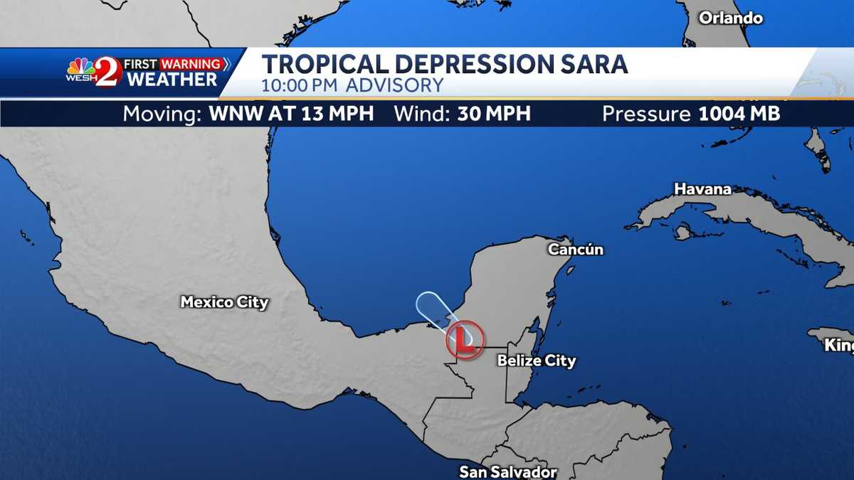
Tropical Depression Sara has formed in the Caribbean, and the National Hurricane Center is closely monitoring its path. Residents are advised to stay updated with the latest maps and models, as well as weather alerts from WESH 2 News for accurate forecasts in Central Florida. November hurricanes in Florida are rare, and the First Warning Weather team is providing continuous coverage.
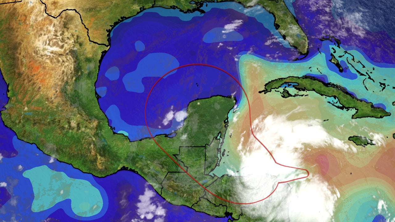
Tropical Storm Sara has stalled near Honduras and is expected to weaken and dissipate as it moves across Mexico's Yucatan Peninsula this weekend, posing no threat to Florida or the U.S. coast.
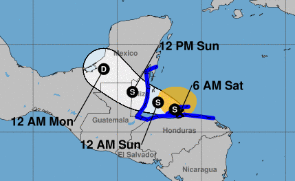
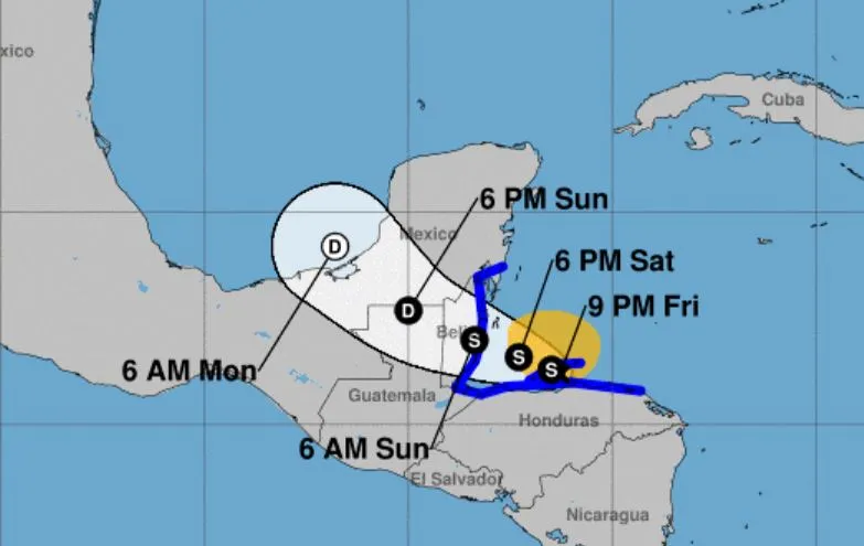
Tropical Storm Sara has stalled near Honduras and is expected to weaken and dissipate as it moves across Mexico's Yucatan Peninsula, posing no threat to Florida or the U.S. coast.
Tropical Storm Sara has become less organized as it moves over Nicaragua and Honduras, heading towards the Yucatan Peninsula. The NBC2 First Alert Hurricane Tracking team is closely monitoring the storm's progress as it moves north towards the Gulf of Mexico. For the latest updates, including maps, models, and forecast cones, visit NBC2's website.
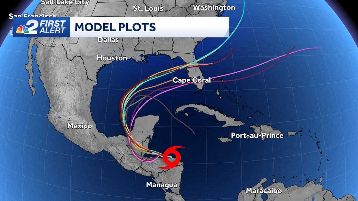
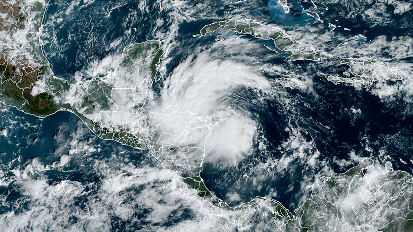
Tropical Storm Sara has formed over the western Caribbean Sea and is expected to bring potentially catastrophic flooding to Central America, including Honduras, Belize, El Salvador, and Guatemala, with up to 30 inches of rain possible. The storm is moving slowly due to high pressure and weak steering currents, which could lead to prolonged flooding. While the storm may enter the Gulf of Mexico, its impact on the U.S. remains uncertain. The hurricane season, which ends on November 30, has been hyperactive, with Sara contributing to high accumulated cyclone energy levels.
Tropical Storm Sara has formed in the Caribbean and is projected to move over the Yucatán Peninsula into the Gulf of Mexico, posing risks of dangerous flooding and mudslides in Central America. The storm's path and intensity are being closely monitored, with forecasts indicating potential impacts beyond its projected path. The National Hurricane Center provides updates on Sara's movement, including satellite imagery and forecast models.
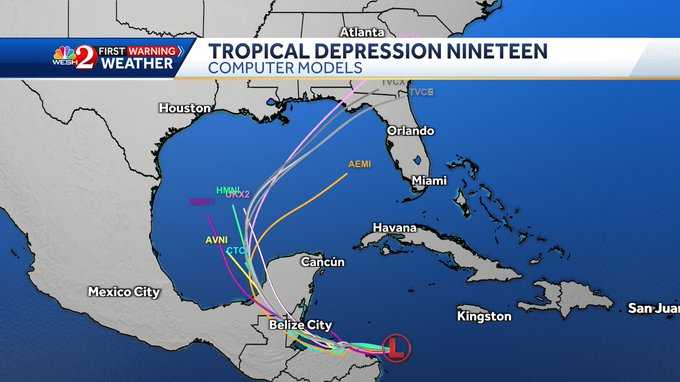
Tropical Depression 19 has formed in the Caribbean, with the potential to strengthen into Tropical Storm Sara by the weekend. Currently located 225 miles east-southeast of Isla Guanaja, Honduras, it poses a threat of heavy rainfall and flash flooding in Honduras and Belize. The system is expected to move into the Gulf of Mexico next week, possibly affecting Florida, though wind shear may limit its development. Tropical storm warnings are in effect for parts of Honduras and Nicaragua.
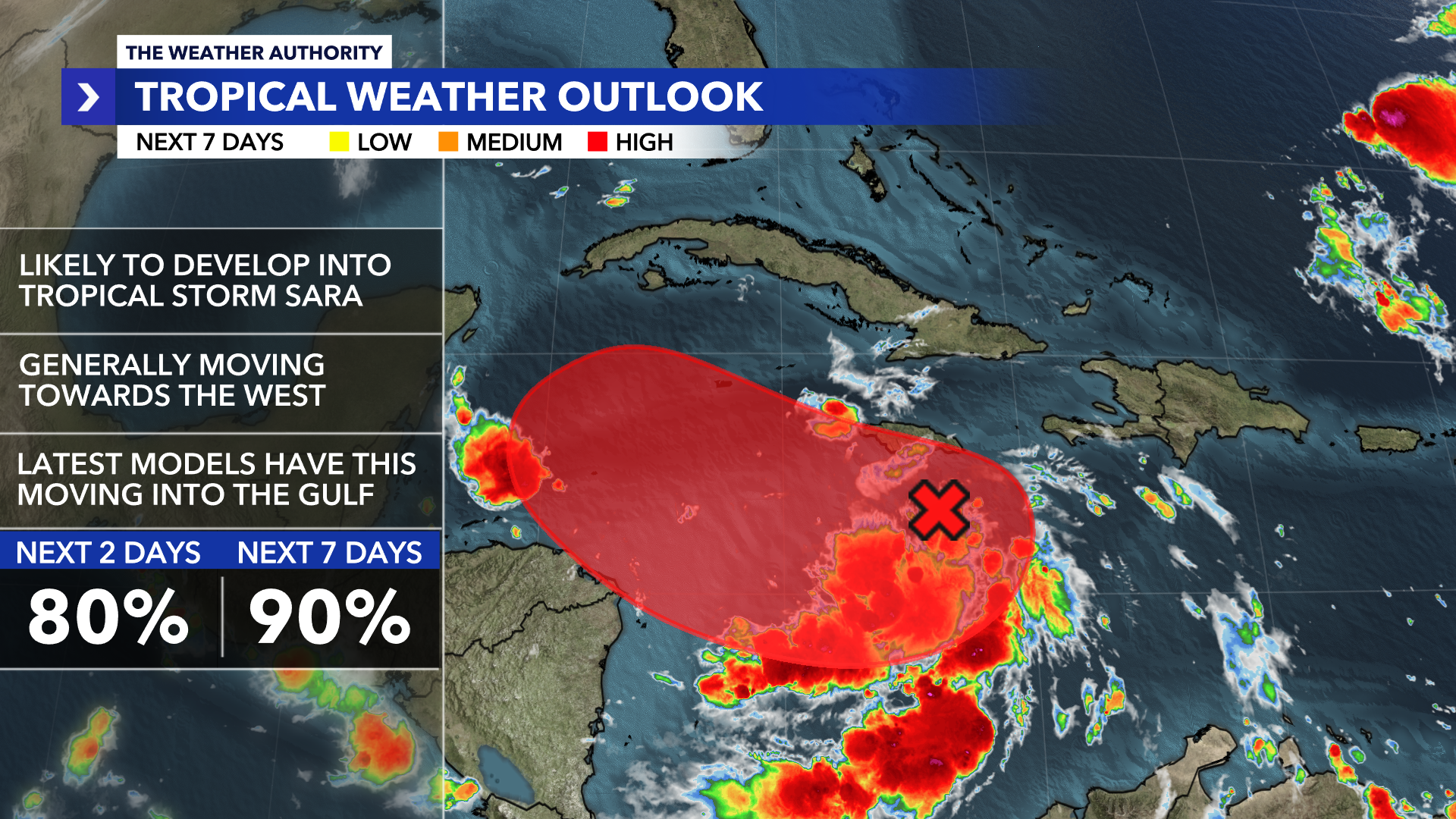
The Weather Authority is monitoring Invest 99-L, a tropical wave in the Caribbean with a 90% chance of developing into a tropical depression or Tropical Storm Sara by Thursday or Friday. Cold fronts in Florida will keep the system's moisture south through the weekend, but it is expected to move northwest by early next week, potentially entering the Gulf of Mexico. Heavy rains are forecasted for Jamaica and parts of Haiti. The system's future path and impact on Southwest Florida depend on upcoming cold fronts and wind shear conditions.