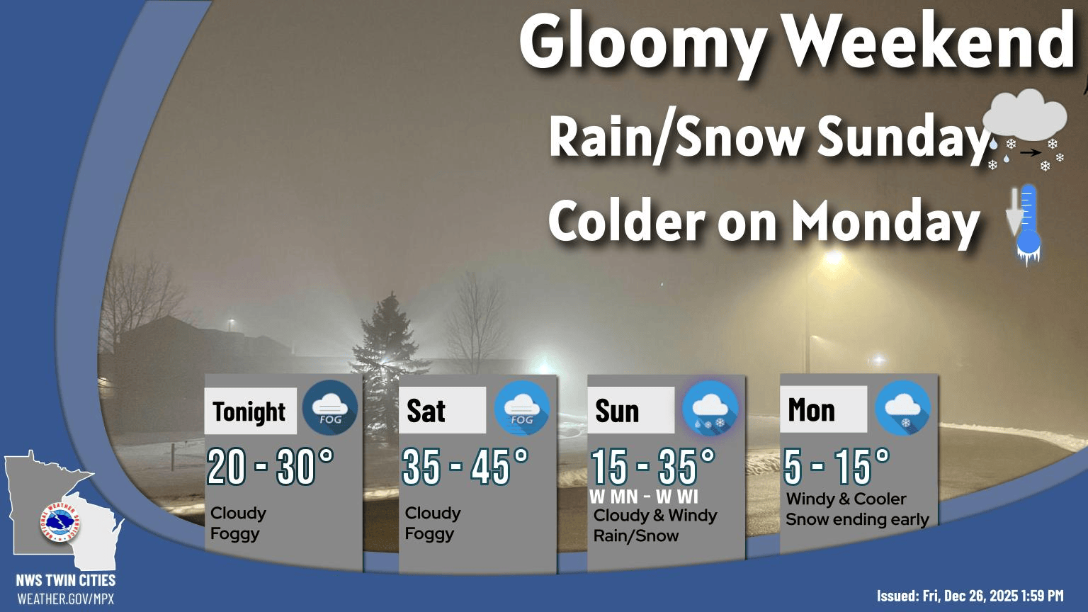
Tag

Coldfront

All articles tagged with #coldfront

First Snowfall of the Season Hits Midwest This Saturday

Originally Published 1 year ago — by KOMU 8

Featured image for First Snowfall of the Season Hits Midwest This Saturday
Source: KOMU 8

The first snow of the season is expected on Saturday, with the KOMU 8 First Alert Weather Team placing the Storm Mode Index at 2 out of 5 due to potential travel disruptions. Snow will start in the morning, becoming widespread after daybreak and exiting by afternoon, with most areas seeing 2-4 inches. A Winter Weather Advisory is in effect from 6am to 6pm, particularly along and north of I-70, where heavier snow bands may develop. Cold conditions are expected for the Mizzou gameday, with temperatures in the 30s and wind chills in the 20s. A warming trend is anticipated early next week.

Thanksgiving Travel Disrupted by Winter Storms and Cold Snap

Originally Published 1 year ago — by Just In Weather

Featured image for Thanksgiving Travel Disrupted by Winter Storms and Cold Snap
Source: Just In Weather

A series of storms is expected to impact the Eastern US during Thanksgiving week, bringing rain and colder temperatures. The main storm on Thanksgiving Day will likely cause rain in the Mid Atlantic and New England, with snow expected in western and central New York and Northern New England. The weekend will see colder air moving in, with temperatures dropping significantly across the region, including the possibility of light snow or flurries in the Mid Atlantic by Sunday.

Tropical Storm Sara Threatens Central America and U.S. with Severe Weather

Originally Published 1 year ago — by WJXT News4JAX

Featured image for Tropical Storm Sara Threatens Central America and U.S. with Severe Weather
Source: WJXT News4JAX

Tropical Storm Sara has formed in the Caribbean and is expected to bring heavy rain and potential flooding to Central America, particularly Honduras and Nicaragua, over the weekend. The storm is unlikely to impact Florida significantly due to a strong autumn cold front that will steer the storm away, resulting in only a brief period of rain in Florida next Wednesday. The system is not expected to strengthen into a hurricane as it moves into the Gulf of Mexico.

Weather Challenges for Voters on Election Day Across the U.S.

Originally Published 1 year ago — by The Washington Post

Featured image for Weather Challenges for Voters on Election Day Across the U.S.
Source: The Washington Post

On Election Day, a significant weather divide across the United States may impact voters at polling locations. A south-to-north cold front is causing unseasonably mild temperatures, 15 to 20 degrees above average, in the eastern U.S., while cooler temperatures and snow are affecting the Rockies in the west.

"Michigan Braces for Series of Impactful Winter Storms"

Originally Published 2 years ago — by MLive.com

Featured image for "Michigan Braces for Series of Impactful Winter Storms"
Source: MLive.com

Michigan is set to experience a significant shift in weather as four storm systems are predicted to bring wintry conditions after a notably warm December. The first storm will narrowly miss the state, but the subsequent systems are expected to bring a mix of rain and snow, with each storm tracking slightly further south than the last. The final storm, potentially an Alberta Clipper, could result in all snow and colder temperatures. Residents are advised to stay updated on weather changes and prepare for winter driving conditions and possible heavy snowfall in the coming days.

"Impact Day: Central Florida Braces for Intense Rain and Winds"

Originally Published 2 years ago — by WESH 2 Orlando

Featured image for "Impact Day: Central Florida Braces for Intense Rain and Winds"
Source: WESH 2 Orlando

Central Florida is bracing for an Impact Day on Saturday due to a cold front bringing heavy rain and the potential for strong to severe storms, including wind gusts and an isolated tornado. The severe weather is expected to start in the morning and clear by the evening. The Walt Disney World Half Marathon has been modified due to the forecasted conditions. Cooler temperatures will follow the front, with a dip into the 60s and a calmer Sunday expected. However, another severe weather threat may arise by Tuesday. Residents are advised to stay updated with local weather alerts.

"Impactful Saturday: Central Florida Braces for Heavy Rain and Strong Storms"

Originally Published 2 years ago — by WKMG News 6 & ClickOrlando

Featured image for "Impactful Saturday: Central Florida Braces for Heavy Rain and Strong Storms"
Source: WKMG News 6 & ClickOrlando

Central Florida is expected to experience scattered heavy rain and potential strong to severe thunderstorms due to a cold front moving through the area. The region is under a "Marginal Risk" for severe weather, with possible hazards including lightning, strong wind gusts, localized flooding, and a chance of tornadoes. Conditions are expected to improve by the evening as the front moves south, with another round of storms anticipated on Tuesday.

"Variable Weather Ahead: From Soggy Saturdays to Severe Storms and Pleasant Weekends"

Originally Published 2 years ago — by WJCL News Savannah

Featured image for "Variable Weather Ahead: From Soggy Saturdays to Severe Storms and Pleasant Weekends"
Source: WJCL News Savannah

WJCL 22 has declared an Alert Day for Tuesday due to a potent storm system expected to bring severe weather to the Southeast, including southeast Georgia and the Lowcountry. Forecast models predict thunderstorms with possible heavy rain, hail, gusty winds, and isolated tornadoes. The severity of the weather will depend on the timing of the storms and the level of atmospheric instability. The Storm Prediction Center has highlighted a risk area from Florida to North Carolina. Prior to the storms, windy conditions with gusts up to 40 mph are expected. Cooler temperatures will follow the cold front midweek. Residents are advised to stay updated with the latest forecasts and remain weather aware.

"DC Region Braces for Weekend Snowstorm with Rookie Plow Crews and Expected Shift to Rain"

Originally Published 2 years ago — by The Washington Post

Featured image for "DC Region Braces for Weekend Snowstorm with Rookie Plow Crews and Expected Shift to Rain"
Source: The Washington Post

The Washington D.C. area is experiencing cold and blustery conditions today, with a forecast of snow and rain on Saturday. The snow is expected to quickly turn to sleet and rain, particularly west of Interstate 95, where light accumulations are possible before the changeover. Temperatures will remain seasonably cold throughout the weekend, with a potential for light snow accumulation on Saturday before transitioning to rain in the afternoon. High pressure on Monday will bring sunnier skies and slightly warmer temperatures.

"Weekend Weather Watch: From Scattered Snow Showers to Persistent Cold and Potential Squalls"

Originally Published 2 years ago — by WMUR Manchester

Featured image for "Weekend Weather Watch: From Scattered Snow Showers to Persistent Cold and Potential Squalls"
Source: WMUR Manchester

The weather forecast indicates a mostly cloudy Thursday with a few scattered snow showers, particularly in northern areas and across the mountains, with gusty winds making temperatures feel cooler. Highs will reach the upper 30s before dropping in the evening. Friday will be sunny and brisk, leading to a quiet start to the weekend. However, a potential storm late Saturday night into Sunday could bring the first widespread snow of the season, with the storm's track determining the snowfall amount and impact. Weather updates will become more certain as the week progresses.

"Maine Braces for Old Man Winter's Return with Impending Snowstorms"

Originally Published 2 years ago — by WGME

Featured image for "Maine Braces for Old Man Winter's Return with Impending Snowstorms"
Source: WGME

Maine is experiencing quiet weather which will continue into Wednesday, with a mild high around 40 degrees. A cold front on Thursday could bring flurries and snow showers, particularly in Midcoast and Down East Maine, followed by a drop in temperatures into the 20s for the weekend. Confidence is growing in a widespread snowfall on Sunday, with southern Maine potentially receiving higher totals. The weather pattern remains active, with another storm possible by midweek next week.