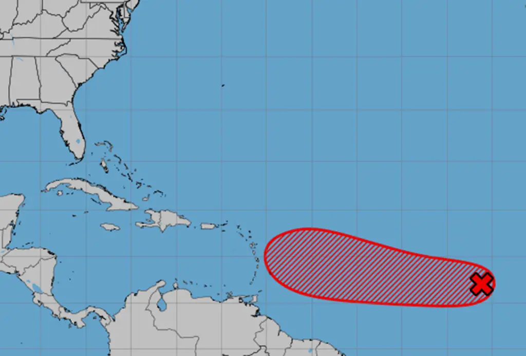
The National Hurricane Center is monitoring a developing system in the Atlantic, with a high chance of becoming a tropical depression or storm, potentially impacting the Caribbean and possibly threatening Florida, as it moves westward and could become Tropical Storm Gabrielle.
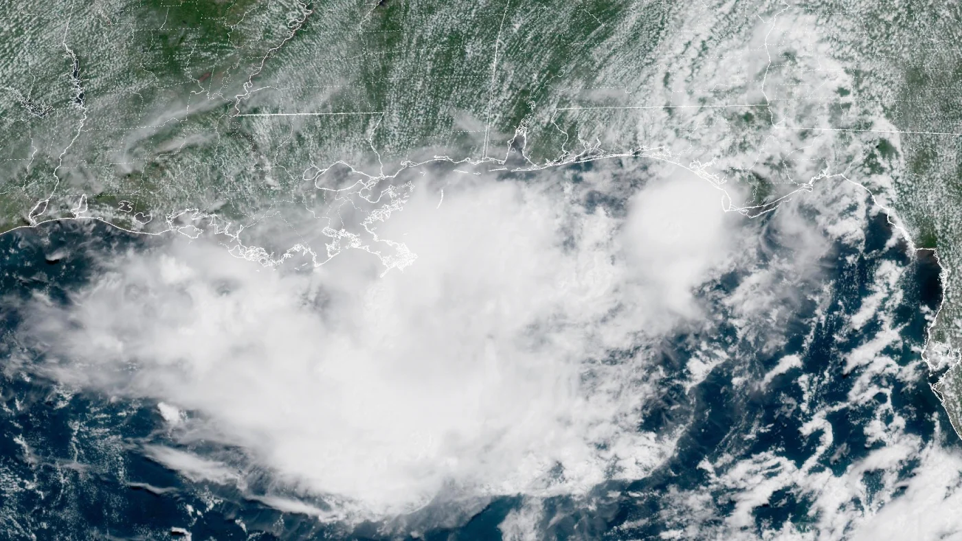
A weather system over Florida is likely to develop into a tropical depression and pose flooding risks to the Gulf Coast, especially Louisiana and New Orleans, with heavy rains expected and preparations underway amid recent severe floods in the region.
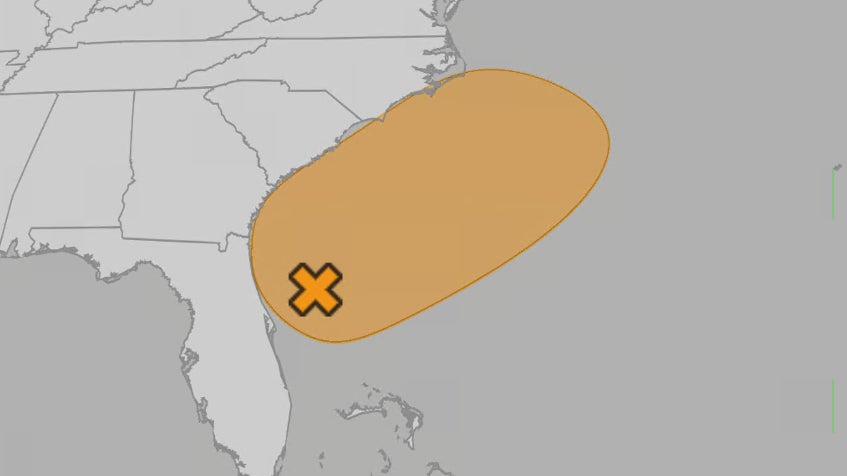
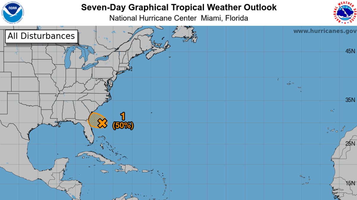
A potential tropical depression off the southeastern US coast could bring heavy rain and flash flooding to Florida and nearby states this weekend, with forecasters monitoring its development amid an above-average hurricane season influenced by climate change.
A 50% chance of a tropical or subtropical depression forming near Florida or off the Southeast coast over the holiday weekend, with stormy weather, gusty winds, and potential flash flooding expected across Florida, Georgia, and the Carolinas, regardless of whether a depression develops.
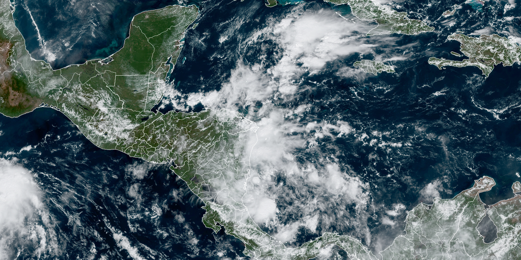
A tropical depression near southeast Mexico is expected to strengthen into a tropical storm and make landfall by Sunday night, bringing heavy rains to parts of Guatemala and Mexico.
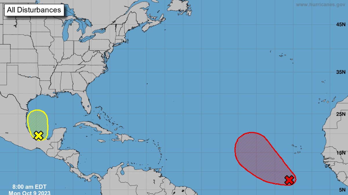
A broad area of low pressure is expected to form over the western Caribbean Sea, with potential to develop into a tropical depression later this week or weekend, as the 2024 Atlantic hurricane season nears its end. The National Hurricane Center is monitoring this system, giving it a medium chance of development over the next seven days. This follows the dissipation of Tropical Storm Rafael, which had previously been a major hurricane.
The National Hurricane Center is monitoring two disturbances that could develop into tropical depressions. Invest 92L, located off the northeastern Florida coast, may approach Florida or Georgia and bring heavy rain, gusty winds, and dangerous rip currents. Another disturbance in the southwestern Gulf of Mexico has a 60% chance of development and could become a tropical depression this weekend, potentially impacting the Gulf coast of Mexico.
Invest 95L off the Central American coast in the southwestern Caribbean Sea is showing signs of organization and could become a tropical depression before moving inland over Nicaragua by early Tuesday. Regardless of development, heavy rain is expected, which could lead to flash flooding and mudslides in Central America. The National Hurricane Center gives Invest 95L a medium chance of development over the next two days.
Hurricane Tammy is moving away from the Caribbean's Leeward Islands, while the National Hurricane Center is monitoring another system that could develop into a tropical depression or storm. Tammy's path may take it towards Bermuda, but all tropical watches and warnings have been lifted for the northern Leeward Islands. The trailing rains from Tammy could cause flooding and mudslide threats, and wave heights offshore could reach 25 feet. The NHC has increased the chances of a system in the southwestern Caribbean developing, with a 50% chance of formation in the next two to seven days.
Tropical Disturbance Invest 94L, currently a large area of low pressure with disorganized thunderstorms, is expected to develop into at least a tropical depression this week as it moves towards the northeastern Caribbean islands. The strength of the system will determine its track, with a weaker system more likely to directly affect the islands and a stronger system potentially turning north. The latest computer forecasts favor a weaker system, but confidence in any one forecast is low until an organized system forms. There is no threat to the U.S. or surrounding areas, as a cold front will block any westward path. Tropical Depression Sean is dissipating in the central Atlantic, while a broad area of low pressure over Central America is expected to gain strength in the coming weeks.
The National Hurricane Center is monitoring two storm systems, including Invest 92L in the eastern Atlantic, which is expected to strengthen into a tropical depression as it moves west-northwest. Another system in the southwestern Gulf of Mexico has a low chance of development but could bring clouds, rain, and rough surf to the northern Gulf coast and Florida. Residents are advised to stay updated and prepared for potential impacts.
Tropical Storm Philippe is moving west towards the eastern Caribbean but is expected to weaken due to increasing wind shear. Meanwhile, a tropical depression is likely to form off Africa and follow Philippe. The system off Africa has a 90% chance of developing within seven days. So far this hurricane season, there have been 16 named storms, including three major hurricanes.
Tropical depression Ophelia is expected to bring heavy rain and strong winds to the D.C. area, with flood watches and warnings in effect. Maryland and Virginia have declared a state of emergency due to the projected rainfall and potential flooding. The storm is expected to taper off overnight, but lingering showers and drizzle may continue into Sunday. Several events have been canceled, and residents are advised to take precautions against flooding and downed trees.
The 15th tropical depression of the season has formed in the central tropical Atlantic and is expected to strengthen into a tropical storm named Nigel within the next 24 hours. The depression is moving northwest and could potentially become a hurricane by early next week. However, it is not expected to pose a threat to the Lowcountry coast. Meanwhile, Hurricane Lee remains a Category 1 hurricane and has triggered tropical storm warnings for Bermuda and parts of Canada. Along the South Carolina coast, Lee has prompted a high surf advisory and a high risk of rip currents.
Two disturbances in the Atlantic Ocean have merged to form an elongated low, with a high chance of becoming a tropical depression over the next seven days, according to the National Hurricane Center (NHC). The system, previously identified as Invest 97L and Invest 98L, now has a 70% chance of developing into a tropical depression by the weekend. The NHC expects gradual development as the system moves west-northwestward or northwestward across the central tropical Atlantic. If it becomes a tropical storm, it will be named Nigel.