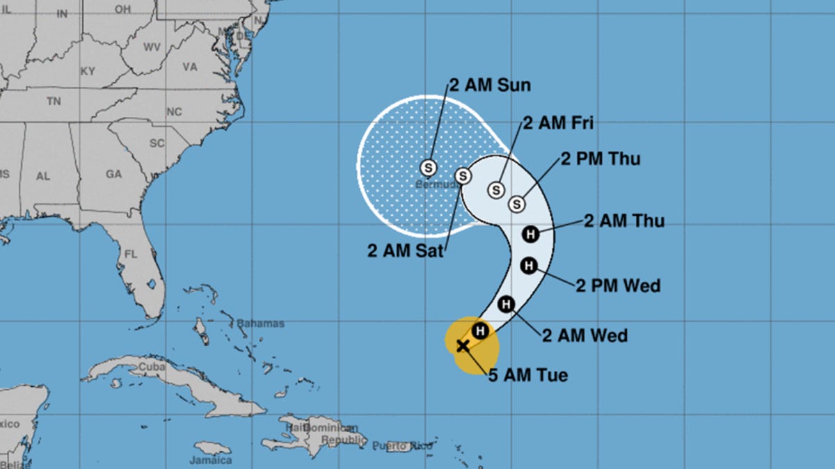
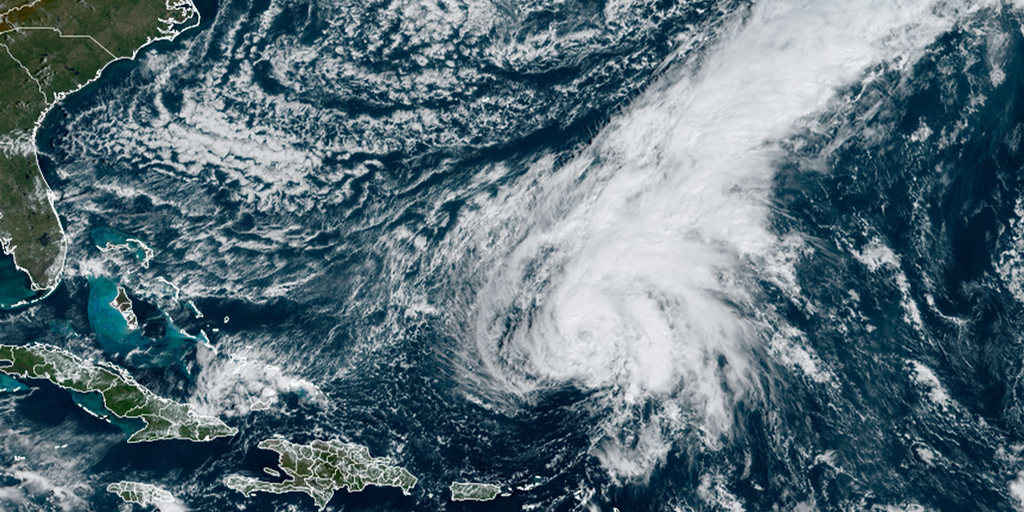
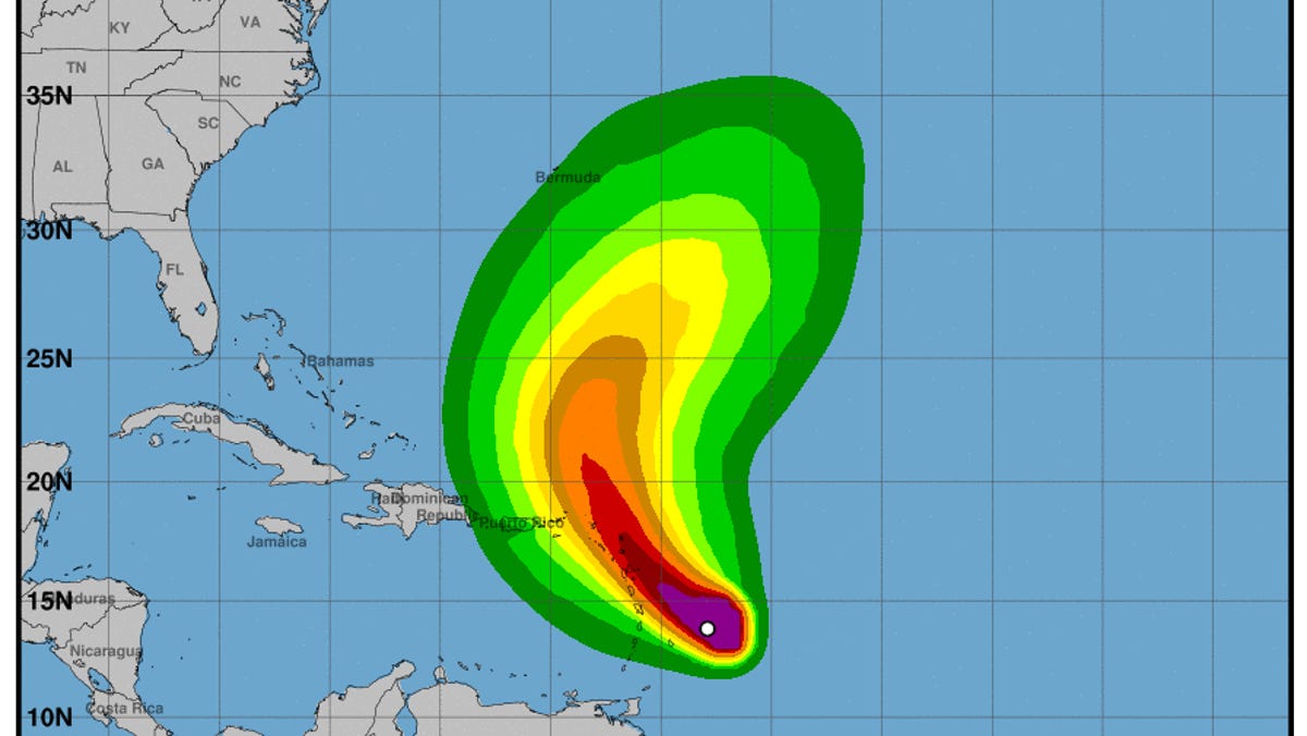
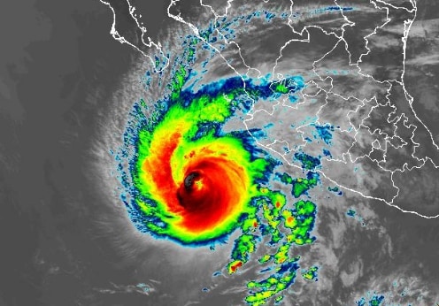
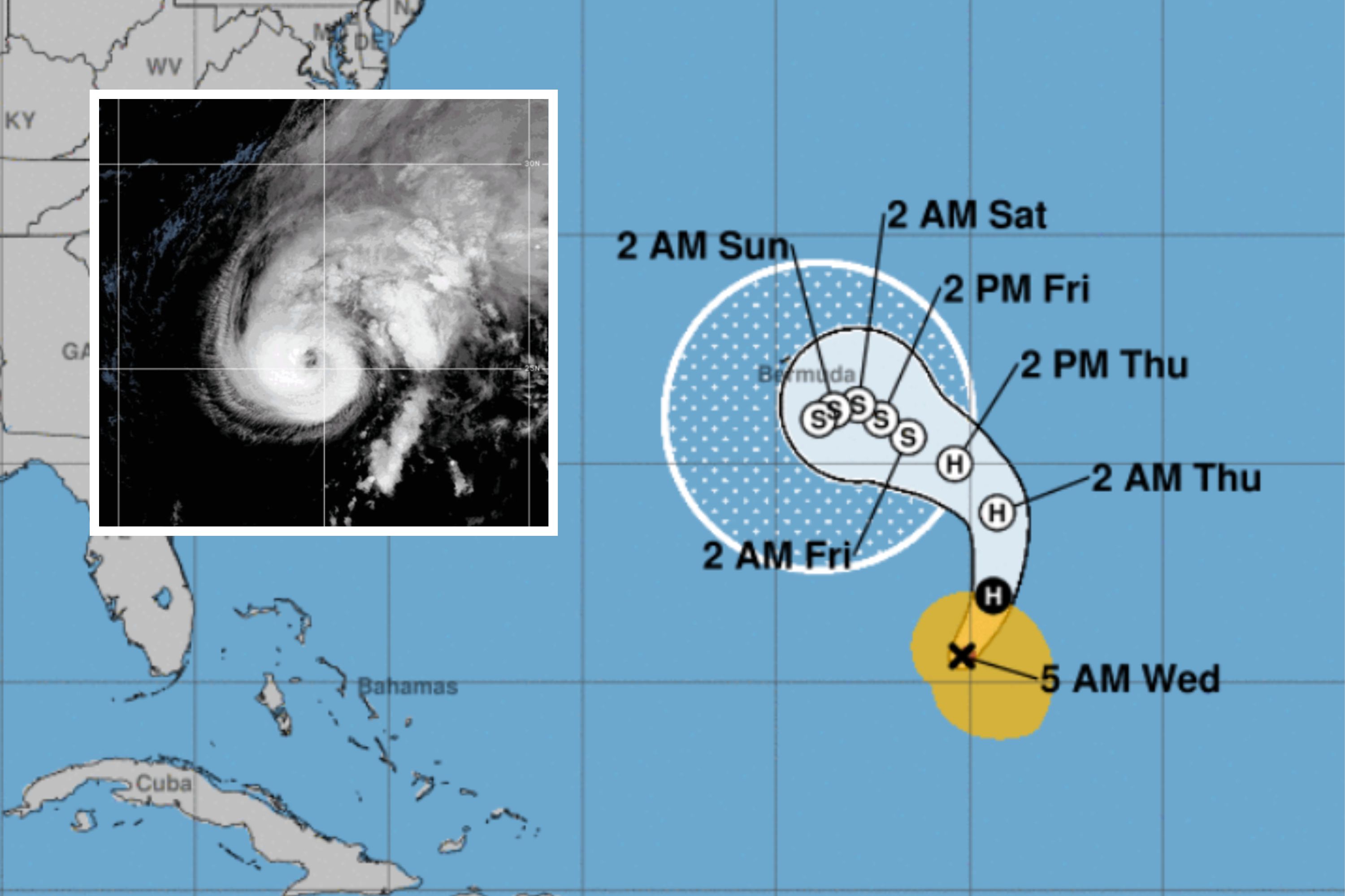
Hurricane Tammy, currently a Category 1 hurricane, has multiple potential paths according to spaghetti models, including landfall in Florida or North Carolina, or veering into the Atlantic. Spaghetti models represent different weather model forecasts and help compare predictions. The uncertainty in Tammy's path is due to factors such as the placement of middle latitude troughs and the storm's interaction with them. Late-season hurricanes like Tammy are more likely to interact with troughs, making their tracks more uncertain. The National Hurricane Center forecasts Tammy to move west towards Bermuda and weaken in the coming days.
Hurricane Tammy is forecasted to move towards the North Carolina coast by the weekend, potentially bringing rough surf conditions. The storm is currently located south-southeast of Bermuda with winds of 75 mph. It is expected to remain at hurricane strength through Tuesday and Wednesday before weakening to a tropical storm on Thursday. While the storm is predicted to weaken and not have significant impacts on land, the Wilmington area may experience maritime impacts, including increased risk for rip currents along the coast. No watches or warnings are currently in effect.
Hurricane Tammy, currently a Category 1 storm, is expected to weaken and become a post-tropical cyclone by Thursday. It is projected to move towards Bermuda, potentially bringing tropical storm conditions to the island this weekend. The storm has already impacted the northeastern Caribbean islands with hurricane-force winds and heavy rain. Large waves and life-threatening surf are expected to affect portions of the Leeward Islands, the U.S. and British Virgin Islands, and Puerto Rico. Hurricane Tammy made landfall on Barbuda with maximum sustained winds of 85 mph before heading northwestward away from the islands.
The tropics remain active for the last full week of October, with Hurricane Tammy potentially threatening Bermuda with heavy rain and gusty winds. Another system, Invest 95L, has a medium chance of developing into a tropical depression or tropical storm before moving inland over Central America. Meanwhile, the remnants of Hurricane Norma are expected to make a second landfall in Mexico, providing much-needed rainfall for the southern Plains.
Tropical Storm Norma is moving into mainland Mexico, bringing threats of flash flooding and heavy rainfall. Meanwhile, Hurricane Tammy made landfall in Barbuda. Norma, once a Category 4 hurricane, weakened to a tropical storm as it crossed the Baja California Peninsula. President Andrés Manuel López Obrador reported no loss of life from the storm. The slow-moving storms have the potential to cause severe flooding and authorities are urging residents to take necessary precautions.
Hurricane Tammy is moving away from the Caribbean's Leeward Islands, while the National Hurricane Center is monitoring another system that could develop into a tropical depression or storm. Tammy's path may take it towards Bermuda, but all tropical watches and warnings have been lifted for the northern Leeward Islands. The trailing rains from Tammy could cause flooding and mudslide threats, and wave heights offshore could reach 25 feet. The NHC has increased the chances of a system in the southwestern Caribbean developing, with a 50% chance of formation in the next two to seven days.
Hurricane Norma made landfall near Los Cabos in Mexico's Baja California Peninsula, while Hurricane Tammy hit Barbuda in the Caribbean. Both storms were Category 1 hurricanes. Norma weakened to a tropical storm as it crossed the Baja California Peninsula, bringing heavy rain and the possibility of severe flooding. Little damage was initially reported, but the area remains vulnerable. Tammy, hitting two weeks after Tropical Storm Philippe, is expected to bring heavy rainfall and flooding to the Lesser Antilles.
Hurricane Norma is heading towards Mexico's Los Cabos resorts, prompting residents to prepare for its expected landfall on Saturday. The hurricane has weakened slightly to a Category 2 storm but is still a major threat, with the potential for severe flooding due to its slow pace. Meanwhile, Hurricane Tammy is threatening the islands of the Lesser Antilles in the Atlantic, with hurricane warnings issued for several islands. Residents are bracing for heavy rainfall and potential flooding, particularly in Antigua and Barbuda, which are still recovering from previous storms.
Hurricane Norma is expected to hit Mexico's Los Cabos resort area with destructive winds, flash flooding, and a dangerous storm surge, while Hurricane Tammy bears down on the Leeward Islands. Norma, a Category 2 storm, is forecasted to make landfall in Baja California Sur, including Cabo San Lucas, bringing life-threatening conditions. Tammy, a Category 1 storm, has triggered hurricane warnings for the Leeward Islands. Both storms are not a threat to the US. Heavy rainfall, flooding, and strong winds are expected in the affected areas.
Twin hurricane warnings have been issued in the Caribbean and Mexico, with Hurricane Tammy threatening the Leeward and Windward Islands and Hurricane Norma expected to hit areas around Cabo San Lucas. The storms could bring life-threatening surf, storm surges, heavy rainfall, and the risk of flash flooding and mudslides. The unusual late-season hurricanes are attributed to the warm Atlantic Ocean linked to the El Niño weather pattern.
Hurricane Norma is approaching Los Cabos in Mexico with maximum sustained winds of 110 mph, while newly formed Hurricane Tammy is heading towards the Caribbean with winds of 75 mph. Both storms have prompted hurricane warnings in their respective regions, but are not direct threats to the mainland U.S. Norma is expected to bring heavy rain and potential flooding to the southern portion of Baja California, while Tammy may cause flash floods and mudslides in the Leeward Islands.
Hurricane Tammy is strengthening in the tropical Atlantic and is expected to become a category 1 hurricane as it approaches the Leeward Islands. The storm is likely to pass near or over the islands, with Barbuda expected to be the most impacted. Heavy rains and winds are predicted, with Puerto Rico and the Virgin Islands expected to receive lesser amounts. Hurricane Norma, approaching Mexico's Baja Peninsula, has weakened to a category 2 hurricane and is expected to weaken further due to increased wind shear and dry air. The storm is forecasted to pass close to or over the southern tip of the Baja Peninsula before making landfall north of Mazatlan. In the north Indian Ocean, Tropical Cyclone 05A is predicted to intensify to a category 3 storm, while disturbance 92B in the Bay of Bengal has the potential to develop into a tropical depression.
Hurricane Tammy has strengthened and is heading towards the Caribbean islands. Tropical storm conditions are expected to start in the Lesser Antilles islands, with hurricane conditions predicted in portions of the Leeward Islands. Tammy is expected to bring heavy rains, flash flooding, and potential mudslides to several areas. Storm surge could also bring sea waters inland in coastal areas. Various storm warnings and watches are in effect, and additional ones may be issued. The hurricane season, which has seen above-average activity, doesn't end until November 30.
Hurricane Norma, now a Category 4 storm, threatens Baja California with heavy rain, flooding, and mudslides, while Tropical Storm Tammy nears the Caribbean with the potential to become a Category 1 hurricane. Both storms could generate life-threatening swells and rip currents. Norma's maximum sustained winds rapidly intensified, and it is forecasted to reach the southern tip of Baja California this weekend. Tammy is expected to bring heavy rain and isolated flooding to the Lesser Antilles, Virgin Islands, and Puerto Rico.