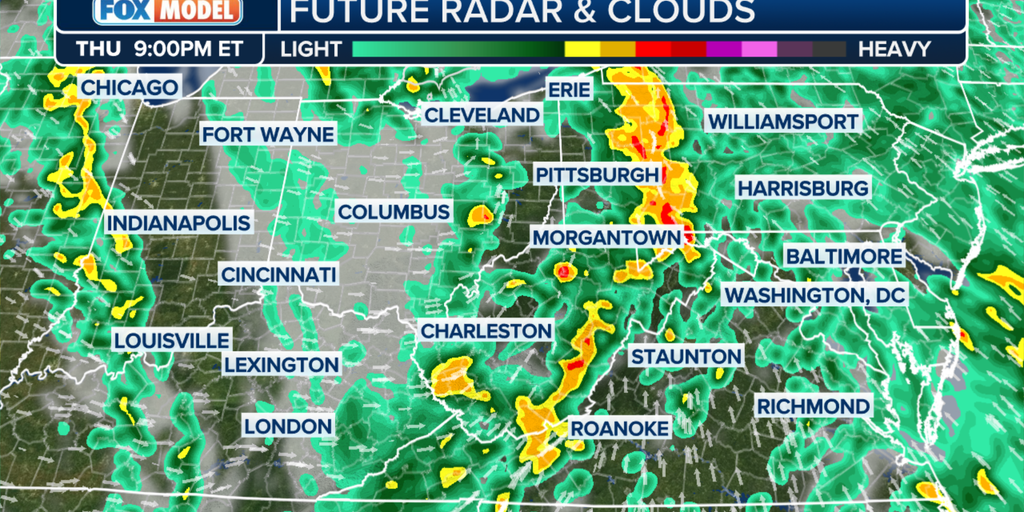
A severe weather event is expected in the Philly region with a tornado watch until late Friday, heavy rains, and a rare flood watch, potentially causing minor flooding and impacting local agriculture, while drought conditions persist despite recent rainfall.
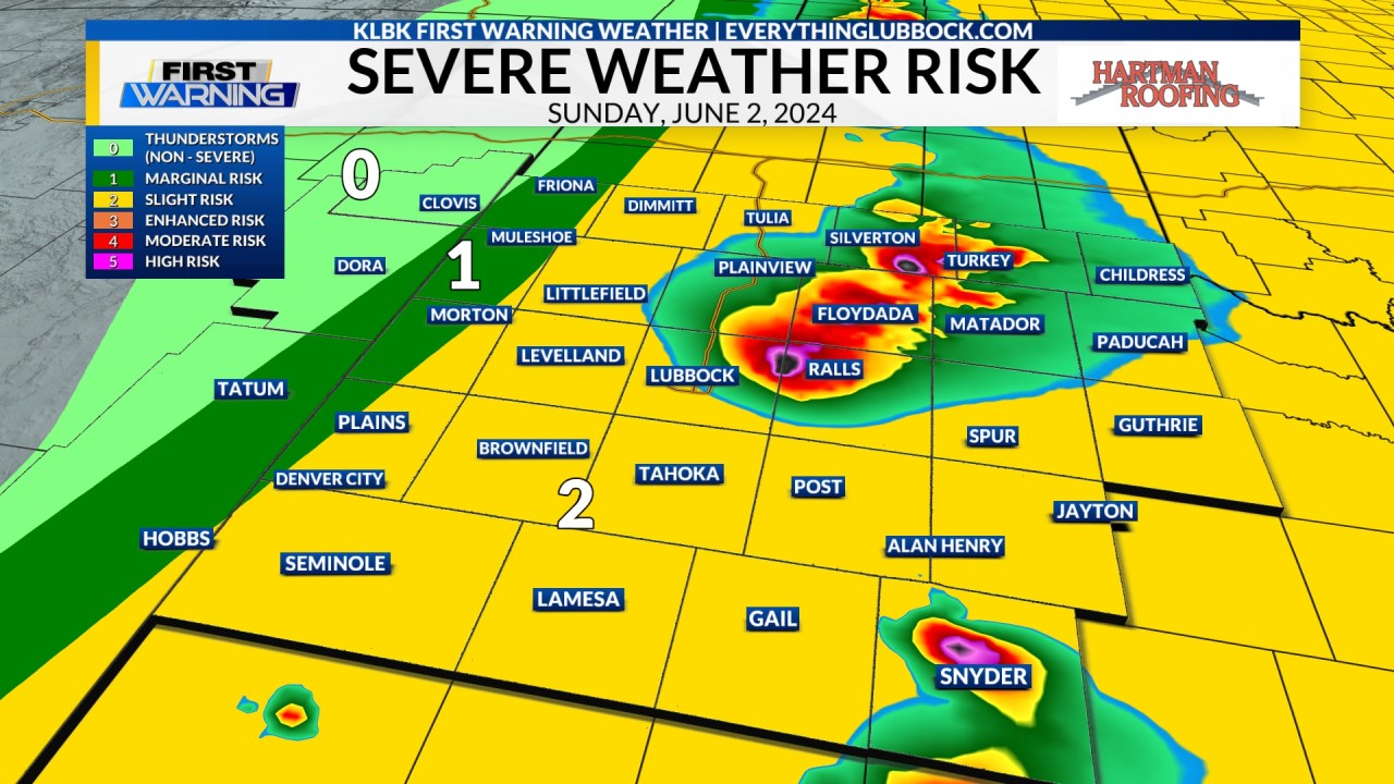
A Weather Aware Day has been issued for June 2, 2024, across the South Plains due to the potential for severe weather, including damaging winds, large hail, isolated tornadoes, and localized flooding. A Tornado Watch is in effect for multiple counties until 11 PM CDT. Residents are advised to stay informed and take necessary precautions.
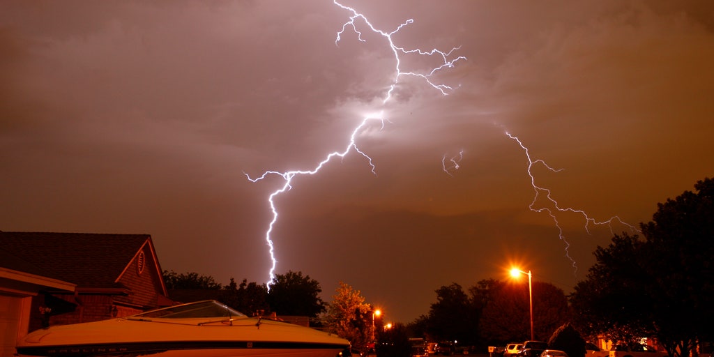
A Tornado Watch has been issued for several counties in the Ozarks, lasting until 10 a.m. on Sunday. The KY3 First Alert Weather Team is monitoring the potential for severe weather along a line of storms. Residents are advised to stay informed through alerts and the KY3 First Alert Weather App.
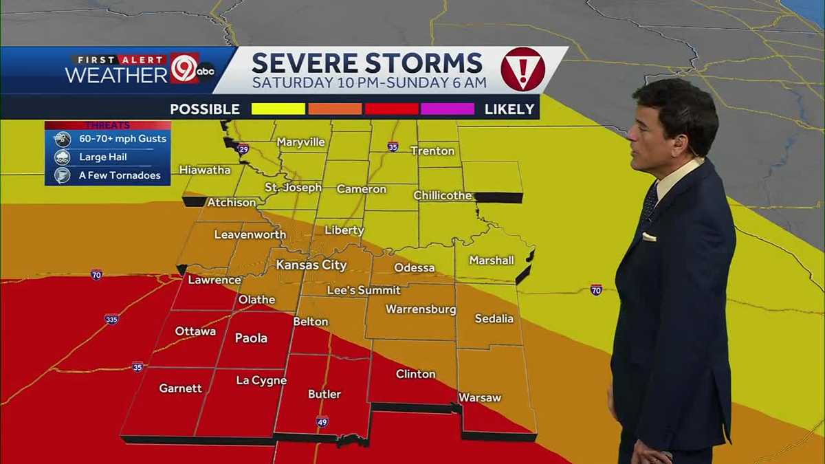
Severe thunderstorms, including the potential for tornadoes, large hail, and damaging winds, are expected to hit the Kansas City area overnight from Saturday into Sunday morning. A tornado watch is in effect for several counties until 5 a.m. Sunday. Residents are advised to stay weather-aware and have multiple ways to receive alerts. The weather will calm down by Memorial Day, which is expected to be comfortable and dry.
The National Weather Service has issued a "particularly dangerous situation" tornado watch for parts of northern Texas, central Oklahoma, and south-central Kansas, indicating a high likelihood of multiple strong tornadoes, large hail, and damaging winds. The watch, which includes cities like Wichita and Oklahoma City, will expire at 11 p.m. CT. Additional tornado watches and severe weather warnings are in effect for other regions, with millions of Americans under threat from severe thunderstorms and extreme heat over the Memorial Day weekend.
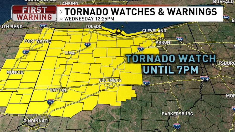
A tornado watch has been issued for more than a dozen counties in northeast Indiana and parts of Ohio until 7 p.m. Wednesday, with the possibility of developing storms bringing hail and wind gusts of up to 70 mph. The National Weather Service advises that the severe weather threat in northeast central Indiana will diminish by early evening, but will continue into Ohio. Residents are urged to have a safety plan in place, including seeking shelter in a basement or interior room during a tornado, and to stay updated on weather alerts.
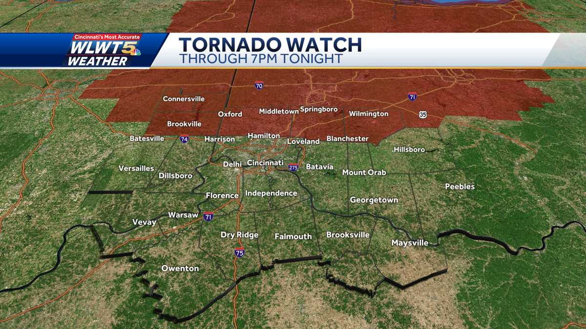
A tornado watch has been issued for parts of Greater Cincinnati until 7 p.m., with the main threats being gusty winds and hail. There is potential for a secondary line of storms to develop in the early to mid-afternoon, and a cold front is expected to bring cooler air for the weekend.
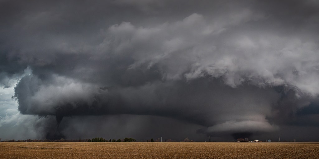
A Tornado Watch has been issued for parts of the Ohio Valley and southern Great Lakes as severe storms, including tornadoes, damaging wind gusts, and large hail, are expected to hit the region. At least 17 tornadoes were reported in the Midwest on Tuesday, with a new system forecasted to bring severe weather to the South on Thursday. The cold front will also bring much cooler air to the central and southern Plains, with below-average temperatures expected to reach most areas east of the Rockies by the weekend.
A Tornado Watch is in effect for central, northern, and western Ohio until 7 p.m., with the potential for strong to severe storms later in the day. Morning rain is expected to give way to partly cloudy skies and temperatures in the upper 70s, with brisk winds aiding in temperature increase. Severe storms with damaging winds, large hail, and isolated tornadoes are possible, particularly in Northern Ohio. Showers and storms are likely early Friday, followed by a cool and dry weekend.
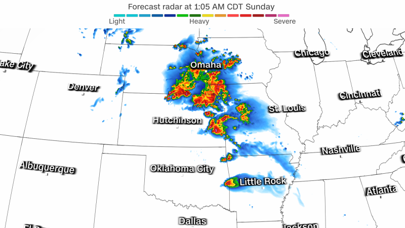
A Tornado Watch has been issued for parts of the Midwest, including Kansas City, as severe storms threaten the region with very large hail, destructive wind gusts, and a few tornadoes. The storms are expected to continue into the overnight hours, with Iowa seeing its first widespread severe weather threat for 2024. The severe weather ingredients are lining up to produce the greatest chance of supercells capable of spawning tornadoes, and the threat will shift to the southern Great Lakes and the Ohio Valley on Wednesday.
Severe storms are expected in much of Nebraska Monday night into Tuesday morning, with an enhanced risk for large hail, damaging winds, and several tornadoes. A Severe Thunderstorm Watch is in place for central Nebraska until midnight, and a Tornado Watch is in place for south central Nebraska and northern Kansas until 3 AM Tuesday. The main threat will be large hail and damaging winds, with the potential for isolated tornadoes. Rain and thunderstorms are expected to continue through Thursday before drier and cooler weather arrives for the end of the week.
A Tornado Watch has been issued for parts of the Appalachia region as severe thunderstorms are expected to develop along the Appalachian Mountains, bringing the risk of hail, damaging winds, and isolated tornadoes. This stormy weather is part of the same system that caused damage and flooding along the Gulf Coast. The storms are anticipated to redevelop ahead of a cold front, with communities in West Virginia, Virginia, and North Carolina under the watch box. In addition to the severe weather threat, dangerous lightning and heavy rainfall are also expected, which could worsen ongoing cleanup efforts in areas already affected by flooding. Flood Watches have been posted for parts of the region, and the Northeast could see scattered rain showers for several days as the cold front moves through.
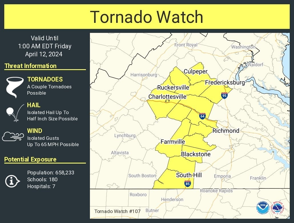
A tornado watch has been issued for Central Virginia, including Culpeper and Fredericksburg, until 1 a.m., with the possibility of strong storms affecting the D.C. area. The National Weather Service warns of intense storms with potential wind damage and the chance of isolated tornadoes. Residents are advised to stay alert and seek shelter if a tornado warning is issued. Showers and storms are expected to continue into the evening, with temperatures dropping tomorrow and the possibility of some showers or storms in the afternoon.
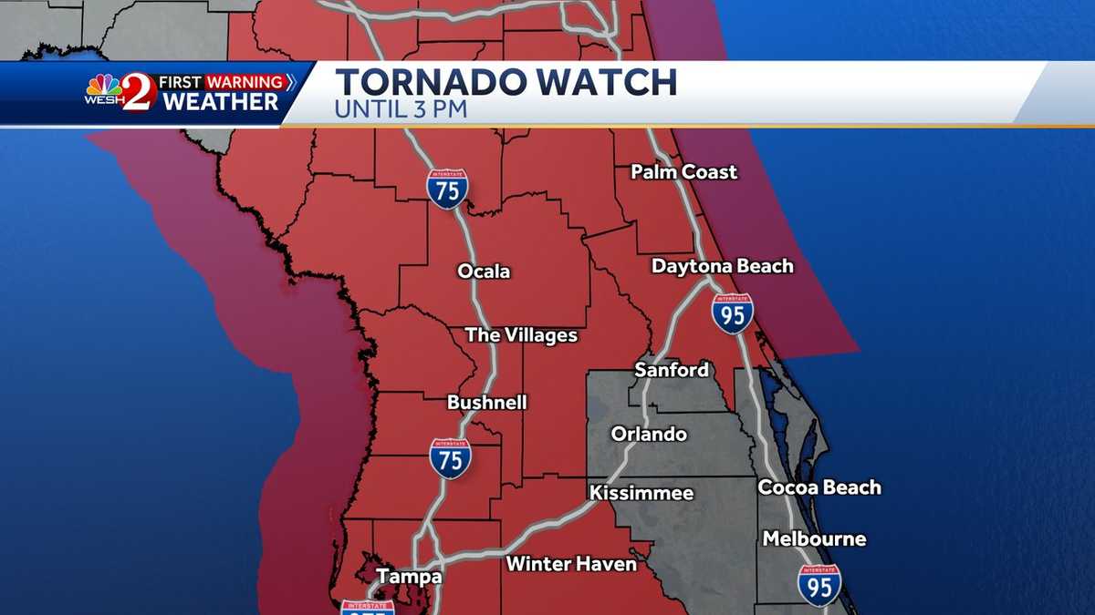
A tornado watch has been issued for parts of Central Florida, including Marion, Flagler, Volusia, Sumter, and Lake counties until 3 p.m., with severe thunderstorm warnings in effect for some areas. The forecast predicts isolated strong to severe storms with damaging winds as the main threat, particularly in the northwest of Orlando. The storms are expected to arrive around 11 a.m. and clear out by 7-8 p.m., with wind advisories in place. After the severe weather, Central Florida will experience sunny skies and lower humidity for the weekend.
A Tornado Watch has been issued for parts of Central Texas, including Austin and Waco, as a multiday severe weather outbreak begins in the South, with the potential for very large hail, damaging wind gusts, and EF-2 or stronger tornadoes. The threat covers Texas and Louisiana on Tuesday before shifting eastward into portions of Louisiana, Mississippi, and Alabama on Wednesday. The South also faces the potential for life-threatening flooding, with several cities expecting multiple inches of rain over the next few days.