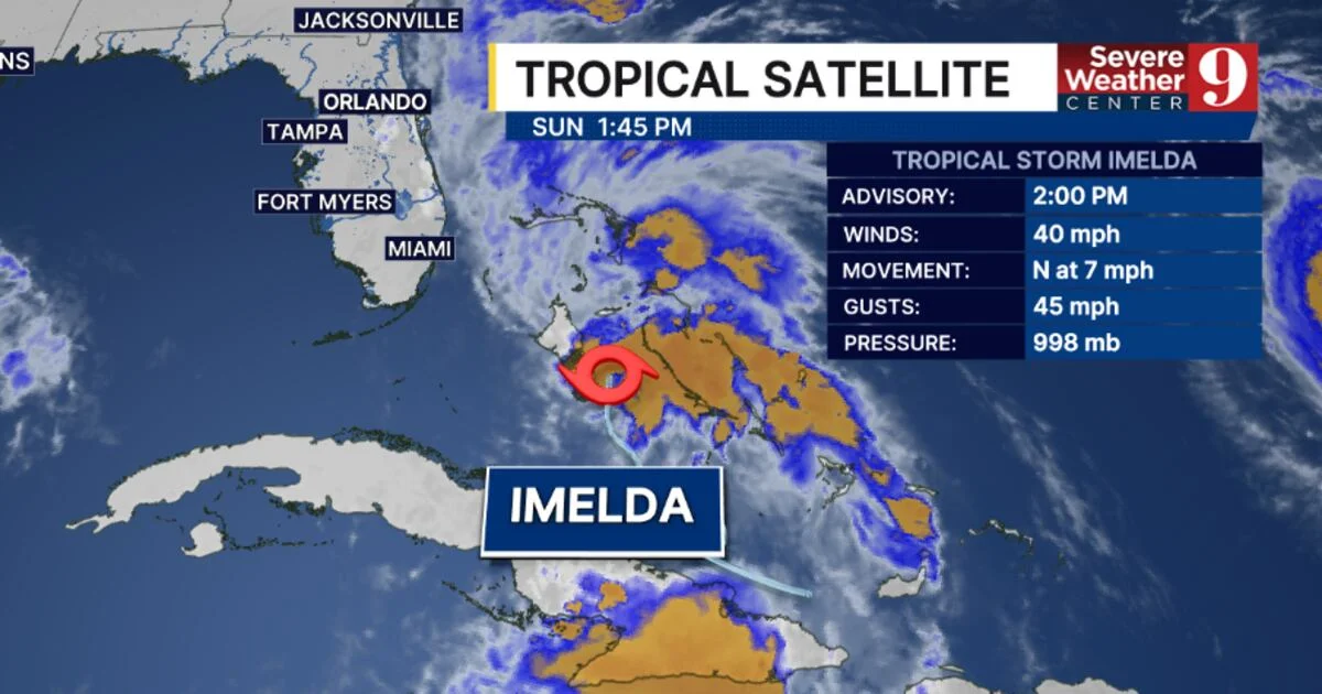
Tropical Storm Imelda, the ninth named storm of the 2025 Atlantic hurricane season, has formed near the Bahamas and is expected to pass offshore Florida, bringing gusty winds and rain with minimal flooding risk, as it is forecasted to strengthen into a hurricane by early next week.
Denver and the Front Range are bracing for a significant snowstorm on Thursday, with a cold front moving in on Wednesday and snow expected to continue throughout the day. The storm could have high-impact effects, potentially making travel inadvisable, and there is still uncertainty about snow totals and other details. The Pinpoint Weather team is closely monitoring the situation and advising people to stay prepared for potential changes.
Scientists at the 2023 Fall Meeting of the American Geophysical Union discussed the effects of asteroid impacts on early Earth, revealing that the planet was heavily bombarded by large asteroids, leading to widespread melting of the surface and the formation of impact-generated spherule layers. Modeling suggests that nearly the entire surface of Earth would have been coated with impact melt during the first billion years of its history, with evidence of impacts dating back to 3.5 billion years ago found in Australia and South Africa.
The Northeast is bracing for a powerful weekend storm that originated from the recent deadly flooding in the Pacific Northwest. The storm will bring a mix of snow, rain, and gusty winds, with impacts varying by location. Weather alerts, including a High Wind Watch, have been issued for parts of the region. Travel delays are expected in cities like New York City, Philadelphia, and Boston. Snowfall accumulations of 5 to 10 inches are possible in upstate New York and Vermont. Widespread rainfall of 1 to 3 inches is expected, with flood alerts in effect for over 40 million people. Power outages and damage to outdoor holiday decorations are also anticipated.
The Northeast is bracing for a powerful weekend storm that originated from the recent deadly flooding in the Pacific Northwest. The storm will bring a mix of snow, rain, and gusty winds, with impacts varying by location. Weather alerts have been issued, including a Winter Storm Watch, Flood Watch, and High Wind Watch. Precipitation will move from western regions to the Interstate 95 corridor by Sunday, affecting cities like Pittsburgh, Buffalo, New York City, Philadelphia, and Boston. Widespread winds of 30-40 mph, with gusts possibly reaching 60 mph, are expected. The storm will cause travel delays, power outages, and potential damage to holiday decorations.
A powerful storm system originating from the Pacific Northwest is expected to impact the Northeast, with snow, rain, and gusty winds forecasted. Various weather alerts, including a High Wind Watch, have been issued for parts of New York City, Maine, and Massachusetts. Travel delays are expected, and power outages and damage to holiday decorations are possible. Snowfall accumulations of 5-10 inches are possible in upstate New York and Vermont, while widespread rainfall totals of 1-3 inches are expected. Over 40 million people are under flood alerts, and winds of 30-40 mph with gusts up to 60 mph are anticipated.
As a government shutdown looms, millions of federal employees face furloughs or working without pay, while federal programs that many Americans rely on could be disrupted. Low-income Americans may lose access to food assistance programs like SNAP and WIC, while Head Start programs and free school lunches could be affected. Social Security and Medicare payments will continue, but delays in customer service are expected. Flights and travel may experience disruptions, with potential delays in passport processing. Student loan borrowers may face delays in seeking help or processing payments, and national parks may be closed or have limited access. The United States Postal Service will not be affected.
Hurricane Calvin maintains category 2 strength with sustained winds of 100 mph, possibly weakening to a category 1 or tropical storm as it crosses into the Central Pacific basin. The current forecast track has the center of the storm making landfall on the southern coast of Hawaii Island, but there is uncertainty regarding its exact path. Heavy rain, high winds, and high surf are expected, with the potential for downed trees and powerlines. The strength of Calvin near Hawaii is uncertain due to wind shear and drier air conditions. The Hurricane Hunters may fly reconnaissance missions if Calvin poses a threat to Hawaii.
Record-breaking global temperatures have been observed this week, with the average temperature reaching 62.9 degrees Fahrenheit, matching the previous day's record high. These extreme temperatures are a clear indication of the effects of climate change. The raging wildfires in Canada, which have burned millions of acres and displaced thousands of people, are also a result of the warming climate. As the climate continues to warm, we can expect more record-breaking heat and an increase in the frequency and intensity of wildfires. The impacts of climate change are surpassing previous expectations, and urgent action is needed to mitigate its effects.
Heavy rainfall in the Chicago area led to widespread flooding, causing expressway closures, the reversal of the Chicago River's flow, and warnings for residents to limit water usage. Some areas received up to 8 inches of rain in less than 24 hours, surpassing rainfall totals for the past couple of months combined. Records were broken at O'Hare Airport, with more than 3.3 inches of rain, marking the highest daily rainfall total since May 2020. The heavy rain also impacted sports events, including the NASCAR Street Race and a Cubs game, which experienced delays.