Tag

Eastern Iowa

All articles tagged with #eastern iowa

weather1 year ago

Mixed Precipitation Expected in Eastern Iowa: Tracking Snow and Rain for Slick Travel

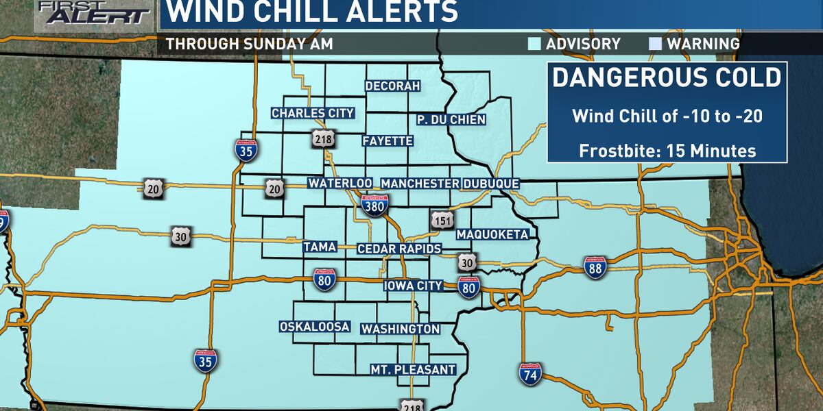
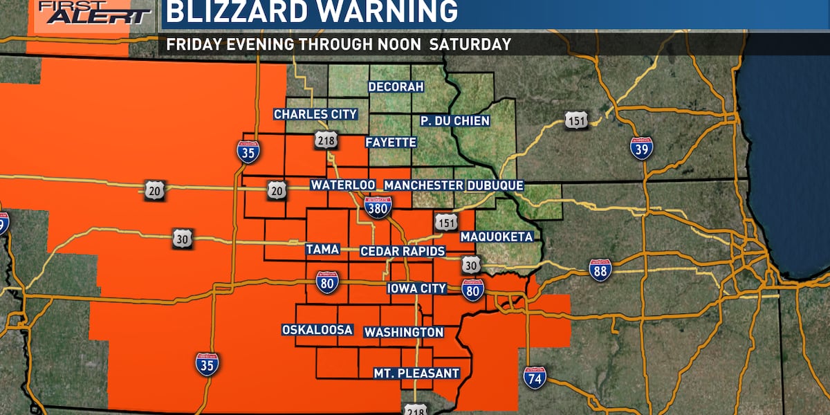
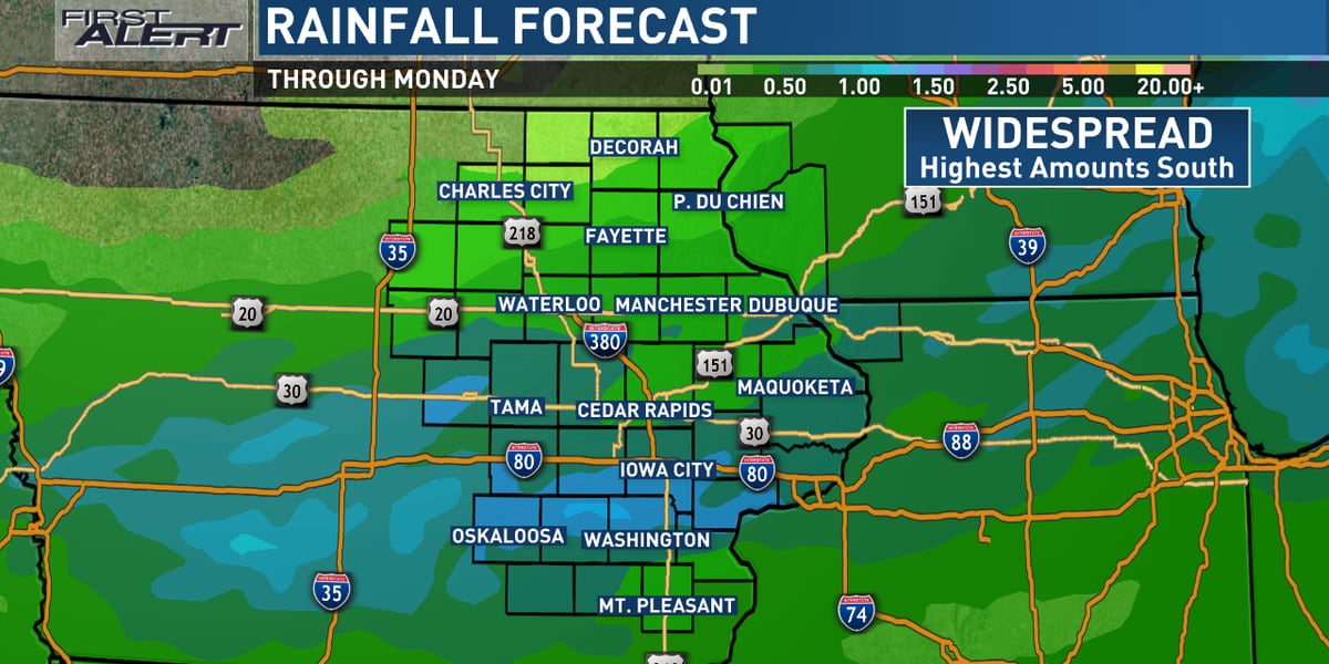
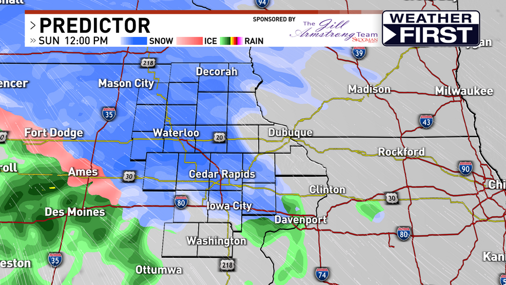
Winter Weather Advisories have been issued for parts of eastern Iowa as another round of snow moves in, with high snowfall rates leading to quickly coated roads and low visibility. The snow will transition to a wintry mix and rain through the afternoon and evening, with a sharp cutoff in accumulation expected. As temperatures rise into Monday, some melting will occur, with showers and a few thunderstorms possible as the storm continues to move through.

weather2 years ago

"Winter Weather Advisory in Effect Despite Warmer Sunday Forecast"

Eastern Iowa is experiencing very cold temperatures with wind chills in the single digits, teens, and 20s below zero, but Sunday will be a bit warmer with highs in the teens and 20s. A Winter Weather Advisory is in effect for the southern counties as a wintry mix is expected to move in late Sunday night and continue through Monday morning, potentially causing travel issues. The wintry mix, freezing rain, and snow will return Monday night and into Tuesday morning, with ice developing on roadways and surfaces. Despite the wintry precipitation, temperatures will rise into the low to mid-30s from Monday into next weekend.

weather2 years ago

"Iowa Braces for Frigid Temperatures, Heavy Snow, and Hazardous Driving Conditions"

Eastern Iowa is facing a series of weather warnings, including a Winter Storm Warning with 6-12" of snow, a Blizzard Warning with strong winds and reduced visibility, and a Wind Chill Watch with dangerously low temperatures. Travel is expected to be difficult, and residents are advised to limit travel to emergencies and prepare a Winter Survival Kit. The cold temperatures and wind chill values could cause frostbite on exposed skin in as little as 10 minutes.

weather2 years ago

Anticipated Relief: Long-awaited Rainfall Approaches

Eastern Iowa can expect much-needed rain as showers move into the area this evening and continue through the overnight hours, potentially lasting into Monday morning. Temperatures will be comfortable in the upper 50s and low 60s in the morning, rising to the low 70s on Monday afternoon. Cooler air will arrive on Tuesday and Wednesday before temperatures return to the 70s for the rest of the week and weekend.

weather2 years ago

Severe Thunderstorm Watch in Effect Until 1 PM

An air quality alert is in effect for the entire eastern Iowa area until midnight tonight due to unhealthy air caused by wildfire smoke from Canada. Storms are expected to wrap up in southern areas by 2 PM, with no rain expected in areas north of highway 20. The air quality is expected to improve throughout the day. Scattered showers and storms are possible on Friday, mainly along highway 20 and southward, with isolated storms possible in northern areas later in the day. Showers and storms are also expected on Saturday and Sunday.

weather2 years ago

Weekend Weather Update: Storms, Heat, and Isolated Showers Expected.

A Tornado Watch is in effect until 8 p.m. for part of Eastern Iowa. A line of showers and storms will move into Eastern Iowa overnight and one or two of these storms could become strong to severe. Scattered showers are in the forecast for Mother’s Day with the best chance for rain along and north of Highway-20. Temperatures will also be much cooler on Sunday with highs staying in the 50s and 60s. However, temperatures will rise back into the 70s for the upcoming workweek.

weather2 years ago

Stormy Sunday and Beyond: Weather Update.

Eastern Iowa will experience a foggy morning followed by a chance of strong to severe storms in the afternoon and overnight hours, with the possibility of tornadoes, high winds, and hail. Temperatures will be in the 80s. The rest of the week will be warm and dry, but more showers and storms are possible on Friday and through Mother's Day weekend.