Tag

Weather Systems

All articles tagged with #weather systems

weather1 year ago

"Double Trouble: Consecutive Snow Systems Set to Hit Midwest and Great Lakes"

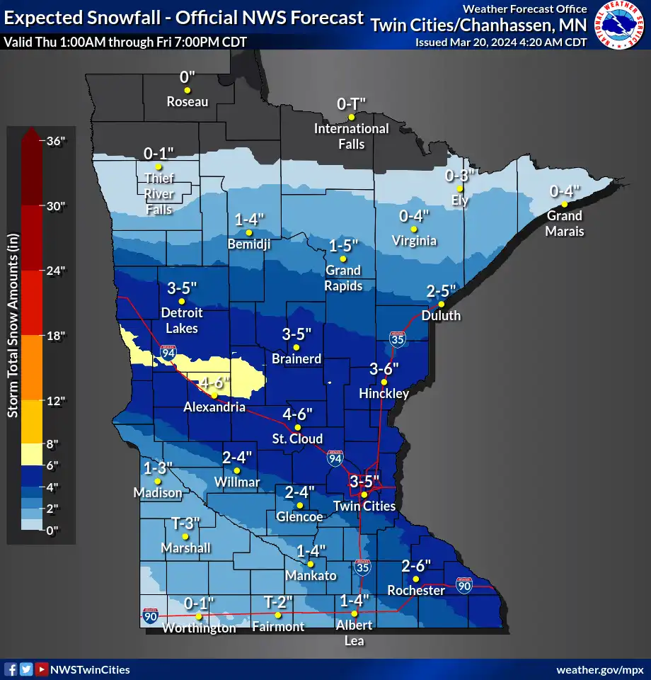
Two separate weather systems are expected to bring much-needed moisture to Minnesota, with the first system likely to bring 2-5 inches of snow from Thursday night into Friday morning, favoring the northern Twin Cities. The second system from Sunday through Tuesday could bring heavy precipitation totals of 1-3 inches, with the potential for a snow-to-rain transition, especially in southern Minnesota. This comes as a relief for the state, where about 75 percent is currently experiencing drought conditions.

weather2 years ago

Christmas Travel Forecast: Stormy Weather Ahead for US Cities

A pair of weather systems are expected to bring rain and snow to the central and western states before Christmas, and then impact the East Coast after Christmas. The Transportation Security Administration predicts that the busiest days for air travel will be Thursday, Friday, and New Year's Day, with over 2.5 million travelers daily. Transportation Secretary Pete Buttigieg warns of weather-related travel challenges in the coming weeks. AAA estimates that more than 115 million people will travel at least 50 miles for Christmas and New Year's Eve. Gas prices have decreased compared to last month and last year. Winter officially begins on Thursday, which is also the shortest day of the year.

climate-change2 years ago

"Climate Change Accelerates Jet Stream Speed, Study Reveals"

A study published in Nature Climate Change reveals that as climate change progresses, the fastest upper-level jet stream winds will accelerate by about 2% for every degree Celsius of warming, surpassing the average wind speed by 2.5 times. This increase in wind speed is expected to lead to decreased flight times, increased clear-air turbulence, and a potential rise in severe weather events. The research highlights the need for policymakers to address the impact of climate change on jet streams and plan for the future.

weather2 years ago

"Hurricane Lee's Uncertain Path and Potential Impact on the US East Coast"

Hurricane Lee, currently a Category 3 storm, is approaching the U.S. coastline, causing concern for millions of people. However, there is a good chance that Lee will not make a direct impact on the East Coast. The National Hurricane Center's forecast shows that Lee is expected to turn northward parallel to the coast, still well offshore. The exact path of the storm is uncertain and will depend on the interactions between various weather systems. While Florida is likely to be spared from direct impacts, the northeastern U.S. and Canada should remain alert and monitor the forecast. Rip currents are a significant risk along the East Coast. Advanced forecast models indicate that Lee will turn north, but the exact track could vary slightly. It is too early to determine the potential impacts on New England, but if Lee were to make landfall, storm surge would be a significant threat.

weather2 years ago

Atlantic Tropical Update: Caribbean-Bound System Draws Attention as Gert and Katia Linger

The National Hurricane Center is monitoring a system in the Atlantic that could potentially become the next tropical depression or storm and reach the Caribbean by next weekend. Another weather system off the coast of Africa is also being tracked for potential development. Meanwhile, Tropical Storm Gert is expected to dissipate soon, while Tropical Storm Katia is gradually weakening and is forecasted to become a remnant low. Neither Gert nor Katia pose a threat to land.

natural-disasters2 years ago

Unveiling the Science and Solutions of Wildfires and Carbon Emissions

The rapid spread of wildfires in Hawaii, which have killed at least 36 people and destroyed much of the town of Lahaina, can be attributed to a combination of factors. Months of drought and the presence of nonnative grasses made the vegetation highly flammable. However, it was the confluence of two weather systems - high pressure to the north and Hurricane Dora to the south - that created strong winds, with gusts as high as 82 mph, which rapidly spread the fires. These winds, known as downslope winds, compressed and heated the air, making it even drier and increasing the risk of wildfires. While Hurricane Dora passed farther away from Hawaii compared to previous incidents, it still played a role in fanning the flames.