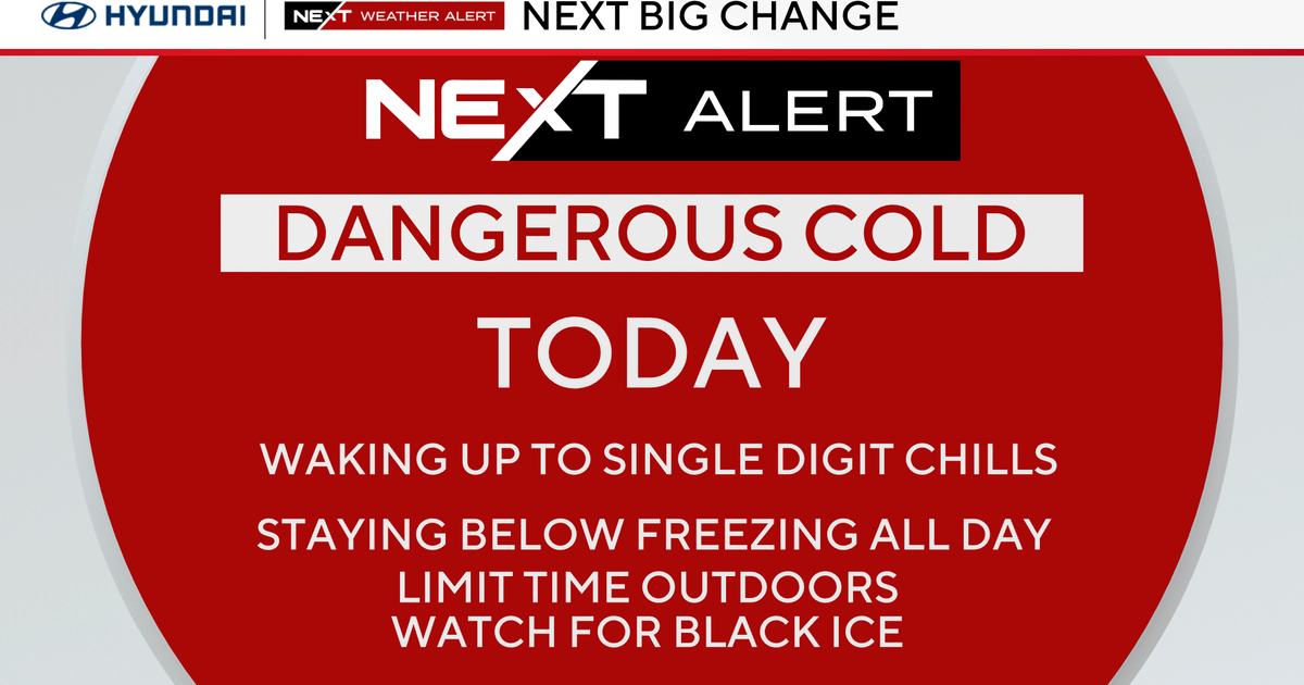
A storm is expected to bring freezing rain and icy conditions to parts of Massachusetts overnight Sunday, especially outside of Boston, with temperatures rising into the 30s and 40s during the day. The weather will improve by Monday with milder temperatures and rain, but gusty winds and cold temperatures will return afterward, continuing into the week.
Acting Governor Tahesha Way of New Jersey declared a State of Emergency due to a severe winter storm bringing heavy snow, sleet, and freezing rain, with snow accumulations of 5 to 8 inches expected, urging residents to avoid travel and stay updated on weather conditions.
A weather alert has been issued for Massachusetts, predicting snow showers from Friday night into Saturday morning, especially affecting southern areas, with potential for plowable snow and impacts on holiday travel. A fast-moving clipper will bring light, fluffy snow starting between 7-8 p.m., with coastal areas experiencing snow closer to midnight and into early Saturday morning. Another storm system is expected to bring snow, freezing rain, and then rain into early next week, followed by Arctic cold to end 2025 and start 2026.
A 4Warn Weather Alert has been issued for Metro Detroit from Thursday night to Friday morning due to expected rain turning to snow and a sharp drop in temperatures, which could cause icy road conditions and hazardous travel. The forecast includes scattered showers, strong winds, a potential flash freeze, and light snow accumulation, emphasizing caution for commuters.
A weather alert has been issued for the Twin Cities due to a complex storm bringing rain changing to snow, gusty winds up to 45 mph, and a flash freeze, leading to icy roads and potential travel disruptions. Temperatures will drop significantly, with snow showers expected later in the day and blizzard conditions in northwestern Minnesota, followed by a cold start to Friday and a gradual warming trend into the weekend.
The Philadelphia region experienced a snowstorm followed by a prolonged cold snap, with 18 consecutive days of below-average temperatures, which will continue until Thursday when temperatures are expected to rise into the 50s. The upcoming week will see gradually warming temperatures, with rain expected on Friday.
A winter storm is expected to hit Massachusetts and the Boston area on Tuesday, bringing light to heavy snow with the highest accumulations in central and western regions, and causing deteriorating travel conditions throughout the day. The storm will not be a major nor'easter and is unlikely to cause significant coastal issues or outages. Cold temperatures are also forecasted later in the week.
The National Weather Service has issued a winter storm watch for Northeast Ohio, predicting 5 to 10 inches of snow from Sunday evening to Tuesday morning, which could impact travel and cause power outages due to wet, heavy snow and falling leaves.
A deadly storm caused record rainfall in NYC, with Central Park experiencing its highest in over 100 years, leading to severe flooding, fatalities, and disruptions at airports and transit systems. The city is actively managing flood risks through pre-storm preparations and infrastructure efforts, while the weather remains windy and cool for upcoming events like Halloween and the NYC Marathon.
China and the Philippines are bracing for Typhoon Ragasa, one of the strongest in years, leading to evacuations, school and flight cancellations, and preparations for flooding and landslides, with significant impacts in both countries.
A severe thunderstorm watch is in effect for parts of Massachusetts and surrounding states until 8 p.m., with the potential for damaging winds, hail, and tornadoes, especially in inland areas like Central and Western Massachusetts. Residents are advised to stay weather aware as storms are expected to weaken after sunset, with some areas experiencing severe weather including tornado warnings and hail.
The Midwest faces a dual threat of flash flooding from heavy rains and thunderstorms, along with extreme heat warnings affecting over 50 million people, with conditions expected to worsen in the coming days.
Cathay Pacific canceled and delayed flights in Hong Kong as Typhoon Wipha approached, prompting the issuance of the second-highest storm signal and suspension of school activities, with full flight recovery expected in one to two days.
A powerful weather system is approaching Australia's east coast, bringing heavy rain, strong winds up to 100 km/h, and flood risks, particularly affecting New South Wales and Victoria, with conditions expected to ease by late Thursday. Other regions like Queensland, South Australia, Tasmania, Western Australia, and the Northern Territory will experience varying weather patterns, mostly calmer or less affected by this system.