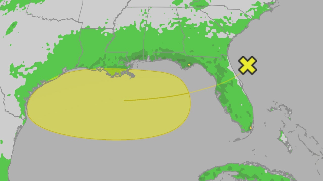
A tropical disturbance is expected to bring heavy rain and potential thunderstorms to Florida and the northern Gulf Coast over the next few days, with a small chance of developing into a tropical depression, while also increasing rip current risks at beaches.
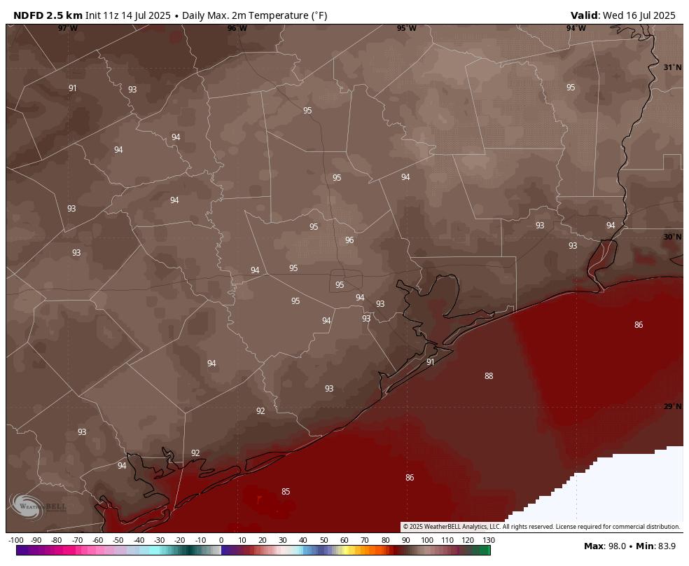
Houston is expected to experience warmer than normal conditions for the rest of July, with temperatures mostly in the mid-90s and a higher likelihood of rain due to tropical moisture, while a potential tropical disturbance may develop in the Gulf of Mexico, primarily affecting Louisiana.
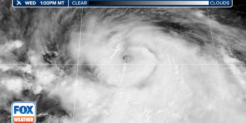
The National Hurricane Center is monitoring a disturbance in the southwest Atlantic with a 10% chance of developing into a tropical or subtropical system as it moves northeastward through the weekend. This comes just days before the official start of the 2024 Atlantic hurricane season, which NOAA predicts will be very active with 17-25 named storms.
A weak low-pressure system has formed east of the Bahamas and north of the Dominican Republic, with hostile upper-level winds limiting its potential for development into a significant storm. The National Hurricane Center gives the disturbance a 70% chance of becoming at least a tropical depression before the strong upper-level winds become prohibitive. The system is not expected to pose a threat to land and is likely to be swept up by a cold front moving off the East Coast. There is also a slight chance of another system forming in the Caribbean later in the week.
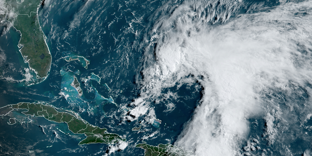
Tropical Disturbance Invest 94L, currently a large area of low pressure with disorganized thunderstorms, is expected to develop into at least a tropical depression this week as it moves towards the northeastern Caribbean islands. The strength of the system will determine its track, with a weaker system more likely to directly affect the islands and a stronger system potentially turning north. The latest computer forecasts favor a weaker system, but confidence in any one forecast is low until an organized system forms. There is no threat to the U.S. or surrounding areas, as a cold front will block any westward path. Tropical Depression Sean is dissipating in the central Atlantic, while a broad area of low pressure over Central America is expected to gain strength in the coming weeks.
Hurricane Nigel is rapidly strengthening in the Atlantic, with a forecast to reach Category 3, but it is expected to stay comfortably east of Bermuda. Meanwhile, a non-tropical low-pressure system is predicted to form off the east coast of Central or North Florida, potentially developing into a subtropical storm. The system's track is uncertain, but it could bring rain and gusty winds to the coastline. Additionally, a disturbance off the African coast has a high chance of developing into a tropical depression over the Atlantic later this week, although it is not currently a threat to land.
Invest 95L, a tropical disturbance off the coast of western Africa, is being monitored for potential development into a tropical depression, storm, or hurricane. While long-range forecast models suggest it could impact the Caribbean or western parts of the Atlantic, it is still too early to determine its exact track. The National Hurricane Center has given it a 40% chance of developing into a tropical depression within the next 48 hours and an 80% chance within the next week.
Sunday will be less humid with partly to mostly sunny skies and highs in the mid to upper 80s. The midweek period will have a good amount of sunshine with highs in the mid 80s. Storm chances will increase later in the week, and there is a tropical disturbance in the central Atlantic with a high chance of development.
Hurricane Adrian has formed off the coast of Mexico in the Eastern Pacific, becoming the first hurricane of the season. Another tropical disturbance is expected to develop behind Adrian, potentially becoming the second named storm of the season. The Eastern Pacific is running slightly behind schedule for hurricane formation, which is unusual for an El Niño year. Adrian is forecasted to slowly move westward and strengthen over the next few days, potentially reaching winds of at least 90 mph. Meanwhile, the National Hurricane Center is also tracking a tropical disturbance south of Guatemala and Mexico, with a high chance of development into a tropical depression.
The Gulf Coast is expected to experience several more days of active weather with a risk of severe thunderstorms and flooding. A tropical disturbance located far away from the United States in the Atlantic Ocean could develop into a tropical depression by early to middle next week. Dangerous surf and a high risk of rip currents will persist for the next few days at area beaches.
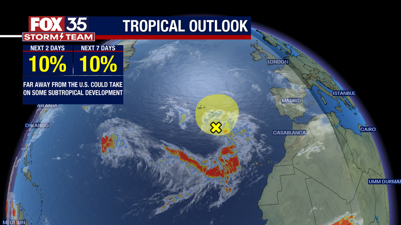
The National Hurricane Center is monitoring a new tropical disturbance in the northeastern Atlantic Ocean, which is producing disorganized showers and thunderstorms between the Azores and Canary Islands associated with a complex non-tropical area of low pressure. The disturbance has a low chance – 10% – of developing into a tropical system over the next couple of days. Hurricane season runs through Nov. 30.
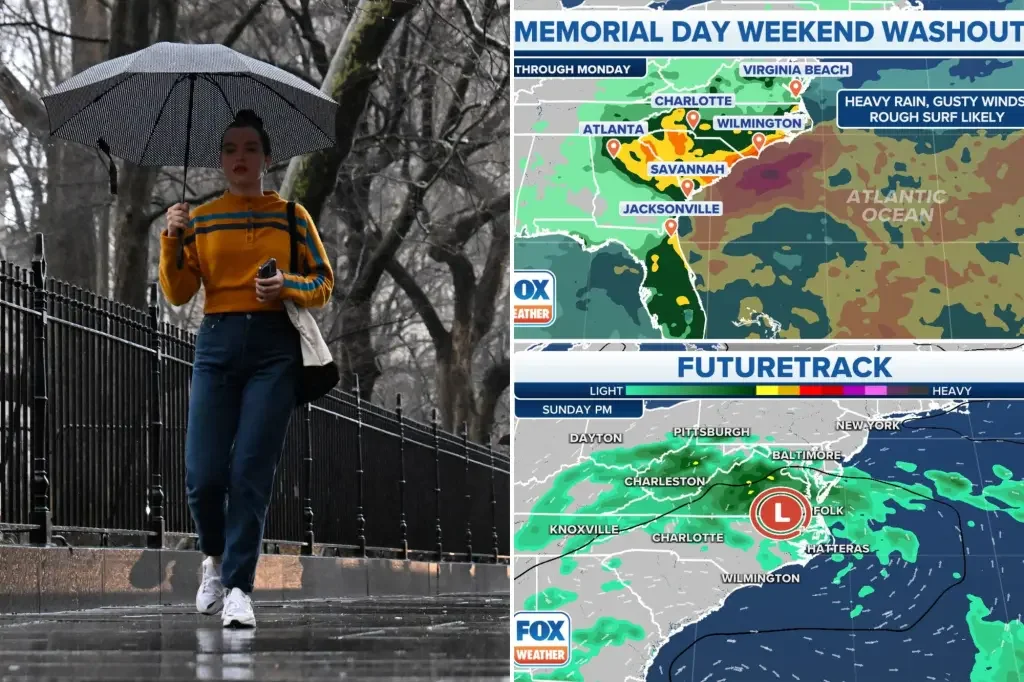
Heavy rain, gusty winds, and rough surf are expected for parts of the East Coast for the Memorial Day weekend, potentially ruining travel plans for millions vacationing during the unofficial start to summer. A tropical disturbance developing over the western Atlantic could cause a holiday weekend washout for parts of the Carolinas and the Southeast coast. Regardless of tropical development, a period of heavy rain, rough surf, and gusty winds will impact coastal regions of the Southeast later this week and into the Memorial Day weekend. More than 42.3 million Americans will travel 50 miles or more from home this weekend. A large ridge of high pressure over the Northeast is going to deliver the saving grace this weekend for those there, keeping the forecast dry north of Washington, D.C.
Forecasters at the National Hurricane Center are monitoring a tropical disturbance near the Bahamas, which has a low chance of developing into a storm. However, the overall atmospheric pattern over the southeastern US will remain unsettled over the next few days and into the Memorial Day weekend, with stormy weather expected even if a tropical or subtropical storm does not develop. "Preseason" storms are not rare, with 19 storms forming before the official start of the Atlantic hurricane season over the past 50 years.
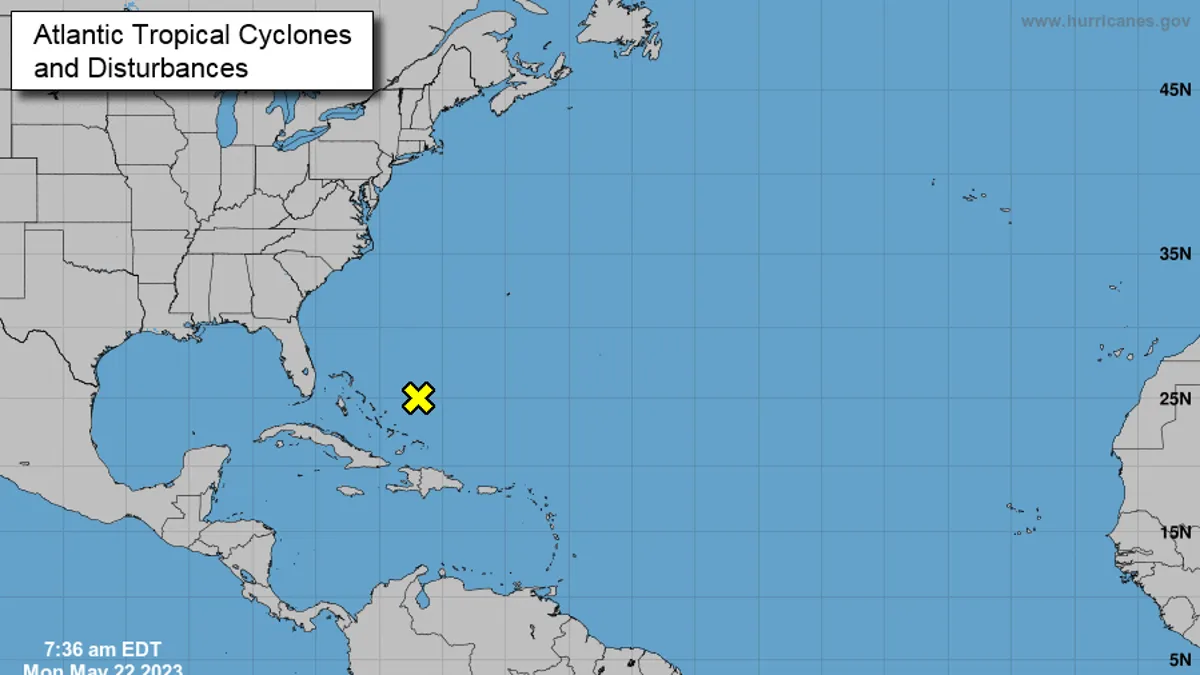
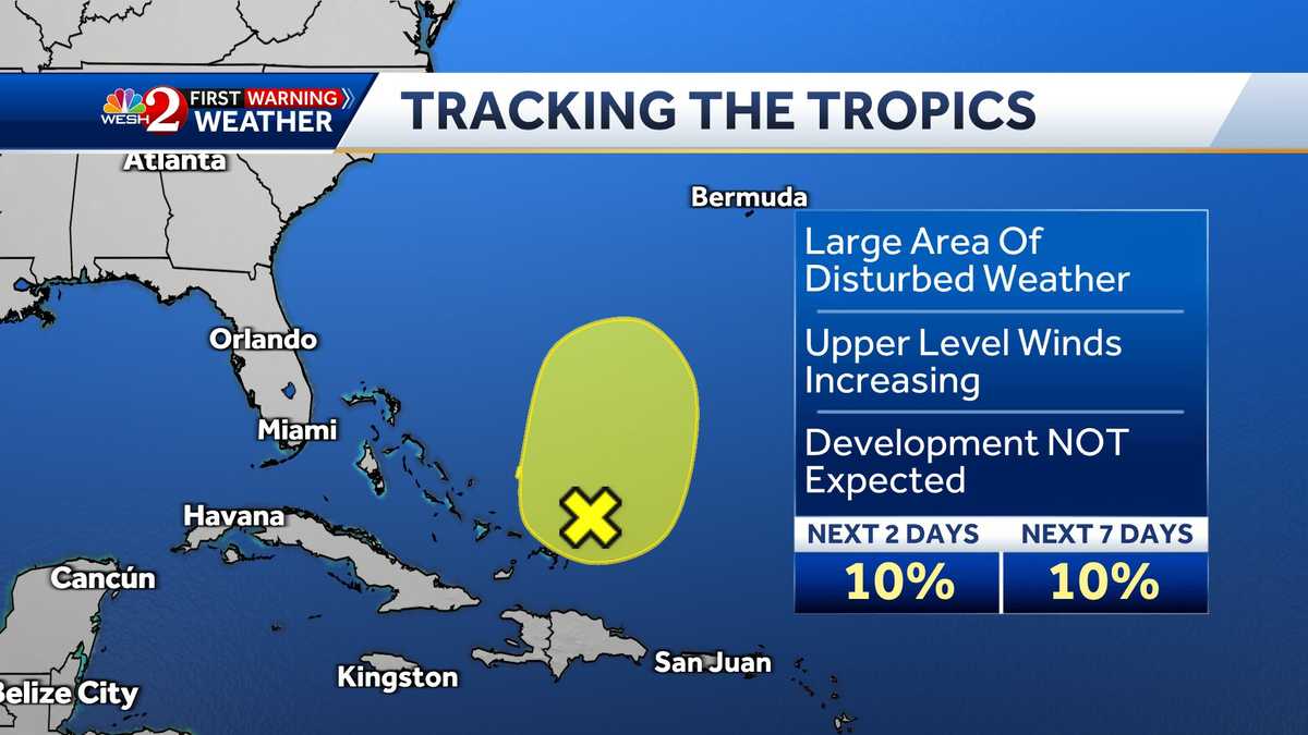
The National Hurricane Center has identified a large area of disturbed weather in the Atlantic Ocean, marking the "first area of interest" this hurricane season. The system is poorly organized and located a couple of hundred miles northeast of the central Bahamas. Strong upper-level winds and dry air are expected to prevent development while the system moves generally north-northeastward at 5 to 10 mph over the southwestern Atlantic during the next couple of days. There is a 10% chance of development over the next few days, but the disturbance is unlikely to form.
The National Hurricane Center is monitoring a tropical disturbance northeast of the Bahamas, with a 10% chance of formation over the next 48 hours and over the next seven days. Meanwhile, Colorado State University predicts a slightly below average Atlantic hurricane season with 13 named storms, six hurricanes, and two major hurricanes. Central Florida will see higher rain chances on Monday and Tuesday, with an isolated severe storm or two on Monday afternoon.