A major winter storm is forecast to lash the U.S. South and East Coast this weekend, bringing heavy snow and ice, travel delays and flight disruptions, with officials warning of potential power outages and urging residents to prepare for the storm.
The National Hurricane Center warns of a storm forming near the Southeast, potentially stalling offshore of the Carolinas early next week, bringing heavy rain, damaging winds, and large waves to coastal areas.
Strong thunderstorms and heavy rainfall are expected to impact the Midwest and Southeast this weekend, with risks of flash flooding and damaging winds, while the Southwest faces record-breaking heat with temperatures exceeding 110°F in some areas.
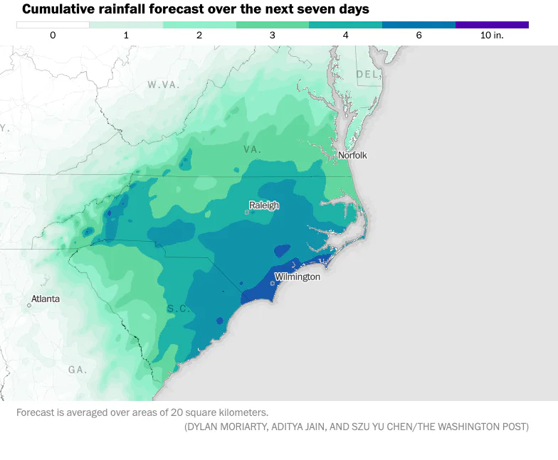
A powerful cold front combined with tropical moisture is causing heavy rains and flash flood risks across the Southeast, particularly in the Carolinas and Georgia, with potential for isolated 3-5 inch rainfall amounts, and the threat of tropical development remains low but possible.
Severe storms have caused tornadoes and life-threatening flooding in the Gulf Coast, with one reported death in Mississippi. The storms are now moving into the Southeast and Ohio Valley, bringing a risk of severe thunderstorms, damaging winds, and drenching rain. Over 30 million people are under wind advisories, and more than 260,000 are without power from Texas to Georgia. The storm system is expected to lose potency on Thursday, but there is still a risk of flooding in parts of northern New England as the storms shift through the Great Lakes and interior Northeast.
Flash flooding hit Tallahassee, Florida, as severe storms shifted to the Southeast and Ohio Valley, prompting a Flash Flood Emergency and causing road closures, power outages, and inoperable traffic signals. The storm system is expected to bring significant showers and thunderstorms with the potential for hail, damaging winds, and tornadoes in the Southeast and Ohio Valley. The National Weather Service issued Tornado Watches for parts of Florida and Georgia, while the upper Ohio Valley faces a Level 3 out of 5 risk of severe storms. The stormy weather is expected to persist, potentially aggravating cleanup efforts in areas already affected by flooding.
One person is dead and three individuals are in custody following a homicide in southeast Albuquerque. The incident occurred on Sunday afternoon, and the victim was taken to the hospital but later pronounced dead. Further details have not yet been released as the police continue their investigation.
A "cicada-geddon" is set to occur in the Southeastern United States as two groups of cicadas, including the largest geographic brood in the nation, are emerging this spring. These insects, which appear every 13 and 17 years, are set to cover the landscape in trillions, possibly quadrillions, and are a unique sight to behold. While they don't harm people or pets, they can pose a threat to young trees. The early emergence of these cicadas is attributed to climate change, and experts advise against killing them, suggesting protective measures for young trees instead.
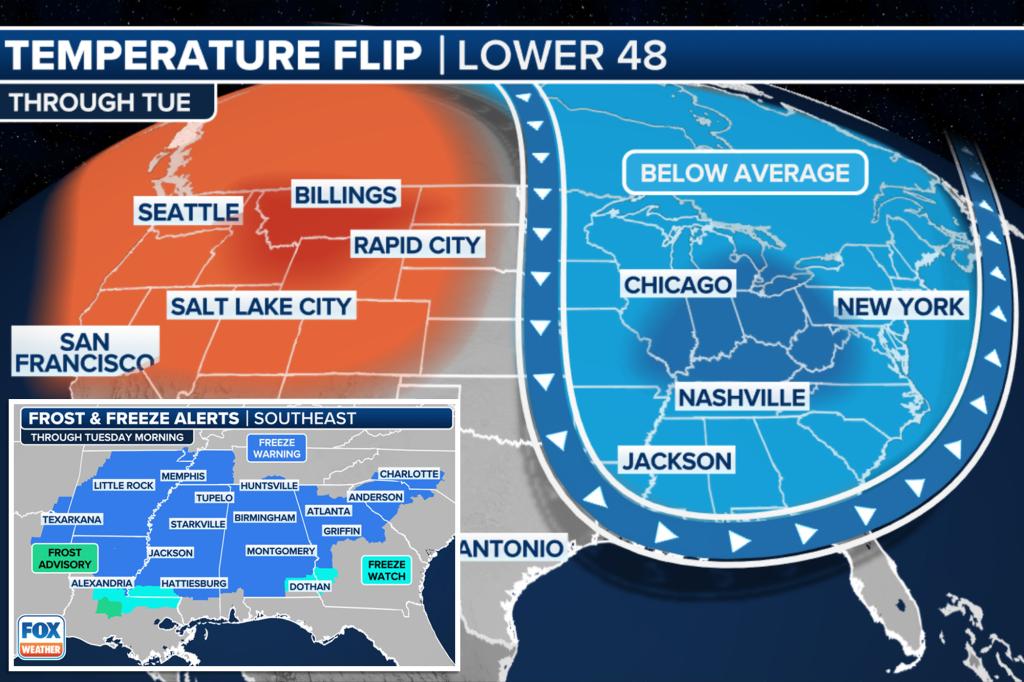
Tens of millions of people in the eastern U.S. are facing winterlike temperatures as cold air from Canada brings freezing conditions, with a risk of snow squalls and lake-effect snow in the Great Lakes and Northeast. More than 25 million people in the South and Southeast are urged to protect plants and crops as temperatures plunge below freezing, while the Midwest and Northeast also experience below-average temperatures. Despite the cold snap, temperatures are expected to gradually warm up as we move into the middle of the week.
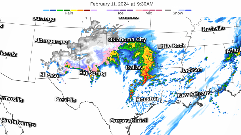
The National Weather Service forecasts heavy rain and potential severe weather in the Lower Mississippi Valley, Gulf states, and Southeast, with concerns of flooding and tornadoes. Tennessee faces strong downpours, thunderstorms, and overnight flash flooding, while Alabama may experience tornadoes and wind gusts. The Ohio Valley to New England is expected to see heavy rain, strong wind gusts, and potential wet snow, leading to power outages, slippery travel conditions, and renewed river flooding.
Southeast Michigan is in for a turbulent weather week, with meteorologists predicting record high temperatures, hail, tornadoes, and possible 60 mph winds. The region will experience a rollercoaster of weather systems, transitioning from spring-like highs to plummeting temperatures and even a chance of snow. Residents are advised to stay alert for severe storms and be prepared to take shelter if necessary.
Severe thunderstorms are expected to hit the central Gulf Coast and spread into the Southeast, bringing hail, tornadoes, and heavy rainfall, with a risk of flash flooding. Meanwhile, a snowstorm is set to sweep into the Northeast, potentially dropping over a foot of snow and causing travel disruptions. About 23 million people are at risk of severe weather in the Southeast, while 20 million people are under winter storm warnings or watches in the Northeast.
Severe thunderstorms are expected to hit the central Gulf Coast and Southeast, bringing hail, tornadoes, and heavy rainfall, with a risk of flash flooding. Meanwhile, a winter storm is set to move from the Rockies into the Northeast, potentially causing heavy snow and travel disruptions, with winter storm watches in place for about 20 million people. New York City could see 1-2 inches of snow, while parts of the Northeast may receive 6-8 inches, with higher amounts in mountainous areas. Powerful winds and wet snow could lead to power outages and hazardous travel conditions, prompting warnings from officials to stay updated on the weather forecast.
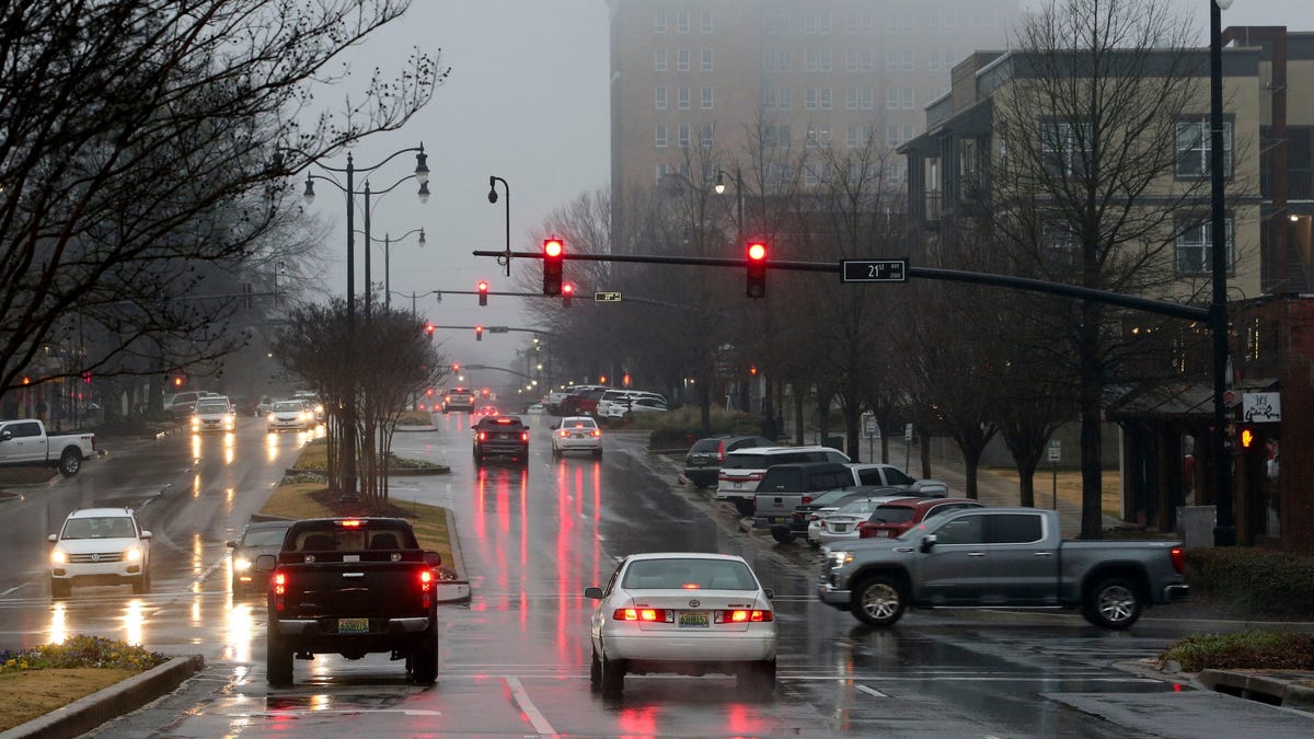
Nearly 100 million people are under dense fog advisories as downpours persist in the Southeast, leading to flash flooding and minor to moderate river flooding. The National Weather Service warns of life-threatening floods in the central Gulf Coast states and forecasts excessive rainfall in Mississippi and Louisiana, with flood warnings in effect for parts of Tennessee. Meanwhile, the western U.S. faces widespread low elevation rain and mountain snow due to a cold front.
A multi-day wet weather event is expected to bring the heaviest precipitation of the year to the Gulf Coast and Southeast, with 3-5 inches of rain and isolated areas seeing more. The warm weather pattern will lead to multiple waves of moisture impacting the region, with the potential for flash flooding and excessive rainfall. Temperatures are expected to moderate through the week, with highs reaching the 60s and 70s for many areas.