Tag

Satelliteimagery

All articles tagged with #satelliteimagery

"NASA Discovers Unusual Phenomenon in Russian Eastern Skies"
science-and-environment2 years ago

"NASA Discovers Unusual Phenomenon in Russian Eastern Skies"

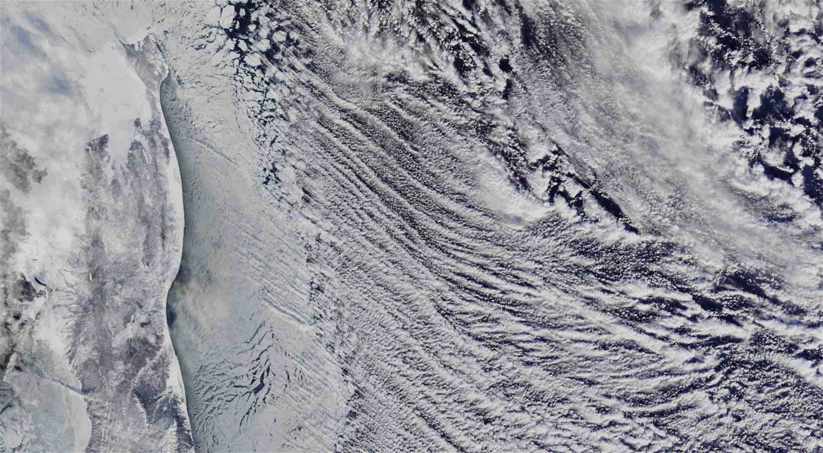
NASA's Terra satellite, equipped with the MODIS instrument, captured striking images of parallel cloud formations known as "cloud streets" off the eastern coast of Russia. These formations occur when cool, dry air moves over warmer waters, leading to vapor condensation and cloud formation. The phenomenon was observed alongside anomalously low temperatures in the region, as reported by NASA's Global Modeling and Assimilation Office (GMAO). The cloud streets and the associated low temperatures are part of ongoing research to understand Earth's climate and atmospheric conditions.

"China Constructs Full-Scale USS Ford Replica for Military Drills"
military-and-defense2 years ago

"China Constructs Full-Scale USS Ford Replica for Military Drills"

Satellite images have revealed a mock-up of the US Navy's USS Gerald R. Ford aircraft carrier in the Taklamakan Desert, China, which is presumed to be used for target practice to test China's missile capabilities. The images, captured by Planet Labs, show detailed replicas of the Ford-class carrier and an Arleigh Burke-class destroyer, indicating China's focus on enhancing its ability to counter US naval forces. The construction of these models aligns with China's reported increase in missile stockpiles, including the DF-26 intermediate-range ballistic missiles, known as "carrier killers." This development reflects ongoing tensions and the strategic military focus in the Indo-Pacific region.

"Study Shows Major US East Coast Cities Including NYC and DC Sinking Rapidly"
science-and-environment2 years ago

"Study Shows Major US East Coast Cities Including NYC and DC Sinking Rapidly"

Satellite imagery has revealed significant subsidence, or land sinking, across major cities on the U.S. East Coast, with some areas sinking as much as 5 millimeters per year. This phenomenon poses a threat to infrastructure, including buildings, roads, and airports, and exacerbates flood risks when combined with sea-level rise due to climate change. The research, conducted by Virginia Tech and the USGS, highlights the urgency of addressing subsidence in densely populated and infrastructure-heavy areas to mitigate potential damage and increased flood risks.

"AI and Satellite Data Unveil the Hidden Congestion and Illegal Activities of Ocean Vessels"
environment-and-technology2 years ago

"AI and Satellite Data Unveil the Hidden Congestion and Illegal Activities of Ocean Vessels"

A new study utilizing satellite imagery has revealed extensive illegal fishing activities by the 'Ghost Fleet,' which accounts for 75% of the fish industry's unmonitored and unregulated operations. This breakthrough in mapping industrial activities at sea from 2017 to 2021 highlights the challenges in tracking maritime activities due to limited vessel-tracking systems and the lack of mandatory tracking devices on all vessels. The findings are significant given the ocean's vital role in global trade, food supply for over a billion people, and employment for 260 million in the marine fisheries sector.

"New Maps and Studies Expose the Vast 'Dark Fleet' of Industrial Activity in Crowded Oceans"
environment-and-technology2 years ago

"New Maps and Studies Expose the Vast 'Dark Fleet' of Industrial Activity in Crowded Oceans"

A study by Global Fishing Watch, published in Nature, utilized satellite imagery and machine learning to reveal that a significant portion of the global fishing industry operates outside of public tracking systems, with about three-fourths of industrial fishing vessels and nearly a third of transport and energy vessels not publicly tracked. The analysis of two petabytes of orbital imagery from 2017-2021 showed a substantial underrepresentation of Asian fishing activities in public data, with satellite data indicating that Asia, particularly China, accounts for a much larger share of global fishing than previously thought. This research highlights the need for better tracking and data sharing to inform policy and protect marine resources, including efforts to monitor fishing in protected areas like the Galapagos Islands.

"New Studies Expose the Hidden Industrial Boom and Untracked Fishing Threatening Ocean Health"
environment-and-science2 years ago

"New Studies Expose the Hidden Industrial Boom and Untracked Fishing Threatening Ocean Health"

Researchers from Global Fishing Watch have utilized satellite imagery and AI to create detailed maps of human activity at sea, revealing extensive industrial activity that was previously undetected. The study found that 75% of the world's industrial fishing vessels are not publicly tracked, with significant activity around Africa and South Asia. The maps also showed a surge in offshore energy development, particularly wind turbines in Europe and China. This new data is critical for global conservation efforts, especially as nearly every nation has committed to protecting 30% of Earth's land and waters by 2030. The research underscores the need for better management of maritime resources to prevent overexploitation and preserve biodiversity.

"Japan's Recent Disasters: Lessons in Earthquake Response and Aviation Safety"
world-news2 years ago

"Japan's Recent Disasters: Lessons in Earthquake Response and Aviation Safety"

A devastating 7.6-magnitude earthquake struck Japan, causing significant destruction and fatalities. Satellite images reveal extensive damage along the west coast and in cities like Suzu and Wajima, with visible capsized boats, destroyed buildings, and large ground fissures. The quake triggered tsunami warnings and aftershocks, leaving thousands without power and at least 62 people dead. Rescue efforts are ongoing as teams search for survivors amidst the rubble.