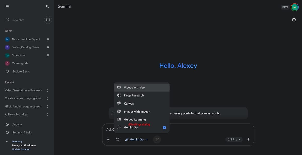
Google is testing new experimental modes within Gemini, including Agent Mode for autonomous task execution, Gemini Go for collaborative idea exploration, and Immersive View for visual answers, indicating a shift towards a more autonomous and creative platform.
Google has provided an inside look at the technology behind its Immersive View feature for Google Maps, showcasing the evolution of its Street View camera technology and the methods used to capture imagery worldwide. Immersive View offers a three-dimensional rendering of destinations, allowing users to see weather forecasts, traffic conditions, and detailed surroundings. It combines footage from Street View with images from a 3D aerial camera, utilizing AI and computer vision to create realistic digital models. Two versions of Immersive View are available, with the route preview option rolling out in select cities.
Google is introducing generative AI to Google Maps, allowing users to make specific requests such as "places with a vintage vibe in SF" and receive tailored suggestions based on Maps' rich information. The AI will organize results into categories and provide review summaries for each location. This feature is currently rolling out to select Local Guides in the US before becoming more widely available. Additionally, Google has begun rolling out Immersive View for Google Maps, providing a bird’s-eye view of routes with 3D imagery for easier navigation.
Google Maps is receiving a significant AI upgrade with five new features. These include Immersive View, which provides a 3D street-level view of routes and surroundings, and Google Maps Search, which uses AI to offer personalized location suggestions. The AI enhancements also improve lane guidance and traffic information in Google Maps Navigation, and provide more information on EV charging stations. Additionally, the app's AR feature, now called "Lens in Maps," uses AI to recognize and label objects and places in the camera view, overlaying information and directions using augmented reality. However, users should be aware of the amount of personal data collected by Google Maps.
Google Maps has unveiled new AI-powered features, including Immersive View for routes that provides a 3D view of your journey and allows you to explore places before visiting, and Google Lens in Maps that uses AI and augmented reality to help you navigate and find nearby amenities. The update also includes more realistic navigation details, improved lane details, and information about HOV lanes and speed limits. For electric vehicle drivers, Google Maps now provides more information about charging stations, including compatibility and charging speed, and alerts users when a charger is out of service. Additionally, Google Maps offers a more visual and inspiring search experience with photo-based results and themed suggestions for activities and dining.
Google Maps is introducing new AI-powered features for iPhone users to enhance trip planning and navigation. The Immersive View for Routes feature allows users to preview their entire journey in a multidimensional view, offering detailed turn-by-turn directions and the ability to plan departure times based on simulated traffic and weather conditions. Another feature called Lens in Maps utilizes AI and augmented reality to help users acclimate to their surroundings by providing information about nearby amenities. Additionally, Google Maps will offer more lifelike representations of buildings and enhanced lane details for better orientation during navigation. The platform is also improving information for electric vehicle drivers, offering enhanced charging station details and indicating charger compatibility. Lastly, Google is enhancing search capabilities in Maps, providing visually oriented results and thematic search suggestions for activities and dining options.
Google Maps is introducing Immersive View for routes, which uses AI, Street View, and aerial images to provide a multidimensional experience for users to preview bike lanes, sidewalks, intersections, and parking along their journey. The update also includes a time slider to view air quality and weather changes, AI-driven traffic simulations, and improved navigation features. Additionally, Google Maps is replacing Search with Live View with Lens, offering AR-delivered information about nearby amenities. Other updates include enhanced map visuals, HOV lane information, speed limit data, and improved EV charging station details.
Google is introducing new AI-powered features to Google Maps, making it more like Google Search. These features include immersive navigation, improved driving directions, and better organized search results. Google wants Maps to be a place where users can not only get directions but also discover new places and experiences. The company is using AI to analyze user-uploaded photos and provide relevant search results based on real-time analysis. Additionally, Google Maps will now provide information on the availability and compatibility of EV charging stations. The company is also rolling out flashy features like Immersive View and rebranding its augmented reality feature as "Lens in Maps." Google aims to make Maps more visual, immersive, and helpful in making sustainable choices.
Google Maps' Immersive View feature is now available in four new European cities, including Amsterdam, Dublin, Florence, and Venice, as well as over 500 iconic landmarks worldwide. The feature was initially launched in cities such as New York City, San Francisco, London, and Tokyo. Google also announced updates to the trip-planning "Recents" feature and "glanceable directions" on the Google Maps web app.
Google Maps will roll out glanceable directions for walking, cycling, and driving modes on Android and iOS this month. Google's AI-powered immersive view is now available in four new cities and supports 500 iconic landmarks globally. Desktop users will have an update next month that saves places in their Recent highlights even after closing the Google Maps window.
Google Maps is introducing new features for navigation and discovery, including glanceable directions that allow users to track their trip progress from their lock screen or route overview, updates to Recents on desktop, and an expanded Immersive View that includes over 500 landmarks. The feature allows users to see what the weather will be like at different times of day and how crowded it will be, and peek inside restaurants and cafes to help plan ahead.
Google Maps has updated its Immersive View feature to include a multidimensional experience that allows users to see their upcoming route in 3D. The feature combines Street View and aerial images using AI to create 3D models of specific buildings and locations. The new feature will also provide real-time traffic forecasts, air quality information, and weather changes throughout the day. The feature will be rolled out in more than 15 cities, including New York, London, and Tokyo.
Google Maps is introducing "Immersive View for routes" which uses computer vision and AI to create a 3D rendering of a user's route to a location, allowing them to preview it before heading out. The feature will show weather, car accidents, and more, but cannot account for new information that happens en route. It will be available on mobile for 15 cities including San Francisco, New York City, and Paris in the next few months.
Google Maps is rolling out an update to Immersive View for Maps, adding a "multidimensional experience" for routes that allows users to preview bike lanes, sidewalks, intersections, and parking on their route. The app will use AI and historical driving trends to show users what traffic might look like depending on what time they'll be on the road. The update will also show air quality information and how weather changes the route throughout the day by using the time slider. The new update will be available in 15 cities in the coming months.
Google Maps has introduced a new feature called Immersive View for routes that allows users to preview their entire journey, including bike lanes, sidewalks, intersections, and parking, before setting off. The feature uses artificial intelligence to provide information like how many cars might be on the road, and is available for walking, cycling, or driving.