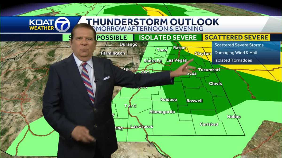
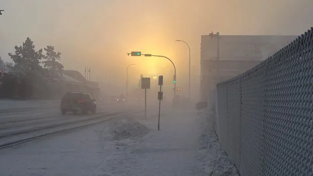
Yukon is experiencing an extreme cold snap with temperatures dropping to -50°C due to a high-pressure Arctic ridge, causing power grid stress and potential blackouts, with temperatures expected to gradually rise next week as the high-pressure system moves away.
Austin is forecasted to experience triple-digit temperatures this weekend, one of the earliest occurrences on record since 1898. A high pressure system over Mexico is pushing heat into Texas, potentially bringing heat indexes as high as 110°F. Meteorologists warn that early season heat waves can be more dangerous as people are not yet acclimatized. The trend of earlier and more frequent extreme heat is linked to climate change, with Austin seeing a significant increase in triple-digit days since 2000.
San Francisco is expected to experience warmer temperatures this week, with highs reaching the 80s due to a high-pressure system compressing the usual coastal breeze. The warmest days are anticipated to be Thursday and Friday, with temperatures dropping to the upper 50s to lower 60s overnight. The National Weather Service advises practicing heat safety, limiting outdoor activities during the afternoon, and seeking air-conditioned venues. Health experts warn of the risks of excessive heat exposure, including strokes and exhaustion. Cooler temperatures will return by Sunday and Monday.
New Mexico is experiencing a hot weekend with scattered showers and thunderstorms, but extreme heat is expected to move in next week. A high-pressure system centered in the southern part of the state is causing a heat advisory, which is likely to expand across much of New Mexico. Temperatures are expected to reach 100 degrees or higher for six consecutive days, making it one of the hottest stretches in years. Severe storms are also forecasted for eastern parts of the state.
The Bay Area experienced a heat wave over the weekend, with temperatures soaring to triple digits after a cool month. Some areas reached record highs, with Concord Airport hitting 105 degrees and Livermore Airport reaching 107 degrees. While no heat records were officially broken, temperatures are expected to remain above normal. A heat advisory is in effect, and people are advised to stay hydrated, avoid the sun, and check on vulnerable populations. The heat is unusual for this time of year, but by the Fourth of July, temperatures are expected to cool down.
A heat dome caused by a high-pressure system is keeping Texas hot and dry, with no relief in sight for at least another week. The National Weather Service has issued excessive heat warnings and advisories, urging residents to stay hydrated, stay indoors, and avoid strenuous activities during the hottest parts of the day. The heat dome is preventing clouds from forming, leading to clear skies and relentless sunshine. The weather service warns of the dangers of vehicular heatstroke and urges residents to know the signs of heat exhaustion and heat stroke.
Unusual, drastic temperature spikes called heat bursts have been witnessed in Central Texas due to hot temperatures and decaying evening thunderstorms. Heat bursts occur at the tail end of thunderstorms, but those are happening less often in Bexar County and South Texas lately. The chances of a heat burst in San Antonio largely depend on the formation of thunderstorms in the area, which is becoming a less likely event with each passing day. Meanwhile, South Texas continues to be roasted by triple-digit temperatures made even more oppressive by elevated humidity levels.
The National Weather Service has issued a tornado warning for south central Jeff Davis County until 4:15 p.m. A tornado watch is in effect for several counties until 7 p.m. Today is an impact weather day with a small threat for isolated severe thunderstorms from 1 pm-8 pm. The best chance for severe thunderstorms will be south of Savannah near the Altamaha River. High pressure-system will control the weather on Saturday, while Sunday will see scattered showers or thunderstorms as a cold front approaches the area. Next week is looking mainly dry and pleasant with highs in the 70s and low-80s.