Tag

Enhanced Risk

All articles tagged with #enhanced risk

weather1 year ago

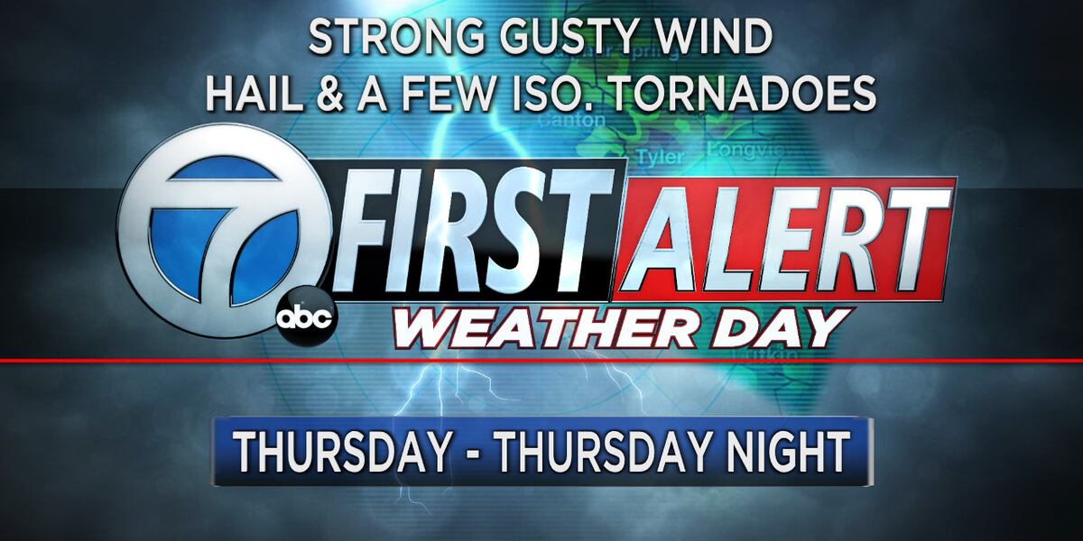
"Severe Weather Threat: Storms, Tornadoes, and Hail Forecast Across the US"

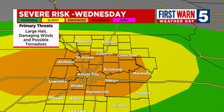
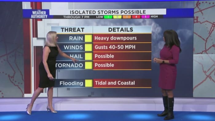
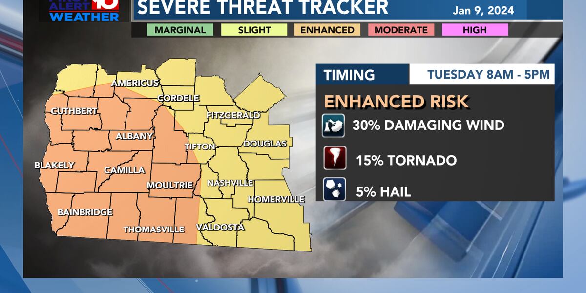
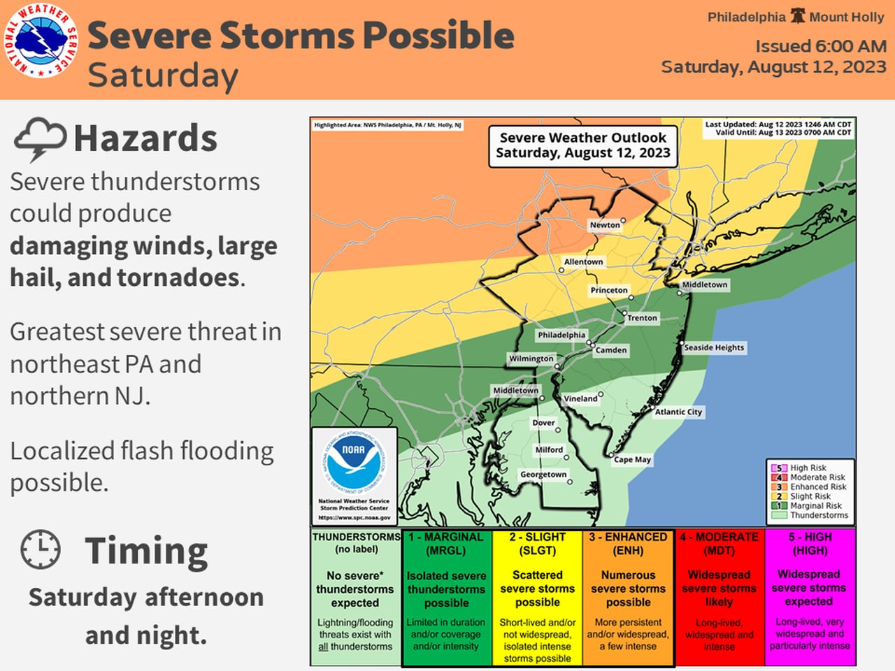
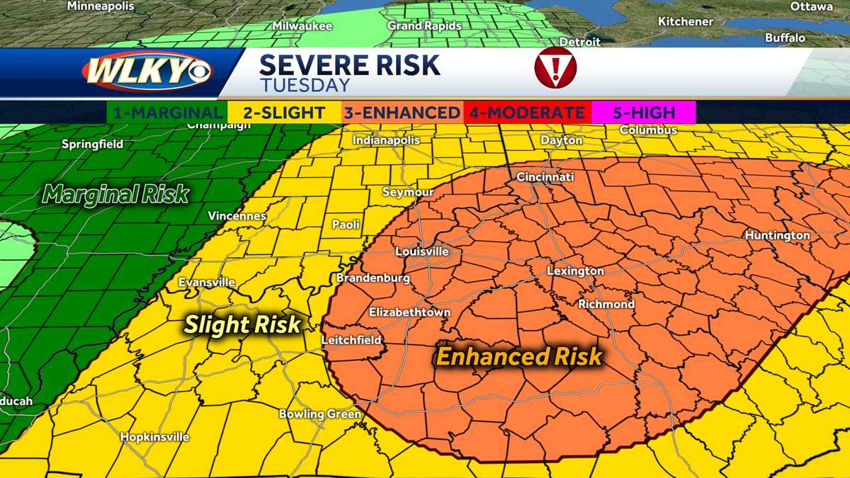
Breezy southerly winds, ample moisture, and warm temperatures will create an unstable air mass ahead of an approaching cold front early in the week, leading to scattered strong to severe storms on Monday and Tuesday. The Storm Prediction Center has issued a Severe Alert Day for both days, with Tuesday posing the greatest threat. Louisville area is under a Slight Risk for severe weather on Monday and an Enhanced Risk on Tuesday, with the potential for damaging winds, hail, and a potential tornado. Stay updated with WLKY for the latest forecast.

weather1 year ago

"Enhanced Risk for Severe Storms Prompts Alert Day in South and Plains"

A First Warn 5 Weather Day has been declared in Kansas City due to an enhanced risk for severe storms, with areas like Harrisonville, Marshall, Cameron, Atchison, Lawrence, and the Kansas City metro under a level 3 out of 5 risk. The threats include very large hail, damaging winds, and a few tornadoes, with significant hail of 2+ inches or larger expected.

weather2 years ago

"Georgia Braces for Severe Storms and Damaging Winds on Tuesday"

Tuesday's weather in Georgia is under an enhanced threat for severe storms, with isolated strong-to-severe storms bringing the potential for heavy downpours, tornadoes, and small hail from noon to sunset. Sustained winds of 20-35mph and gale conditions are expected, with minor coastal/tidal flooding in certain areas. Residents are advised to secure outdoor items and stay updated on the evolving weather conditions.

weather2 years ago

"Georgia Braces for Severe Weather Threat This Week"

Southwest Georgia is under an Enhanced Risk for severe thunderstorms on Monday night and Tuesday, with the potential for damaging winds, tornadoes, and large hail. The region may also experience heavy rainfall, leading to flash flooding and minor flooding in river basins. Residents are advised to prepare for the severe weather event and ensure they have multiple ways to receive warnings.

weather2 years ago

Musikfest 2023: Final Days Packed with Music and More

The Lehigh Valley is under a "slight risk" for severe weather on Saturday, with northern communities near the Kittatinny Ridge facing an "enhanced risk." The stormy weather is expected in two waves, potentially producing severe storms with large hail, damaging winds, and heavy rain. The National Weather Service warns of the possibility of tornadoes and localized flash flooding. Sunday is forecasted to be mostly sunny, with precipitation returning on Monday night.

weather2 years ago

Unsettled Weekend Weather: Quiet Evening, Stormy Sunday, and Showers through Monday.

Sunday is a 9 First Warning Weather Alert Day for the Tri-State area, with an Enhanced Risk for severe storms including damaging wind gusts, hail up to 2 inches, and isolated tornadoes. The timing of the storms will depend on the morning rain, but the greatest threat is expected to develop around 5 or 6 p.m. and last until 10 p.m. or so. Monday will bring more rain, but nothing strong or severe is expected.

severe-weather2 years ago

Alabama's Severe Weather Alert: Tornado Watch and Cancellations.

The Severe Thunderstorm Watch for Barbour and Pike counties has been cancelled, but an Areal Flood Watch goes into effect starting tonight at 9 pm for several counties in Central Alabama until 7 am Monday morning. An Enhanced Risk is up for locations along and south of a line from Tuscaloosa to Troy to Dothan, and a Slight Risk is up for much of the rest of the state, except for the northeastern parts of the state. A tornado risk has been added to the severe threats for tonight, especially for the western half of the area.

weather2 years ago

Severe weather threat looms over Texas on Thursday.

East Texas is under a First Alert Weather Day for Thursday due to the likelihood of two rounds of strong/severe thunderstorms, with the greatest risk being strong/gusty thunderstorm winds of 70 mph or more. The northern half of East Texas is under an ENHANCED RISK, while the southern half is under a SLIGHT RISK in the risk category. Flash flooding is possible with rainfall totals of up to three inches in some areas. Residents are advised to stay weather alert and sign up for First Alert-ThunderCall.