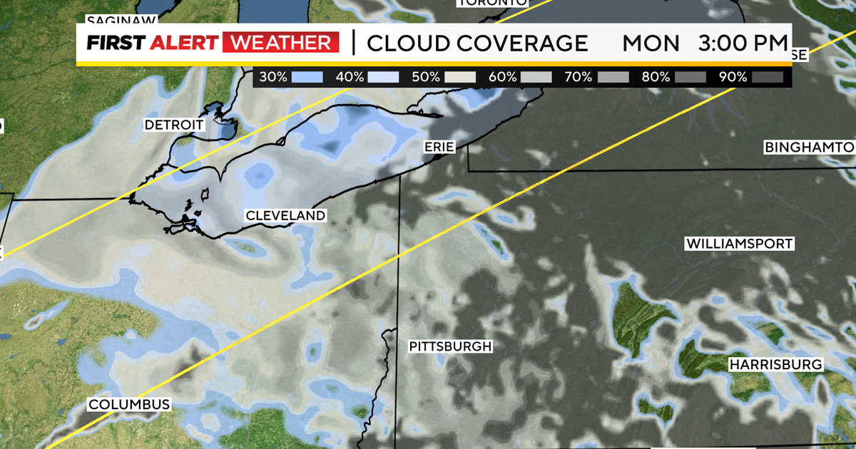
Cloudy skies are expected for the partial solar eclipse in Pittsburgh today, with the eclipse reaching 97% totality at 3:17 p.m. Temperatures are forecasted to drop as the moon passes between the Earth and the sun, casting a shadow and partially blocking the sun.
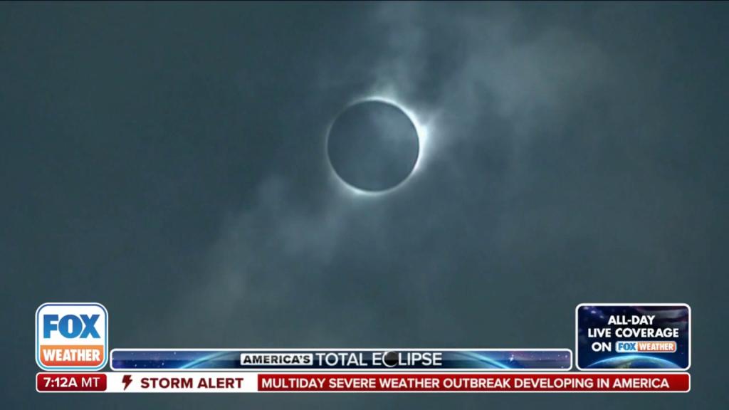
Cloudy skies may obstruct views of the upcoming solar eclipse on April 8 for parts of the US, particularly in the zone of totality stretching from Texas to Maine. Over 30 million Americans are expected to witness the event, with clear skies being crucial for optimal viewing. While early forecasts indicate potential cloud cover in inland areas like Ohio and Indiana, experts advise staying flexible and monitoring the weather closely. Protective eyewear is essential for safe viewing, even if the sun is obscured by clouds.
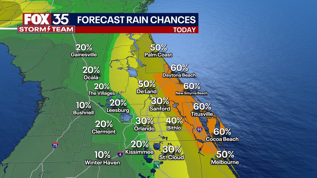
Central Florida can expect a cloudy, rainy, and breezy day with passing showers and gusty breezes. Rain chances will be highest along the coastal areas, with a flood watch in effect. Highs will be in the mid-upper 70s, with some areas reaching near 80 degrees. Beaches will experience high surf, coastal flooding, and a high rip current risk. Theme parks will have cloud cover and passing showers, making it a challenging day. A FOX 35 Weather Impact Day has been issued for Thursday as heavy rain moves across the region. The tropics are being monitored for a potential low pressure system, but there is currently no threat to Florida.
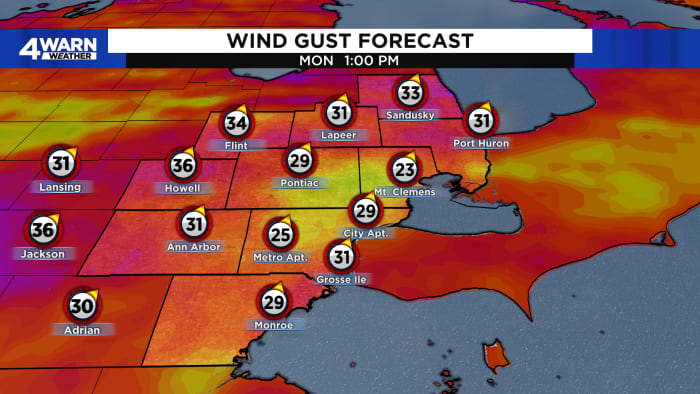
Rain showers and gusty winds are expected to move into Metro Detroit next week as a cold front approaches the region. On Monday, winds could gust as high as 30 to 35 mph, accompanied by rain showers. Temperatures will be in the lower 60s on Monday before cooling down to the middle 50s on Tuesday. Another round of rain is forecasted for Wednesday, with temperatures reaching around 50°F. The end of the week and the start of the weekend will bring mostly cloudy skies and colder temperatures in the upper 40s to mid 40s.
The weekend weather will be mostly cloudy due to a weather system in the Great Lakes region, with temperatures gradually warming up. Clocks should be turned back tonight, resulting in earlier sunsets. Dry conditions and areas experiencing drought will persist for the next few days, with rain expected at the end of next week.
The D.C.-area is expected to experience continued record warmth into the weekend, with temperatures potentially reaching the 80s. Cloud levels are uncertain, but tomorrow is expected to be the least cloudy day. There is a slight chance of showers on Sunday, but most outdoor plans should be unaffected. The weather may turn cooler and breezier on Monday, with increased shower chances. Tuesday could see persistent clouds and cooler temperatures in the upper 40s to mid-50s.
The D.C.-area forecast calls for mostly cloudy skies with a chance of showers throughout the day and into tonight. Temperatures will be warm, reaching the mid-70s to around 80 degrees. Rain amounts are expected to be light, making it suitable for outdoor activities. A cold front will move through tomorrow, bringing showers in the morning and clearing skies in the afternoon. Sunday will be cooler with high temperatures around 60 degrees and gusty winds. The following days will be partly sunny with temperatures in the 60s to near 70 degrees.
The D.C.-area can expect mostly cloudy skies and light shower chances for the next few days, with temperatures ranging from the mid-60s to near 70. The weather pattern is expected to continue through Thursday and Friday, with a slight improvement over the weekend as high pressure edges closer, potentially bringing more sunshine.
The remnant rains of Ophelia are decreasing in intensity and coverage, with cloudy skies and chances of showers and drizzle persisting until late afternoon Monday. High temperatures will be similar to today, with slightly less humidity and more breeziness. Rainfall accumulations in the region have been around 3 inches, helping to alleviate drought conditions.
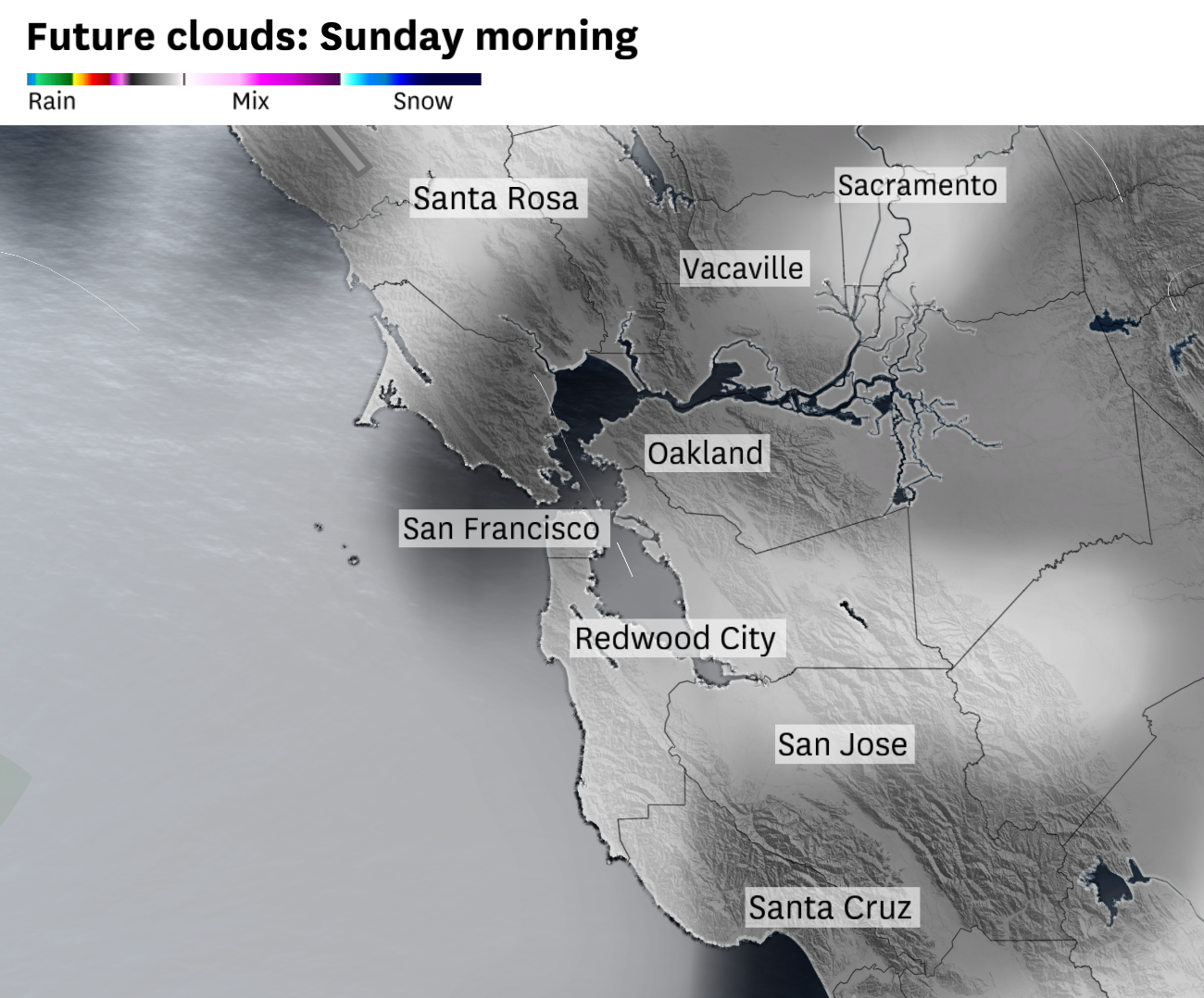
Overcast skies and chilly winds are expected for San Francisco's Pride Weekend, with areas of low pressure off the coast of California leading to clouds, fog, and mist across the city. Visitors are advised to bring a sweater or light jacket for Pride festivities, with temperatures in the upper 50s in the morning and mid to upper 60s in the afternoon. Gusts up to 20 mph are possible, and intermittent drizzle may occur between midnight and 6 a.m. on some days. The North Bay will experience a subtle warming trend, while the East Bay will have rounds of morning clouds and afternoon sun.
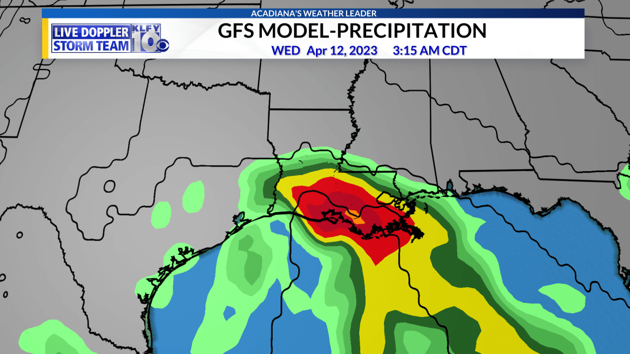
Mostly cloudy skies will continue today with high temperatures reaching low-mid 70s if there is sunshine, but struggling to reach 70 degrees if the low cloud deck persists. A cut-off low-pressure system will develop near the Louisiana coast on Tuesday, increasing storm chances across the area with an additional 1-3 inches of rainfall possible this upcoming week, especially along and south of I-10. The unsettled weather pattern is expected to continue into next weekend.
The D.C. area will experience warm weather with a risk of strong afternoon storms today, followed by cooler temperatures and cloudy skies on Friday and Saturday. Easter Sunday will bring back sunshine and slightly warmer temperatures, while Monday will be a perfect spring day with sunny skies and gentle breezes.