Tag

United States Geological Survey

All articles tagged with #united states geological survey

natural-disasters1 year ago

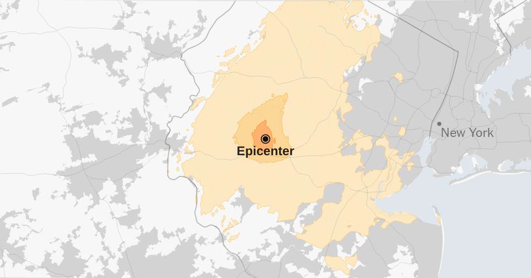
"Unprecedented East Coast Earthquake Shakes Millions from New York to Washington"

A 4.8-magnitude earthquake centered in Whitehouse Station, New Jersey, was felt by an estimated 42.8 million people across the US East Coast, making it the largest quake to hit the New York area in over a century. An aftershock was reported, and initial indications suggested a 4.0-magnitude quake southwest of Gladstone, New Jersey, according to the United States Geological Survey.

natural-disasters1 year ago

"4.8-Magnitude Earthquake Rattles East Coast from New Jersey Epicenter"

A 4.8-magnitude earthquake struck New Jersey, causing light shaking across the New York City metropolitan area and from Philadelphia to Boston. Seismologists are reviewing data and may revise the earthquake's reported magnitude, while aftershocks in the region are being monitored. This quake had the third-highest magnitude in the available data for the area, and aftershocks can occur days, weeks, or even years after the initial earthquake, potentially affecting already damaged locations.

natural-disasters1 year ago

"4.6-Magnitude Earthquake Shakes Southern California, Startles Residents and Pets"

A 4.6-magnitude earthquake centered near Malibu, California, rattled the Los Angeles area, with no major damage or injuries reported. The quake occurred at 1:47 p.m. local time and was followed by several smaller aftershocks, prompting a flurry of social media posts. While residents reported feeling the shake, no significant structural damage was reported, according to authorities.

natural-disasters1 year ago

"Oklahoma Takes Action After 5.1 Magnitude Earthquake"

A 5.1 magnitude earthquake struck near Oklahoma City, followed by smaller quakes, causing minimal damage and no reported injuries. The temblor, centered near Prague, was followed by at least eight smaller earthquakes, with the area having a history of seismic activity linked to wastewater injection from oil and gas extraction. Regulatory actions have been taken to limit injection wells, and the Oklahoma Corporation Commission has directed producers to close some wells and reduce volumes in others.

natural-disasters2 years ago

"Mapping the Risk: Predicting Damaging Earthquakes Across the US"

The United States Geological Survey has warned that nearly 75% of the U.S. could face potentially damaging earthquakes and intense ground shaking in the next 100 years, with new maps showing the areas most at risk. The model highlights seismic activity in California, Alaska, Hawaii, and the central and northeastern Atlantic Coastal corridor, including major cities like Washington, D.C., Philadelphia, New York, and Boston. The USGS hopes the model will enhance public safety and provide critical information for architects, engineers, and policymakers, with implications for earthquake retrofitting and construction practices.

health-and-environment2 years ago

Widespread Presence of PFAS "Forever Chemicals" in US Tap Water Revealed by Study

A new study by the United States Geological Survey (USGS) found that approximately 45% of tap water faucets across the United States contain one or more PFAS (per- and polyfluorinated alkyl substances), also known as "forever chemicals." The study tested tap water from 716 locations and discovered PFAS in both private wells and public supply sites. PFAS have been linked to various health issues, including certain types of cancer, and are known to persist in the environment for extended periods. The study also revealed that urban areas and regions near potential PFAS sources are more likely to have higher levels of contamination. The Environmental Protection Agency (EPA) has proposed a federal rule to require companies to report the presence of PFAS in their products.

science2 years ago

Unprecedented volcanic eruption causes intense lightning storm and surprises scientists.

A powerful volcanic eruption that occurred on January 15, 2022, has led to never-before-seen events, including lightning intensity and the formation of donut-shaped rings of lightning that surfed along the crests of circular ripples. The eruption was captured by NASA satellites, and a team of researchers led by the United States Geological Survey utilized advanced sensors to map the eruption. This type of volcanic event, known as a phreatoplinian, occurs only when magma erupts through the water.

natural-disaster2 years ago

4.4 Magnitude Earthquake Hits Northern California's Lake County.

A 4.4 magnitude earthquake hit the Bay Area on Tuesday evening, centered near the community of Cobb in Lake County. Tremors were felt in Oakland, Lakeport, Santa Rosa, and Cotati. The United States Geological Survey reported a 2.5 magnitude earthquake shortly afterward a couple of miles north of the first earthquake and in The Geysers, which is about a 10-mile drive south of Cobb. No damages have been reported yet.