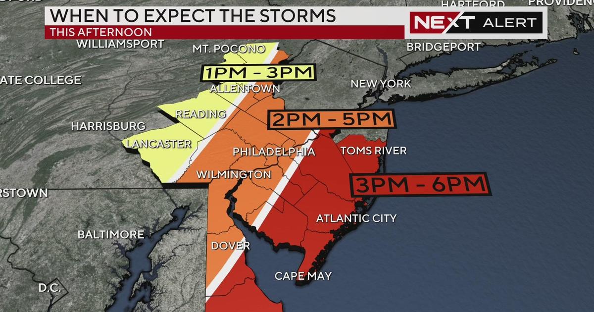
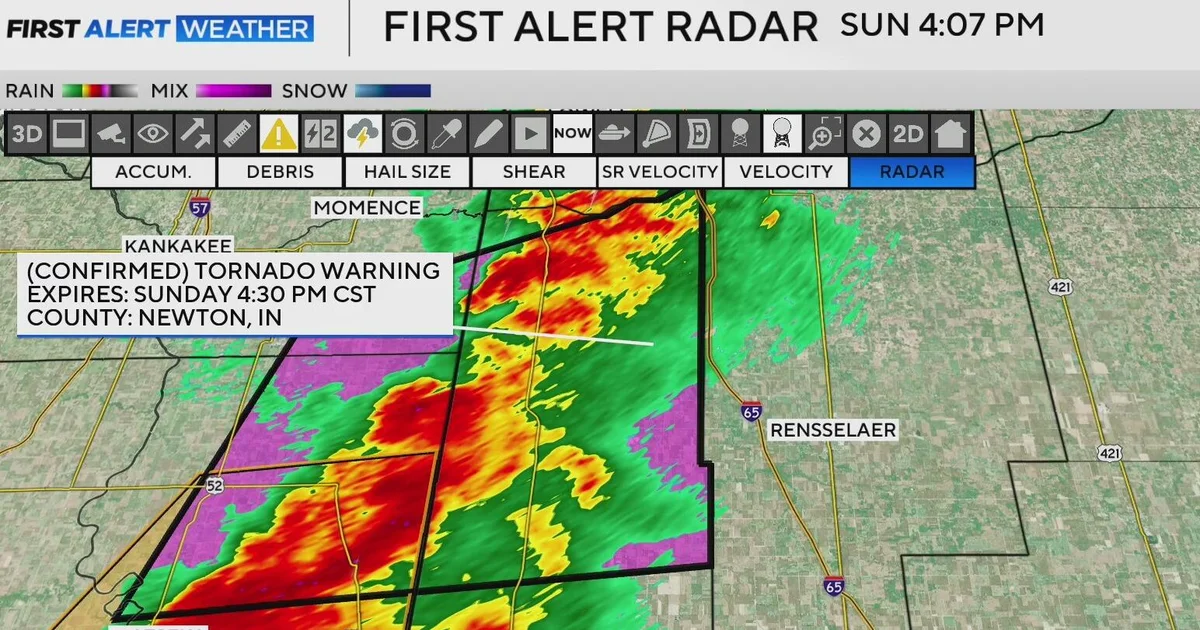
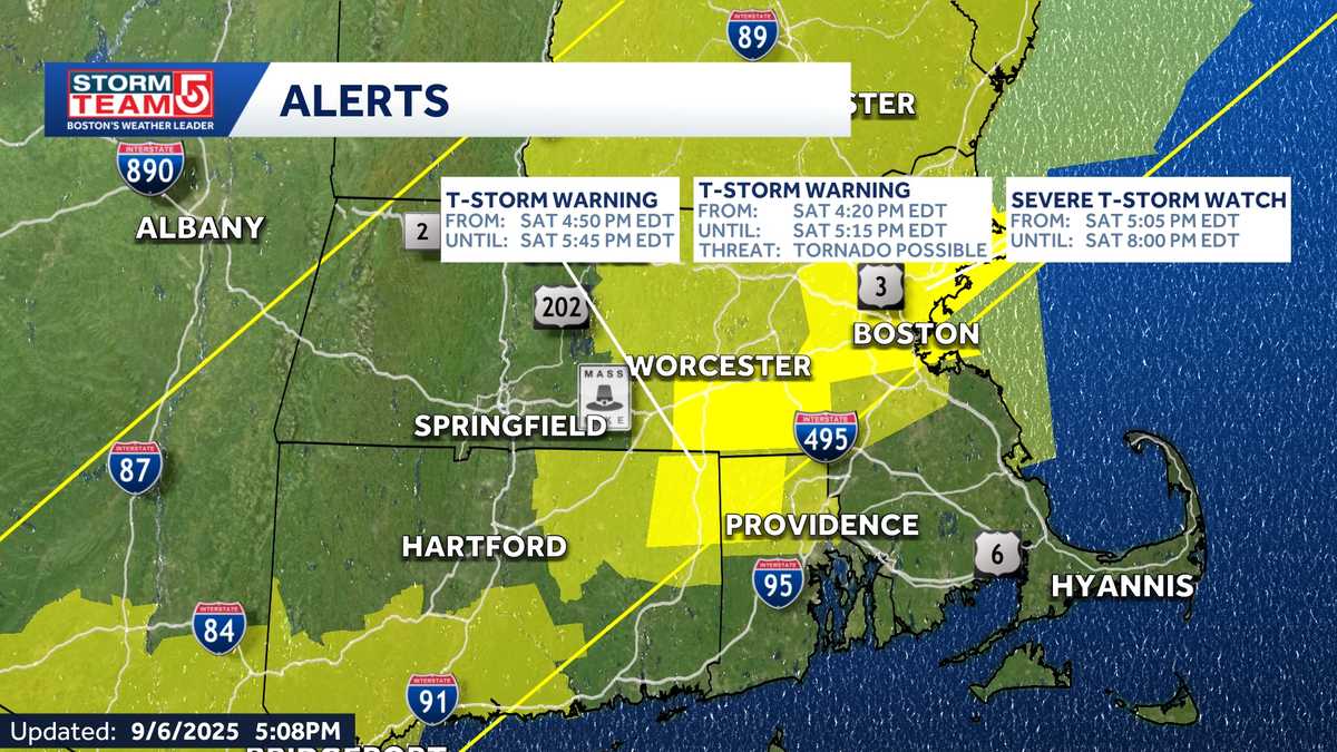
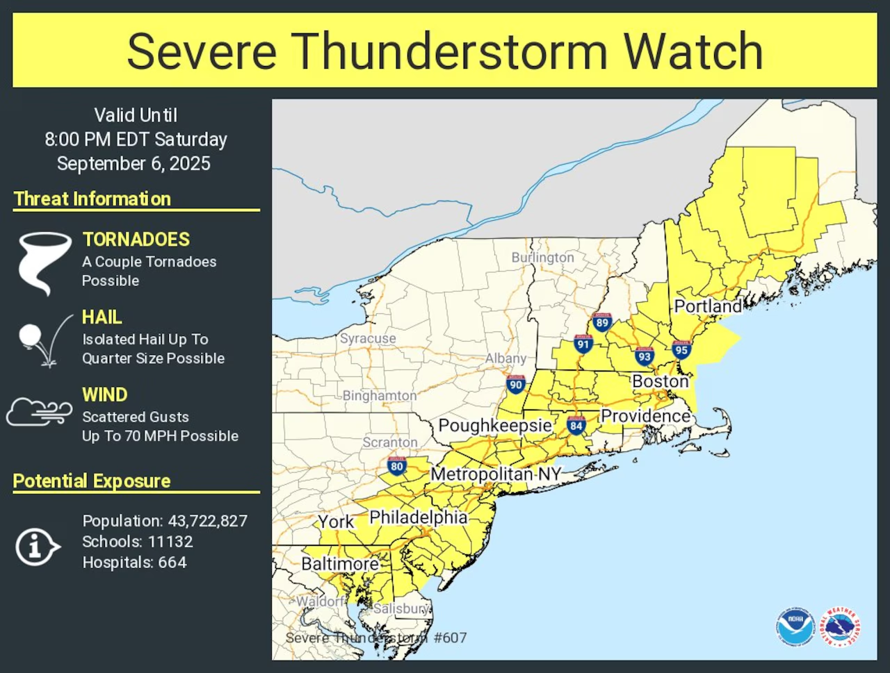
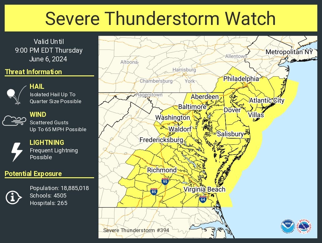
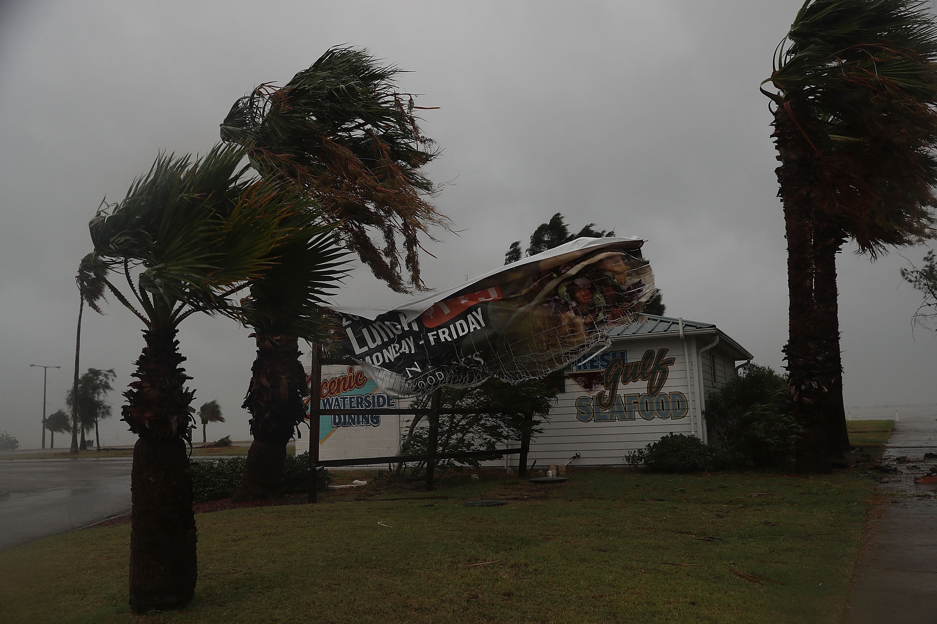
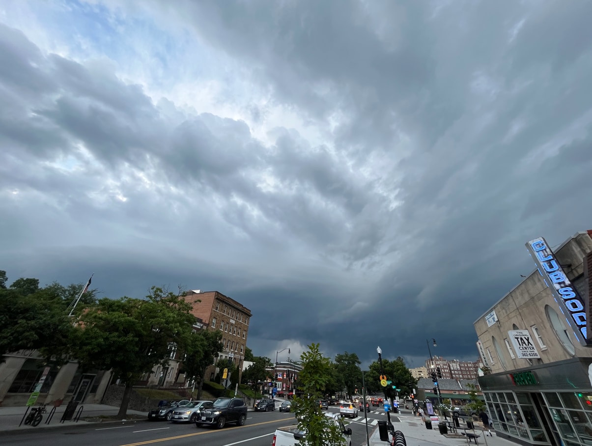
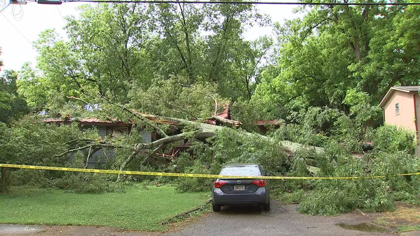
Severe weather affected Chicago and Northwest Indiana, including thunderstorms, strong winds, and a tornado warning that has since expired. The region experienced flight cancellations, wind advisories, and upcoming cold temperatures with snow and wind chills below zero, prompting the opening of a warming center in Aurora. Other parts of the Midwest faced heavier snow and blizzard conditions.
A series of severe thunderstorms with damaging winds, hail, and a low tornado risk are impacting central and western Massachusetts, prompting warnings and safety advisories. The storms are most intense northwest of Boston, with conditions expected to improve Sunday. Residents are advised to seek shelter and stay informed.
A severe thunderstorm watch is in effect for parts of Massachusetts and surrounding states until 8 p.m., with the potential for damaging winds, hail, and tornadoes, especially in inland areas like Central and Western Massachusetts. Residents are advised to stay weather aware as storms are expected to weaken after sunset, with some areas experiencing severe weather including tornado warnings and hail.
A tornado warning near Iowa Speedway led to the cancellation of IndyCar practice sessions scheduled for Friday, as severe weather including a tornado touched down close to the track, prompting safety measures and rescheduling of events for Saturday.
The National Weather Service has issued a tornado warning and flash flood alerts for Washington DC and surrounding areas due to severe thunderstorms expected to bring damaging winds, flooding, and the potential for tornadoes, urging residents to take immediate shelter and stay vigilant.
A teenager was struck by lightning in New York City as severe thunderstorms, including a large tornado warning, affected the Northeast, causing power outages and flight cancellations across the region.
San Francisco experienced its first-ever tornado warning as a severe storm hit the region, causing significant power outages and damage. The warning was issued for parts of the city and northern San Mateo County, with winds reaching up to 60 mph. Although the warning was lifted shortly after, authorities are assessing the damage to confirm if a tornado occurred. This event follows a recent tsunami warning in the area, highlighting a period of unusual weather activity.
Downtown San Francisco experienced its first-ever tornado warning as severe storms hit the city, following a recent tsunami warning. The tornado threat ended after the storm moved northeast, but high winds and a flood advisory were issued, with gusts reaching 83 mph. Over 10,000 residents lost power. California averages nine tornadoes annually, but none had been recorded in downtown San Francisco before. The recent tsunami warning was due to a 7.0-magnitude earthquake off the coast, highlighting the region's vulnerability to natural disasters.
A tornado warning was issued for San Francisco, prompting emergency alerts that urged residents to take cover immediately. This rare weather event in the region caused concern among locals, highlighting the importance of staying informed and prepared for unexpected weather conditions.
The National Weather Service has issued a severe thunderstorm watch for the D.C. area until 9 p.m. due to a cold front that could trigger intense storms with strong winds, heavy rain, lightning, and possibly hail. A tornado warning was briefly issued but later canceled. The most intense storms are expected east of Interstate 95, with the primary risks being damaging wind gusts and heavy downpours. The weather is expected to improve by the end of the workweek.
Texas residents in the Fort Worth area were urged to seek shelter as an "extremely dangerous" storm with winds up to 80 mph and large hail approached. The National Weather Service issued severe thunderstorm and tornado warnings for multiple counties, warning of potential serious injury and significant property damage. The storm follows a month of severe weather in Texas, including deadly tornadoes and flooding.
Severe storms that triggered multiple warnings, including a tornado warning, have moved out of the D.C. region and into the Chesapeake Bay area. The storms caused downed trees and wires, flash flooding, and road closures in some areas. All watches and warnings for the D.C. region have been lifted, and it remains unconfirmed if a tornado touched down. Residents are advised to stay alert for any further weather updates.
Severe thunderstorms and at least one tornado warning affected several metro Atlanta counties on Memorial Day, causing power outages, fallen trees, and property damage. Warnings were issued throughout the day for various counties, with the main threats being damaging winds, hail, and heavy rain. Despite tornado sirens and warnings, no confirmed tornado touchdowns were reported.
Severe weather is expected in the Philadelphia region on Memorial Day, with a NEXT Weather Alert issued for Monday. Scattered showers will occur in the morning, followed by a line of storms in the afternoon and early evening, bringing heavy rain, potential flash flooding, and gusty winds. The greatest impact in Philadelphia will be between 2-5 p.m., with the Jersey Shore and Delaware hardest hit from 3-6 p.m. The tornado threat is low but not zero. Conditions will clear up by late Monday night, leading to a sunny and seasonable Tuesday.
Severe thunderstorms with heavy rain, wind gusts up to 65 mph, and hail are expected to hit New Jersey on Memorial Day, potentially causing dangerous conditions and leading to the cancellation of several parades. The National Weather Service warns that a tornado cannot be ruled out, and residents should prepare for localized flash flooding and damaging winds.