Tag

Snowshowers

All articles tagged with #snowshowers

"Weekend Storms Give Way to Quieter, Drier Conditions with Soaking Rain on the Horizon"

Originally Published 2 years ago — by ABC27

Featured image for "Weekend Storms Give Way to Quieter, Drier Conditions with Soaking Rain on the Horizon"
Source: ABC27

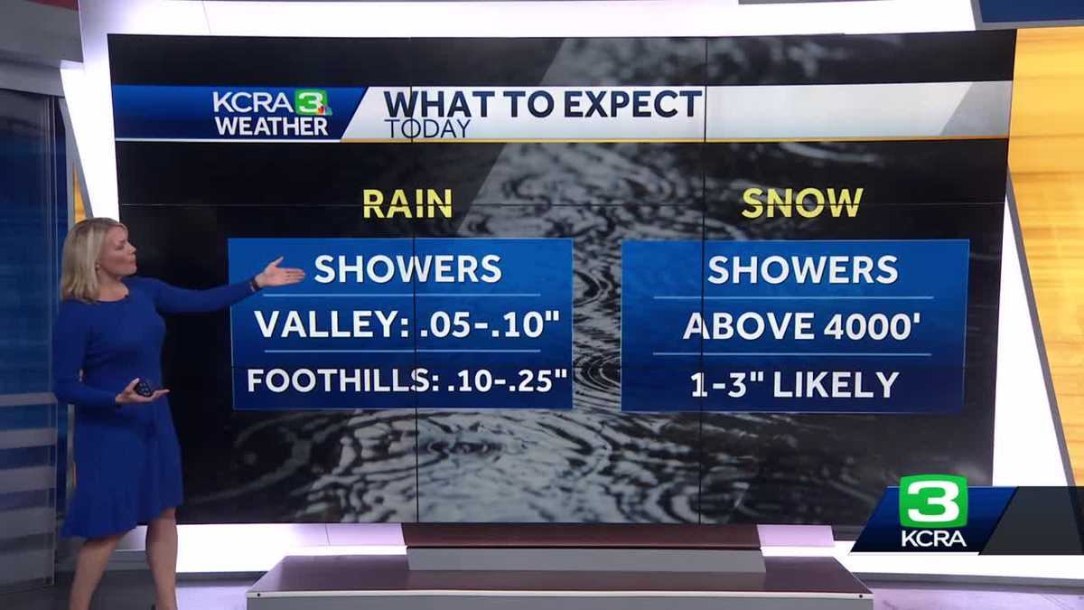
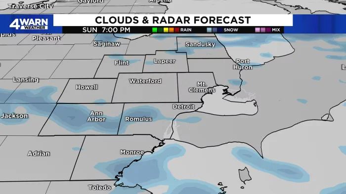
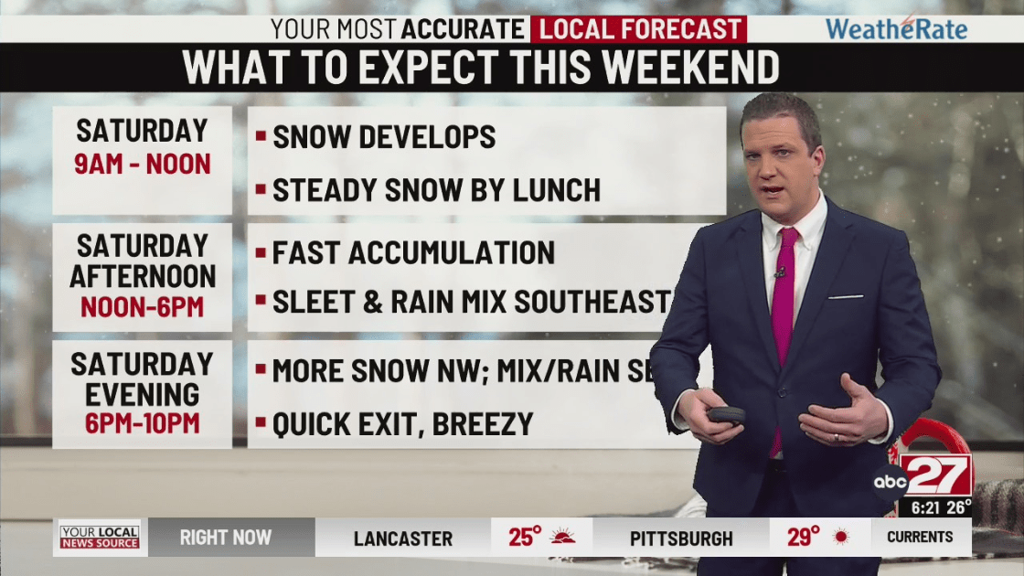
The current storm is concluding with sleet and rain this evening, leading to a drier night with temperatures around freezing. Sunday will see morning snow showers and breezy conditions with highs in the low 40s. Snow accumulation from this storm won't last as temperatures rise, and another system is expected to bring a mix of snow and sleet on Tuesday morning, turning to rain with highs near 50°. Up to 1 inch of rain is anticipated. Further updates on the upcoming weather changes will be provided throughout the weekend.

"Active Weather Weekend: Rain, Snow, and Wintry Mix Across Ohio"

Originally Published 2 years ago — by ABC6OnYourSide.com

Featured image for "Active Weather Weekend: Rain, Snow, and Wintry Mix Across Ohio"
Source: ABC6OnYourSide.com

Columbus, Ohio, is experiencing a wintry weekend with a Winter Weather Advisory in effect for several counties until Saturday afternoon, expecting up to 1 inch of snow and a glaze of ice. Slippery roads and slushy conditions are anticipated. Snow showers will continue into Saturday night, followed by a wintry mix on Sunday. A brief respite is expected on Monday, but another storm system will bring heavy rain and windy conditions on Tuesday. Snow emergencies have been declared in multiple counties.

"Snowfall Predictions Ramp Up for Metro Detroit with Multiple Winter Storms Ahead"

Originally Published 2 years ago — by WDIV ClickOnDetroit

Featured image for "Snowfall Predictions Ramp Up for Metro Detroit with Multiple Winter Storms Ahead"
Source: WDIV ClickOnDetroit

Metro Detroit is expected to experience light snow over the weekend with higher chances of snow showers on Sunday and potential light accumulation. A more significant weather system will bring mixed precipitation, including rain and snow, along with gusty winds next week, starting Tuesday. Travelers, including Michigan fans headed to Houston for the College Football Playoff National Championship, may face weather-related challenges. Weather forecasts will continue to evolve as the system approaches.

"Arctic Blast and Snowfall Predictions Sweep Across Midwest Cities"

Originally Published 2 years ago — by NBC Chicago

Featured image for "Arctic Blast and Snowfall Predictions Sweep Across Midwest Cities"
Source: NBC Chicago

Chicago is bracing for two waves of winter weather, with the first bringing snow showers over the weekend and the second, an "uncertain" system, potentially arriving early next week with varying predictions of snow and rain. The first wave is expected to result in 1-2 inches of snow, mainly affecting southern counties and parts of Northwest Indiana. The second system's impact remains unclear, with forecast models showing a wide range of possible outcomes, from significant snow accumulation to mostly rain. The National Weather Service emphasizes substantial uncertainties in the forecast, and temperatures are expected to drop into the 20s by the second weekend in January.

"Weekend Weather Watch: From Scattered Snow Showers to Persistent Cold and Potential Squalls"

Originally Published 2 years ago — by WMUR Manchester

Featured image for "Weekend Weather Watch: From Scattered Snow Showers to Persistent Cold and Potential Squalls"
Source: WMUR Manchester

The weather forecast indicates a mostly cloudy Thursday with a few scattered snow showers, particularly in northern areas and across the mountains, with gusty winds making temperatures feel cooler. Highs will reach the upper 30s before dropping in the evening. Friday will be sunny and brisk, leading to a quiet start to the weekend. However, a potential storm late Saturday night into Sunday could bring the first widespread snow of the season, with the storm's track determining the snowfall amount and impact. Weather updates will become more certain as the week progresses.

"California Braces for Wet Commute and Sierra Snow as Storms Sweep West Coast"

Originally Published 2 years ago — by KCRA Sacramento

Featured image for "California Braces for Wet Commute and Sierra Snow as Storms Sweep West Coast"
Source: KCRA Sacramento

Northern California is experiencing wet weather, with chain controls in effect for the Sierra region due to snowfall reaching elevations as low as 3,000 feet. Commuters in the Sacramento area can expect a soggy morning with intermittent showers, which are forecasted to ease by the afternoon. Sierra resorts have received significant snowfall, and additional accumulation is expected. Caltrans has closed several passes for the winter season. The rest of the week looks to have a mix of dry days and potential rain and snow on Saturday.

"January 2024: Snow's Return to Michigan Revives Weather and Tourism Outlook"

Originally Published 2 years ago — by MLive.com

Featured image for "January 2024: Snow's Return to Michigan Revives Weather and Tourism Outlook"
Source: MLive.com

Michigan is set to experience a return of snow showers on New Year's Eve after a mostly snowless December. Temperatures will be milder than average but cooler than recent days, with lows in the 30s across the Lower Peninsula and mid to upper 20s in the Upper Peninsula. Light snowfall is expected throughout the day, with less than an inch of accumulation in northern Lower Michigan. Evening celebrations are likely to be chilly with temperatures dropping after sunset, but the weather will remain relatively calm, allowing for outdoor New Year festivities.

"New Year's Eve Weather: From Sunshine to Snow Showers and Chilly Temps Across the Midwest"

Originally Published 2 years ago — by WDIV ClickOnDetroit

Featured image for "New Year's Eve Weather: From Sunshine to Snow Showers and Chilly Temps Across the Midwest"
Source: WDIV ClickOnDetroit

As New Year's Eve approaches, the weather forecast indicates a shift from rain to sunshine at the start of the weekend, followed by the return of snow showers by the end of the weekend. Temperatures are expected to drop to the lower 40s on Saturday and then to the upper 30s on Sunday, with little to no snow accumulation. The start of 2024 will see mostly cloudy skies with temperatures remaining in the upper 30s, and the weather pattern of clouds and occasional snow showers is expected to continue into the middle of next week.

"Alabama Braces for Mixed Precipitation with Snow Showers into the Weekend"

Originally Published 2 years ago — by AL.com

Featured image for "Alabama Braces for Mixed Precipitation with Snow Showers into the Weekend"
Source: AL.com

The National Weather Service forecasts possible snow showers in northern Alabama later today, with the best chance for snowfall occurring this evening into the overnight hours. Accumulation is expected to be less than a quarter inch and limited to elevated and grassy surfaces due to relatively warm ground temperatures. Rain showers are also expected today with temperatures in the 40s and 50s, potentially mixing with or turning to snow from 6 p.m. until midnight. Further snow chances are being monitored for next Tuesday.

"Wintry Mix and Snow Showers Set to Disrupt Travel in East Tennessee and Midstate Areas"

Originally Published 2 years ago — by 13WHAM-TV

Featured image for "Wintry Mix and Snow Showers Set to Disrupt Travel in East Tennessee and Midstate Areas"
Source: 13WHAM-TV

Rochester, NY, is set to experience a mix of rain and snow showers with temperatures holding in the 40s during the day and dropping to the mid-30s at night. Snow accumulation is expected to be minimal, with less than an inch even on hilltops. The weather pattern includes a front moving south across the area, bringing a focus for precipitation and a possibility of scattered rain or snow showers into the next day.