Tag

Pacific Ring Of Fire

All articles tagged with #pacific ring of fire

natural-disasters1 year ago

"Taiwan Earthquake: Impact and Aftermath"

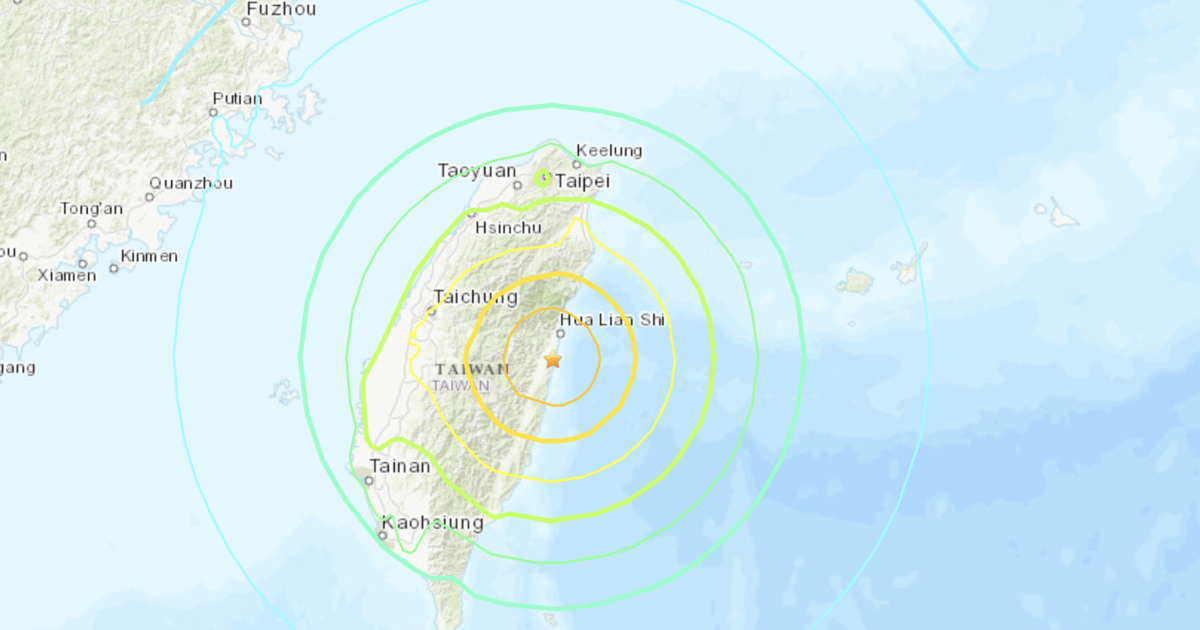
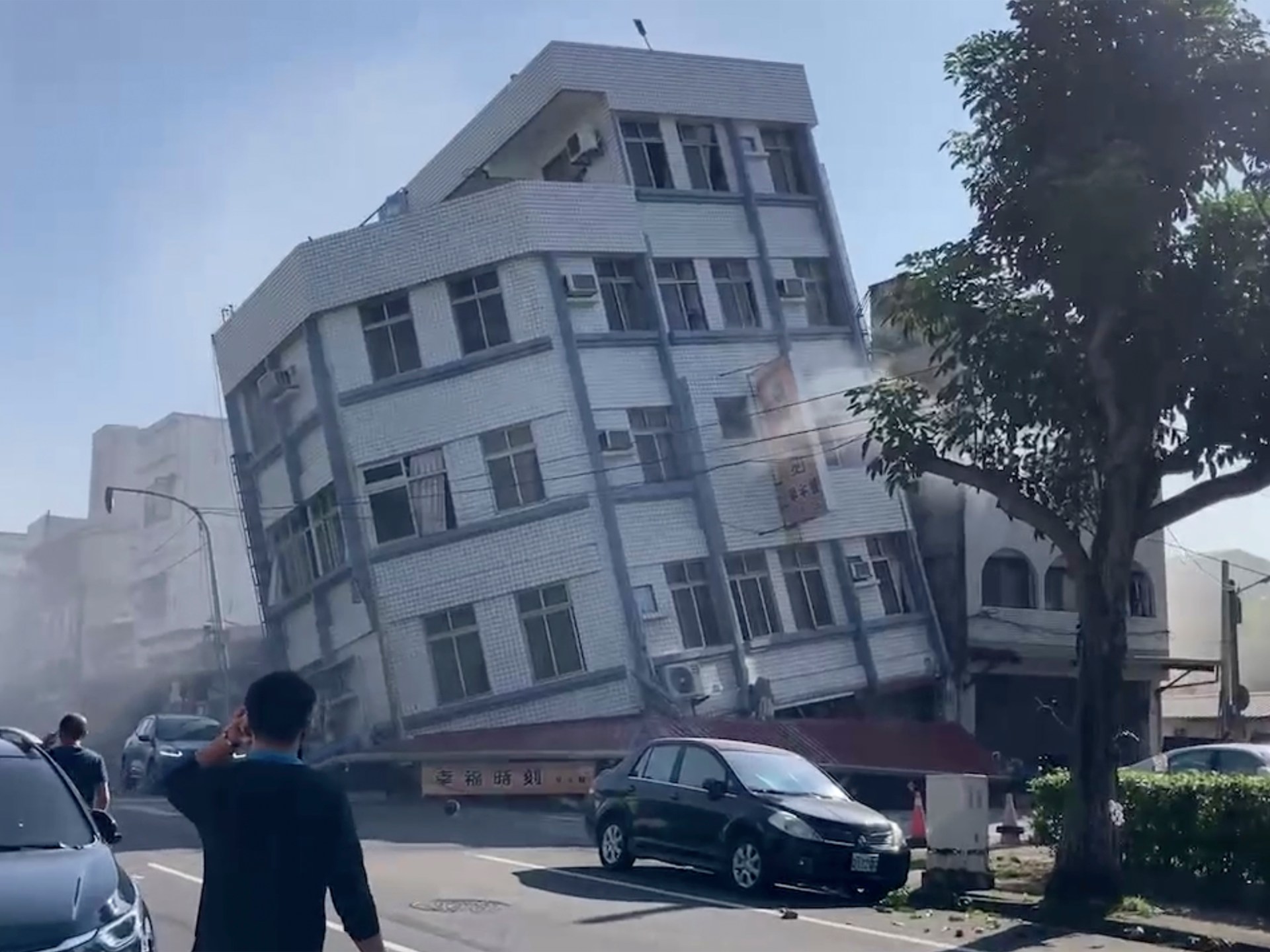
Taiwan was hit by its strongest earthquake in 25 years, resulting in at least four deaths, hundreds of injuries, and collapsed buildings in Hualien County. The earthquake triggered tsunami warnings, but the threat has since passed in Japan, the Philippines, and Taiwan. The earthquake, estimated between 7.2 and 7.7 magnitude, caused panic in Taipei and brought back memories of the devastating 1999 quake. Despite the strict building regulations and disaster awareness programs in Taiwan, the earthquake's intensity led to significant damage and casualties.

natural-disasters1 year ago

"7.4-Magnitude Earthquake Strikes Taiwan, Triggering Tsunami Warnings and Causing Devastation"

A 7.4-magnitude earthquake struck near Taiwan, triggering tsunami warnings for coasts within 300 km of the epicenter, affecting China, Taiwan, and Japan. The quake collapsed buildings, including a five-story structure in Hualien, and disrupted transportation services across the island. Japan also issued a tsunami alert for the southern Japanese island group of Okinawa, with the first wave believed to have arrived on the coasts of Miyako and Yaeyama islands. Multiple aftershocks were felt, and the earthquake is considered the biggest in Taiwan since 1999.

natural-disasters1 year ago

"7.5-Magnitude Earthquake Sparks Tsunami Warnings in Taiwan and Japan"

A 7.4-magnitude earthquake struck off Taiwan's eastern coast, prompting tsunami warnings for Taiwan and southern Japan. The quake's epicenter was near Hualien, and aftershocks, including a 6.5-magnitude one, were felt. Both Taiwan's Central Weather Administration and the Japan Meteorological Agency issued tsunami warnings. Taiwan, located on the Pacific Ring of Fire, experiences frequent seismic activity, and Hualien County, where the quake hit, is a popular tourist destination.

natural-disasters2 years ago

"Mount Marapi Erupts Twice in Weeks, Prompting Evacuations in Indonesia"

Indonesia's Marapi volcano erupted for the second time in just over a month, spewing volcanic ash and prompting warnings for residents and visitors to stay away from the area. The 2,891-meter-high volcano in West Sumatra province has been active for decades and is among the most active in Indonesia, which lies on the Pacific Ring of Fire. The recent eruption follows a previous one on December 3 that resulted in the deaths of 23 hikers.

natural-disasters2 years ago

Powerful Earthquake Triggers Tsunami Warning in Southern Philippines

A powerful 7.6 magnitude earthquake struck off the coast of Mindanao in the southern Philippines, prompting a tsunami warning. The Pacific Tsunami Warning Center predicted that tsunami waves could hit parts of the Philippines, Indonesia, Palau, and Malaysia. Residents along the coast were advised to evacuate to higher ground, while boat owners were instructed to secure their vessels and move away from the waterfront. The Philippines, located on the Pacific Ring of Fire, frequently experiences earthquakes, volcanic eruptions, and typhoons.

natural-disasters2 years ago

Powerful Earthquake Triggers Tsunami Alert in Southern Philippines

A 7.6-magnitude earthquake struck off the coast of Mindanao in the Philippines, prompting a tsunami warning. The quake, which occurred at a depth of 32 kilometers, has not yet resulted in any reported damage or casualties. The Pacific Tsunami Warning Center expects tsunami waves to hit parts of the southern Philippines, Indonesia, Palau, and Malaysia. Residents along the coast of southern Surigao del Sur and Davao Oriental provinces have been advised to evacuate to higher ground, while boat owners in affected areas have been instructed to secure their boats and move away from the waterfront. The Philippines, located on the Pacific Ring of Fire, frequently experiences earthquakes, volcanic eruptions, and typhoons.

natural-disasters2 years ago

"Undersea Volcanic Eruption Forms Temporary New Island off Japan's Coast"

An undersea volcano off the coast of Iwo Jima, Japan, erupted three weeks ago, resulting in the formation of a new island. The island, about 100 meters in diameter and 20 meters high, was created by volcanic ash and rocks piling up on the seabed. However, experts believe the island may not last long due to its crumbly formation, which is easily eroded by waves. Japan, located in the Pacific Ring of Fire, has 111 active volcanoes.

natural-disasters2 years ago

Undersea Volcano Creates Ephemeral New Island near Japan

An undersea volcano off the coast of Japan has erupted, resulting in the formation of a new island. The island, located near Iwo Jima, emerged within 10 days and reached a diameter of 100 meters and a height of 20 meters. However, experts believe that the island may not last long due to its crumbly formation, which is easily eroded by waves. The volcanic activity has subsided, and further analysis is being conducted to determine the island's composition. Japan, situated on the Pacific "ring of fire," has 111 active volcanoes.

disaster2 years ago

Massive Rescue Operation as Philippine Ferry Catches Fire at Sea.

The Philippine coast guard rescued all 120 passengers and crew from a ferry that caught fire while traveling between two islands. The cause of the fire is unknown, and officials have not yet specified where the rescued people were taken. The Philippines experiences regular earthquakes and volcanic eruptions due to its location on the Pacific "Ring of Fire."

natural-disasters2 years ago

Mayon volcano alert level raised in Philippines.

The alert level for the Mayon volcano in the Philippines has been raised to level three out of five due to the risk of a hazardous eruption within days. Villagers living within a 6km radius of the volcano's crater have been told to evacuate to safer ground. The Philippines lies along the Pacific Ring of Fire, a region prone to earthquakes and volcanic eruptions.

natural-disasters2 years ago

Philippines on high alert as volcano threatens nearby villages.

The alert level for Mayon volcano in the Philippines has been raised after superheated streams of gas, debris, and rocks cascaded down its upper slope. Villagers living within a 6-kilometer radius of the crater have been told to evacuate to safer grounds due to the danger of volcanic emissions, lava flows, rockfalls, and other hazards. Mayon is one of the most active volcanoes in the Philippines and last erupted violently in 2018, displacing tens of thousands of villagers. The Philippines lies along the Pacific Ring of Fire, a region prone to earthquakes and volcanic eruptions.

science-and-technology2 years ago

New satellite and GPS technology boost tsunami detection along the Pacific Ring of Fire.

Scientists at NASA's Jet Propulsion Laboratory are testing a new experimental monitoring system called GUARDIAN, which uses data from clusters of GPS and other satellites to detect potentially deadly tsunamis triggered by earthquakes, volcanoes, or other events. The system can search for clues by examining radio signals from global navigational satellite systems, which are reviewed by the JPL's Global Differential GPS network. The technology can produce details about a potential tsunami in about 10 minutes, providing up to an hour of advanced warning for people in danger depending on the tsunami's location from shore. The GUARDIAN team is currently focusing on the Pacific Ocean's Ring of Fire, where 78% of the more than 750 confirmed tsunamis between 1900 and 2015 occurred.

earth-observation2 years ago

Nishinoshima Island, Japan: A Stunning View from Space.

The Copernicus Sentinel-2 satellite captured an image of Nishinoshima Island, an uninhabited volcanic island in the northwest Pacific Ocean. The island has grown in size due to alternating periods of explosive activity and calm, with lava from various eruptions contributing to its growth. The yellowish discolouration of the water around the island is due to volcanic minerals, gas and seafloor sediment being stirred up by the volcanic activity. A plume of gas and steam can be seen rising from the volcano and drifting northeast over the Pacific Ocean. Satellite data can be used to better understand volcanic activity and provide early warnings to the aviation industry.

natural-disaster2 years ago

Indonesia shaken by 7.3 magnitude earthquake, brief tsunami warning issued.

A magnitude 7.3 earthquake hit west of Indonesia's Sumatra Island, triggering a tsunami warning for around two hours, which has since been lifted. The quake, at a depth of 84 kilometres, hit at about 3 a.m. local time. Indonesia suffers frequent earthquakes because it straddles the so-called Pacific Ring of Fire, a seismically active zone where different plates of the earth's crust meet.